
Three Forks, Montana
Three Forks | ||
|---|---|---|
City | ||
FIPS code 30-73975 | | |
| GNIS feature ID | 2412067[2] | |
| Website | http://www.threeforksmontana.us | |
Three Forks is a city in
History

The three rivers, west to east, were named by
The Lewis and Clark expedition visited the site on July 28, 1805. Meriwether Lewis in his journal entry wrote:
- "Both Capt. C. and myself corrisponded in opinion with rispect to the impropriety of calling either of these [three] streams the Missouri and accordingly agreed to name them after the President of the United States and the Secretaries of the Treasury and state..."[4]
One consequence of their decision to designate, map and name the Jefferson—the largest— as a separate tributary river, is that today the Mississippi River can arguably be called longer than the Missouri River because extensive re-channelization of the streambed for hydroelectric power projects has shortened the river while the Mississippi Delta has grown, lengthening the rival river.
Honored in Three Forks, the Indian woman Sacagawea is best known as the interpreter and guide for the Lewis and Clark Expedition. In 1800, she was captured by the Mennetaree tribe near the present site of Three Forks. She later returned to this area with Lewis and Clark and the Corps of Discovery. A statue of Sacagawea now sits in a park off Main Street.
The present-day city of Three Forks was founded September 17, 1908 by
The Milwaukee Land Co., platted the town and held a lot sale that day. Some buildings were moved to the present city from "Old Town Three Forks", a mile to the northeast. The city became a division point on the Milwaukee Road's Rocky Mountain Division and was an important hub for the railroad during the existence of the Milwaukee in Montana (1908-1980).Two banks for the town were chartered in 1909 and 1910; John Q. Adams financed construction of the latter one, the Three Valleys State Bank, whose building survives, is listed on the National Register of Historic Places, and serves as a local history museum. The town's early growth prospects foundered from the effects of economic depression, crop failures, and an earthquake that hit the town on June 27, 1925, damaging all of its brick buildings.[9] The town's population never reached the 10,000 level that some once hoped for, and dropped to about 1,000. Some prosperity returned during and after World War II, and population has grown modestly since.[9]
Geography
According to the United States Census Bureau, the city has a total area of 1.50 square miles (3.88 km2), of which 1.44 square miles (3.73 km2) is land and 0.06 square miles (0.16 km2) is water.[10]
Climate

Photo Gallery
-
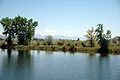
 The Bridger Mountains from Three Forks
 -
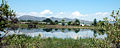
 The Bridger Mountains from Three Forks
 -
 The Bridger Mountains from Three Forks
 -
 Three Forks


Demographics
| Census | Pop. | Note | %± |
|---|---|---|---|
| 1910 | 674 | — | |
| 1920 | 1,071 | 58.9% | |
| 1930 | 884 | −17.5% | |
| 1940 | 876 | −0.9% | |
| 1950 | 1,114 | 27.2% | |
| 1960 | 1,161 | 4.2% | |
| 1970 | 1,188 | 2.3% | |
| 1980 | 1,247 | 5.0% | |
| 1990 | 1,203 | −3.5% | |
| 2000 | 1,728 | 43.6% | |
| 2010 | 1,869 | 8.2% | |
| 2020 | 1,989 | 6.4% | |
| U.S. Decennial Census[11][3] | |||
2010 census
As of the
There were 785 households, of which 31.1% had children under the age of 18 living with them, 51.2% were married couples living together, 9.0% had a female householder with no husband present, 6.5% had a male householder with no wife present, and 33.2% were non-families. 28.4% of all households were made up of individuals, and 11.3% had someone living alone who was 65 years of age or older. The average household size was 2.37 and the average family size was 2.90.
The median age in the city was 40.8 years. 24.8% of residents were under the age of 18; 6.4% were between the ages of 18 and 24; 24.5% were from 25 to 44; 28.4% were from 45 to 64; and 15.8% were 65 years of age or older. The gender makeup of the city was 49.9% male and 50.1% female.
2000 census
As of the census
There were 686 households, out of which 35.4% had children under the age of 18 living with them, 59.3% were married couples living together, 5.8% had a female householder with no husband present, and 31.5% were non-families. 26.7% of all households were made up of individuals, and 12.1% had someone living alone who was 65 years of age or older. The average household size was 2.51 and the average family size was 3.08.
In the city, the population was spread out, with 28.4% under the age of 18, 6.0% from 18 to 24, 28.9% from 25 to 44, 21.8% from 45 to 64, and 15.0% who were 65 years of age or older. The median age was 38 years. For every 100 females there were 102.8 males. For every 100 females age 18 and over, there were 102.6 males.
The median income for a household in the city was $34,212, and the median income for a family was $39,938. Males had a median income of $30,086 versus $19,196 for females. The
Government
The City of Three Forks is a Mayor–council government form of government in which the City Council is chaired by an elected Mayor. These two entities form the legislative and executive branches of the government. There are six elected City Council members.[14]
Infrastructure
Three Forks Airport is a public use airport located 1 mile southeast of town.
A large beaver dam measuring 2,139 feet (650 m) long, 14 feet (4.3 m) high and 23 feet (7.0 m) thick at the base is located within the Three Forks area, which was the longest known beaver dam until 2007.[15]
Education
The municipality is in the Three Forks Elementary School District and the Three Forks High School District.[16] The Three Forks elementary and high school districts are both a part of Three Forks Public Schools.[17]
Three Forks Schools educates students from kindergarten through 12th grade.[18] Three Forks High School's team name is the Wolves.[19]
The Three Forks Community Library is a public library.[20]
Media
The Three Forks Voice is a weekly newspaper serving the area.[21]
References
- ^ "ArcGIS REST Services Directory". United States Census Bureau. Retrieved September 5, 2022.
- ^ a b U.S. Geological Survey Geographic Names Information System: Three Forks, Montana
- ^ a b "U.S. Census website". United States Census Bureau. Retrieved November 2, 2021.
- ^ Journals of the Lewis & Clark Expedition 28 July 1805. Retrieved 7 January 2020.
- ^ https://www.headwatersheritagemuseum.org/three-forks
- ^ https://www.hmdb.org/m.asp?m=192664
- ^ Three Forks Area Historical Society (pdf)
- ^ "Three Forks". Montana Place Names Companion. Montana Historical Society. Retrieved April 9, 2021.
- ^ a b Marcia Fairhurst; Kate Hampton (January 2005). "National Register of Historic Places Inventory/Nomination: Three Valleys State Bank / American National Bank; First Security Bank; Headwaters Historical Society; Headwaters Heritage Museum". National Park Service. Retrieved September 1, 2019. With accompanying five photos from 2004
- ^ "US Gazetteer files 2010". United States Census Bureau. Archived from the original on July 2, 2012. Retrieved December 18, 2012.
- ^ "Census of Population and Housing". Census.gov. Retrieved June 4, 2015.
- ^ "U.S. Census website". United States Census Bureau. Retrieved December 18, 2012.
- ^ "U.S. Census website". United States Census Bureau. Retrieved January 31, 2008.
- ^ "Three Forks City Government". City of Three Forks. Retrieved January 19, 2011.
- ^ "The Longest Beaver Dam in the World". EcoInformatics International. Retrieved March 16, 2025.
- U.S. Census Bureau. p. 1 (PDF p. 2/3). Retrieved October 4, 2024. - Text list
- ^ "Directory of Montana Schools". Montana Office of Public Instruction. March 13, 2024. p. 109/317. Retrieved March 13, 2024.
- ^ "Three Forks Schools". Three Forks Schools. Retrieved April 13, 2021.
- ^ "Member Schools". Montana High School Association. Retrieved April 19, 2021.
- ^ "Three Forks Community Library". Three Forks Community Library. Retrieved April 13, 2021.
- ^ "Home page". Three Forks Voice. Retrieved January 3, 2024.
External links
- City website
- Chamber of Commerce website
- Three Forks High School
- Three Forks Herald - local newspaper
- Gallatin County Emergency Management
Municipalities and communities of Gallatin County, Montana, United States | ||
|---|---|---|
| Cities |  | |
| Towns | ||
| CDPs | ||
| Other communities | ||
| Footnotes | ‡This populated place also has portions in an adjacent county or counties | |
| ||