
Three Sisters (Elk Valley)
| Three Sisters | |
|---|---|
.jpg) | |
| Highest point | |
| Elevation | 2,788 m (9,147 ft) |
| Prominence | 506 m (1,660 ft) |
| Coordinates | 49°34′36″N 115°06′08″W / 49.576633°N 115.102172°W |
| Geography | |
| Location | British Columbia, Canada |
| District | Kootenay Land District |
| Topo map | NTS 82G11 Fernie |
The Three Sisters is a
same name, located further north outside Canmore
.
The summit on the middle sister is the highest point in the Fernie area, at 2,788 m (9,147 ft). The Three Sisters is a popular subject for photographers.
Local legend states this peak came about because a young Indian chief could not choose between three girls for a wife, so he was turned into Mount Proctor. The maidens were so distraught, they prayed to be turned into mountains as well, and became the Three Sisters.
-
 Heiko's Trail, Water Gate, Three Sisters hike
 -
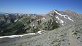 Heiko's Trail, Three Sisters hike
 -
 Heiko's Trail, Bisaro cave, Three Sisters hike
 -
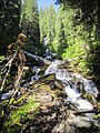 Heiko's Trail, Waterfall along the way, Three Sisters hike


See also
References
Wikimedia Commons has media related to Three Sisters, Elk Valley.