
Thurstaston Common
Notification 1954 / 1983 | | |
| Natural England website | ||
Thurstaston Common is an area of almost 250 acres (100 ha) of parklands, wood and heath between
Royden Country Park
is nearby and offers additional facilities.
The Common is a Site of Special Scientific Interest (SSSI)[1][2] and a local nature reserve.[3][4][5] From the top of the 298 ft (91 m) Thurstaston Hill there are views of the Dee Estuary (itself an SSSI) and across to the Clwydian Hills of North Wales. The area is popular with walkers and families.
SSSI
The common is underlain by
linnet.[1]
"Thor's Stone"
.jpg)
Thurstaston Hill is the location of Thor's Stone, a large
periglacial weathering of the sandstone, which was later exploited by quarrymen in the 18th and 19th centuries.[7]
Gallery
-
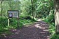 The path from School Lane
 -
 Pathway on Thurstaston Hill
 -
 Looking towards Arrowe Park and Liverpool
 -
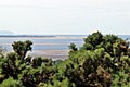 The view to Point of Ayr
.jpg)
.jpg)
.jpg)
.jpg)
References
- ^ a b "Thurstaston Common citation" (PDF). Sites of Special Scientific Interest. Natural England. Retrieved 26 July 2013.
- ^ "Map of Thurstaston Common". Sites of Special Scientific Interest. Natural England. Retrieved 26 July 2013.
- ^ "Thurstaston Common". Local Nature Reserves. Natural England. Retrieved 26 July 2013.
- ^ "Map of Thurstaston Common". Local Nature Reserves. Natural England. Retrieved 26 July 2013.
- ^ "Thurstaston Common Nature Reserve". Wirral Council. Retrieved 28 January 2011.
- ^ Journal of the British Archaeological Association, 1888
- ISBN 978-1-86077-512-3
It was a Viking place of sacrifice
External links
Wikimedia Commons has media related to Thurstaston Common.