
Tobar
Tobar | |
|---|---|
UTC+2 (CEST) | |
| Postal code | 09133 |
| Website | http://www.tobar.es/ |
Tobar (originally Tovar) is a
province of Burgos, Spain, within the Castile and León region. It is 35 km northwest of Burgos
.
General details
Tobar is located in a valley, surrounded of small hills, the Hormazuela river crosses the village from north to south.
The economy is based on agricultural farmers, mainly cultivating cereals, wheat and barley. The soil has much lime, but is fertile, providing good harvests most years.
Tobar has a continental climate, very cold in winter and very hot in summer. The minimum temperature in winter can descend to -10 °C; in summer the temperature can rise to 35 or 40 °C, but summer evenings are cool, even falling to 10 °C.
Gallery
-
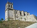 Saint Mary church
 -
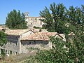
 View
View -
 View
View -
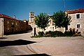 Main square


References
- ^ Municipal Register of Spain 2018. National Statistics Institute.
External links
42°28′59″N 3°55′59″W / 42.483°N 3.933°W
This article about a location in the province of Burgos, Spain is a stub. You can help Wikipedia by expanding it. |