
Tristan Island

Tristan Island or the Île Tristan is located at the mouth of the Pouldavid Estuary off the French port of
Now uninhabited, the island has become part of the national Parc naturel marin d'Iroise (Marine Park) established in 2007. It is accessible to tourists at low tide during spring tides most of the year, for a couple of hours at a time. A schedule is displayed on the mainland just across from the island, or can be obtained from the tourist office. At low tide, the island is connected to the mainland on the Douarnenez (or Eastern) side of the estuary.
History
Tristan bears traces of civilization dating back to the
One of the most colourful figures associated with Tristan was Guy Éder de la Fontenelle, a rebel-bandit who took possession of the island in 1595. He stationed his garrison of some 700 soldiers there, and proceeded to plunder most of the surrounding towns and villages.
After the island was acquired by Gustave le Guillou de Penanros in 1854, in the southern part of the island, La Planiche built a sardine press. Le Guillou de Penanros developed the harbour and the sardine processing plant on the island, the first of its kind. The sardine industry developed as Douarnenez' principal economic activity in the late 19th and early 20th centuries. In 1911, the island was purchased by Jean Richepin, an author and playwright. He built the rotunda and the Chapelle des Aviateurs commemorating the first transatlantic flight from Europe to the United States by
In 1995, the island was bought by Conservatoire du Littoral. It has carried out restoration work on the buildings and maintained the paths and gardens. The island is now maintained as part of the national Parc naturel marin d'Iroise (Marine Park) established in 2007.
Landscape
The small island has rocky coasts and sea cliffs. From its years of habitation, an orchard, and a tropical garden were cultivated and are still maintained. Several footpaths reveal views of the bay, as well as Tréboul and Port Rhu on the mainland. At the northern end of the island, a lighthouse and the ruins of an old fort can be seen.
Fauna and flora
Rabbits and lizards abound on the island, as do a wide variety of seabirds, especially
Offices for the Marine Park
The recently renovated canning factory is now used as offices for staff working for the national
Gallery
-
 The Aviators' Chapel
 -
 Former canning factory
 -
 The north coast
 -
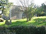 The fort


External links
- Conservatoire du littoral, Bretagne, Ile Tristan
- Le phare de l'île Tristan, Bretagne.com
- Description of Ile Tristan from the official Douarnenez website
- Tristan Island from Google Maps
Footnotes
- ^ Bulletin de la Société Archéologique du Finistère, 1905 (in French)
- ^ Etymologie et Histoire de Douarnenez from infoBRETAGNE.com. (in French) Retrieved 22 October 2007.
- ^ Parc marin d'Iroise, Feuille de route au Conquet from Kavadenn.com, 7 October 2007