
User:Heathmoor/Torà II
| This is not a Wikipedia article: It is an individual user's work-in-progress page, and may be incomplete and/or unreliable. For guidance on developing this draft, see Wikipedia:So you made a userspace draft. Find sources: Google (books · news · scholar · free images · WP refs) · FENS · JSTOR · TWL |
{Redirect|Torà| other similar terms without accent |Tora}}
Torà | |
|---|---|
Town | |
UTC+2 (CEST) | |
| Postal code | 25750 |
| Area code | 34 (Spain) + 973 (Lleida) |
Torà (Catalan pronunciation:
The municipality stretches along la Vall (valley) de la Riera (creek or brook) de Llanera (the Valley of Llanera's Creek) up to the confluence with the Llobregós River. Its orography is rather uneven with the lowest point at 430m and peaks rising up to 850m above sea level. The North sector features el Tossal (a kind of hill) de l'Aguda (L'Aguda's Hill), el Tossal de Sant Donat (Snat Donat's Hill), and the creek named la Riera de Llanera flowing across. On the other hand, the South sector features the hills el Tossal de Sant Pere and el Tossal de la Pineda, crossed by la Riera de Cellers, one of the Riera de Llanera's tributary brooks merging on its left. The town is settled by the left bank of the creek la Riera de Llanera, near the confluence with the Llobregós River, at the bottom of the mountain range la Serra de l'Aguda[1].
In 1968, the former municipality of Llanera was integrated to Torà.
Districts and neighbourhoods
These are the
- Cellers (South East)
- Claret (South East)
- Fontanet (Center)
- Llanera (North East)
- Sant Serni de Llanera (East)
- Torà nuclear town (South West)
- Vallferosa (North)
History
Battle of Torà
There was a battle of the
Culture
Festivals
- La festa major (the main festival of the town) on 1 September, the feast day of Sant Gil (Saint Giles, the patron saint of Torà, extended to the first weekend of that month.
- La Festa del Brut i la Bruta (the street party of He-brute and She-brute), in the weekend previous to the annual Carnestoltes (carnival).
- La festa del Roser (Rosebush Festival), in May.
- Revetlles populars de barri (neighborhood street St. John's Eve on midsummer).

Main sights

Municipal constructions
- Plaça del Vall (Valley's Square), the Main Square
- Plaça de la Font (Fountain's Square), in the nucleus
- Font dels Dolors (a public fountain), 200m from the nucleus
- Casa de la Vila (the City Hall), a previous hospital located in Plaça del Vall
- Museu del Pa (local Bread Museum)
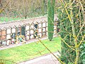
- Cementiri (the town's cemetery)
- Aqüeducte dels Frares (aqueduct of the frays) behind Casa Farguell in the place known as Camí dels Tísics. Built with blind round arches, 120m remaining
- Pont de les Merites de Torà (ancient stone bridge) nearby the cemetery, with a round arch
- Pontet del Diable also called Pontet de la Sentiu, the remains of an aqueduct part of Rec del Moriquers also called Rec d'Ivorra, an acequia (a community-operated waterway) started in 1366, in use until 1920. Outside the town toward the South
- Pou del Gel (an ancient ice well)
Military constructions and buildings
- Castell de l'Aguda (castle): in l'Aguda de Torà (ruins, expoliated)
- Torre de Vallferosa[2] (fortified watchtower): in Vallferosa (highly restored)
- Casa Castell de Llanera (castle-house): in Llanera (fortified manor house, very damaged, expoliated)
Romanesque architecture
- Monestir de Sant Celdoni i Sant Ermenter de Cellers (monastery): with three crossing apses and a crypt, in Cellers
- Església de Claret (church), XII Century (highly reformed)
- Església de Sant Miquel (church): in Fontanet
- Església de Santa Maria de Llanera (church): in Llanera (expoliated)
- Església de Sant Salvador (church): in l'Aguda de Torà
Jewish legacy
- Antic call jueu de Torà (the former Jewish quarter): in Torà's central nucleus
- Location: Carrer Nou, with access through two portals: Portal Nou at Plaça del Pati (Courtyard's Square), and a portal at Plaça de l'Església (Church's Square)[3]
Other monumental buildings
- Convent de Sant Anatoni de Pàdua (a convent devoted to Saint Anthony of Padua), built between 1697 to 1747
- L'Hostal (hostal), still in use
- Església de Santa Maria (church): in Vallferosa (expoliated)
Communications
Torà is along the county road C-1412. Coming from Balaguer, C-1313 towards La Seu d'Urgell until Ponts and then, the road C-1412 towards Calaf. Coming from Cervera, the national road N-141, then the local road LV-3003[4].
| Year | Pop. | ±% |
|---|---|---|
| 1497 | 140 | — |
| 1515 | 92 | −34.3% |
| 1553 | 196 | +113.0% |
| 1717 | 914 | +366.3% |
| 1787 | 1,255 | +37.3% |
| 1857 | 1,969 | +56.9% |
| 1877 | 1,567 | −20.4% |
| 1887 | 1,499 | −4.3% |
| 1900 | 1,303 | −13.1% |
| 1910 | 1,309 | +0.5% |
| 1920 | 1,294 | −1.1% |
| 1930 | 1,567 | +21.1% |
| 1940 | 1,534 | −2.1% |
| 1950 | 1,511 | −1.5% |
| 1960 | 1,442 | −4.6% |
| 1970 | 1,335 | −7.4% |
| 1981 | 1,288 | −3.5% |
| 1990 | 1,181 | −8.3% |
| 1992 | 1,131 | −4.2% |
| 1994 | 1,155 | +2.1% |
| 1996 | 1,143 | −1.0% |
| 1998 | 1,174 | +2.7% |
| 2000 | 1,191 | +1.4% |
| 2002 | 1,220 | +2.4% |
| 2004 | 1,231 | +0.9% |
| 2006 | 1,327 | +7.8% |
| 2009 | 1,367 | +3.0% |
| Source: [5] | ||
Gallery
-
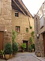 Torà - Street
 -
 Torà in Christmas
 -
-
 Torà - Ca na Núria (Núria's house), Avinguda del Cementiri (Cemetery Av.) and Camí del Pont de Marites (Marites' Bridge's Farm Road)
 -
Torà - Romanesque wood carving. Saint
-
Torà - Romanesque church. Crossing
-
Torà - Romanesque church. Apse
-
Torà - Jewish quarter. Carrer Nou ("New Street")
-
Torà - Jewish quarter.Facade
-
Torà - Jewish quarter. Relief with David's Star
-
Torà - Jewish quarter. High relief with a human face
-
Torà - Portrait of Torà's Giants
-
Torà - Cercavila with Torà's Giants
-
Torà - Dance of the Giants
-
Torà - Close-up shot of the Giants
-
Torà - Bread Museum
-
Torà - Relief with Torà's coat of arms
-
 Torà - Torre de Vallferosa (fortified watchtower)


See also
- Battle of Torà
- Battle of Albesa
- Guissona (closest town to Torà, some 10km away Southwest.)
References
- ^ http://cat.lleida.com/municipi/?municipi=2522340003 Lleida.com
- ^ http://www.vegueries.com/asp/puebloverENG.asp?ID=784 Vegueries .com Routes: Vallferosa (locality in the municipality of Torà), brief description of Vallferosa (Torà) published in the website of a private society specialized in information of touristic interest about routes and places in Catalonia
- ^ http://www.lleidatur.com/cat/culturajueva.html article about Jewish culture at Lleidatur .com, the official website of the Patronat de Turisme de la Diputació de Lleida (the Province's Tourism Administration)
- ^ http://cat.lleida.com/municipi/?municipi=2522340003 Lleida.com
- ^ http://www.idescat.cat/territ/BasicTerr?TC=6&V0=1&CTX=B&ALLINFO=TRUE&V1=25223&VOK=Confirmar idescat: Web de l'estadística oficial de Catalunya
External links
- [1], map of the town of Torà, the nuclear population place.
- [2], map of the municipality of Torà with all the population places.
- Torà .cat, Torà's Town Council's Website.
- Turisme Segarra .com /pobles /Torà (portal de la Segarra a Internet), article with some detailed information about Torà published in the County's Tourism Website.
- Lleidatur .com /cultura jueva article about the Jewish legacy in Torà published in the Province's Tourism Administration's Official Website.
- Lleida .com /municipis, a borough's database.
- APACTorà (Associació del Patrimoni Artístic i Cultural de Torà), a local cultural association.
- Vila de Torà .net, a local popular website.
- Llobregós .net, a website devoted to the Llobregós River Natural Place.
- Vegueries .com Routes: Walk along the town of Torà, article describing Torà's hallmarks of touristic interest published in the website of a private society specialized in information of touristic interest about routes and places in Catalonia.
- Vegueries .com Routes: Torà de Riubregós, a few data about Torà published in the website of a private society specialized in information of touristic interest about routes and places in Catalonia.
- Vegueries .com Routes: Vallferosa (locality in the municipality of Torà), brief description of Vallferosa (Torà) published in the website of a private society specialized in information of touristic interest about routes and places in Catalonia.
- Vegueries .com Routes: "Medieval" bridges: Torà (Le Merite), brief description of an ancient bridge in Torà (XVII to XVIII Centuries) published in the website of a private society specialized in information of touristic interest about routes and places in Catalonia.