
User:Stone Arch Bridge
Stone Arch Bridge | |
|---|---|
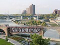
 A view of the Stone Arch Bridge from near river level. | |
| Coordinates | 44°58′51″N 93°15′13″W / 44.98083°N 93.25361°W |
Stone Arch Bridge | |
| Location | Minneapolis, MN |
| Part of | St. Anthony Falls Historic District (ID71000438 [1]) |
| Added to NRHP | March 11, 1971 |
| Carries | Pedestrian and bicycle lanes; formerly two tracks of the Minneapolis, Minnesota |
| Maintained by | Minneapolis Park Board |
| ID number | 27004 |
| Characteristics | |
| Design | 21 stone arch spans, plus one steel-deck truss span |
| Total length | 2100 feet (640 meters) |
| Width | 28 feet (8.5 meters) |
| Longest span | 197.5 feet (60.2 meters) (channel span) |
| Clearance below | 24.4 feet (7.4 meters) |
| History | |
| Opened | 1883 |
| Location | |
 | |
The Stone Arch Bridge is a former railroad bridge crossing the
Positioned between the 3rd Avenue Bridge and the
Heritage trail plaque
A plaque near the bridge explains that the bridge was built for the Manitoba Line (
History
The bridge has been altered somewhat from its original appearance. When the lock and dam was built at Saint Anthony Falls, two of the arches were replaced with a truss so barges could pass through the locks. Later, in 1965, floodwaters undermined three of the piers and caused the bridge to sag. The bridge was repaired by strengthening the piers and reinforcing underneath two of the arches.
When it was in rail service, the bridge carried trains of many railroads to and from the Minneapolis Great Northern Depot, including the Great Northern Railway's Empire Builder. The bridge ceased to be used as a railroad bridge in 1978, and after a period of disuse, was repaired and adapted in the early 1990s to its present use. The bike and walking trails across the bridge are integrated into the city's park and trail system, and form part of the St Anthony Falls Heritage Trail, which includes interpretive plaques describing the history of the area. The most recent renovations—including indirect lighting—were completed in late 2005. The lighting was paid for by private donations.
During the summer months, the Stone Arch Bridge is a focus of numerous festivals in the area of St. Anthony Main and Historic Main Street. The Stone Arch Festival of the Arts occurs
See also
References
- ^ "National Register Information System". National Register of Historic Places. National Park Service. March 15, 2006.
- ^ Brandt, Steve. (May 31, 1989) Star Tribune Hennepin considers buying Stone Arch bridge. Section news; Page 7B
- Olsen, Byron D. (1998). Great Northern Railway 1945-1970 Photo Archive Volume 2. ISBN 1-882256-79-4
- Costello, Mary Charlotte (2002). Climbing the Mississippi River Bridge by Bridge, Volume Two: Minnesota. Cambridge, MN: Adventure Publications. )
Image gallery: the Stone Arch Bridge
-
 The Stone Arch Bridge at dusk
 -
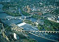 Aerial view of the Stone Arch Bridge below one of the dams that replaced the Saint Anthony Falls
 -
 The Stone Arch Bridge from below
 -
 Perhaps the most striking feature of the bridge is its curvature
 -
 In 1963 the bridge was disfigured to allow clearance for the upper lock
 -
 Segwaytours across the bridge provide easy access
 -
 Below St. Anthony Falls (before 1892)
 -
 Under construction in 1883
 -
 High-res panoramic photo from the new Water Power Park and the lower portion of Saint Anthony Falls
 -
 Mills District lithograph showing the bridge
 -
 Panoramic photo from the ferry
 -
 Stone arch bridge c1905


External links
- Stone Arch Bridge, National Park Service
- Stone Arch Bridge, City of Minneapolis
- James J. Hill Stone Arch Bridge at Structurae
- Photograph
- Stone Arch Festival of the Arts
- Minneapolis-riverfront.com The city's official promotional site for the riverfront district.
- Yesterday's News blog Nov. 24, 1883: A Minneapolis newspaper account of the bridge's opening.
- Minnesota Department of Transportation (Mn/DOT) Historic Bridge Management Plan, Bridge 27004
Bridges of the Mississippi River | ||||
|---|---|---|---|---|
| ||||
| Topics | |
|---|---|
| Lists by state |
|
| Lists by insular areas | |
| Lists by associated state | |
| Other areas | |
| Related | |
Category:Bridges completed in 1883 Category:Bridges in Minneapolis, Minnesota Category:Bridges on the National Register of Historic Places in Minnesota Category:Bridges over the Mississippi River Category:Cyclist bridges Category:Deck arch bridges Category:Former railway bridges in the United States Category:Great Northern Railway (U.S.) bridges and tunnels Category:Historic Civil Engineering Landmarks Category:Mississippi National River and Recreation Area Category:National Register of Historic Places in Minneapolis, Minnesota Category:Pedestrian bridges in Minnesota Category:Railroad bridges in Minnesota Category:Railway bridges on the National Register of Historic Places Category:Stone bridges Category:Viaducts in the United States