Víðgelmir

Coordinates: 64°45′01″N 20°48′06″W / 64.750283°N 20.801700°W / 64.750283; -20.801700
Source: Wikipedia, the free encyclopedia.
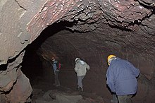
Víðgelmir in Iceland - Expeditioners are walking on top of a "pipe" formed when half molten lava "skin" rolled down the walls when the eruption receded.
Víðgelmir has many ice-formations deep within the cave.

Víðgelmir (Icelandic pronunciation:

speleothems which hadn't already been destroyed. Evidence of human habitation, probably dating to the Viking Age, has been discovered in the cave and is preserved in the National Museum of Iceland
. Long stretches of the cave floor are very rough and shouldn't be navigated without a guide. Access and guided tours are provided at nearby Fljótstunga.

Lava tubes are formed when a low-viscosity lava flow develops a continuous and hard crust which then thickens and forms a roof above the molten lava stream. When the eruption subsides, the still-molten lava moving beneath the crust will continue to drain downhill, leaving an open lava tube.[2] Many other lava tubes have been discovered in Hallmundarhraun, most notably Surtshellir and Stefánshellir.

References

  1. ^ "Víðgelmir Cave". Archived from the original on 2011-07-04. Retrieved 2007-09-11.
  2. ^ "Birth of Lava Tubes". Retrieved 2011-07-02.

64°45′01″N 20°48′06″W / 64.750283°N 20.801700°W / 64.750283; -20.801700

External links