
Val Medel
This article includes a improve this article by introducing more precise citations. (November 2018) ) |

The Val Medel (
The lower 3 kilometers (1.9 mi) of the valley contains a narrow gorge, known as the Medelserschluch or Las Ruinas, which widens to the green and fertile Trog valley at the village of Curaglia.
Settlements
The only municipality in the valley is Medel, which encompasses the numerous villages, hamlets and isolated settlements on both sides of the valley. The largest and most northerly village is Curaglia. Other settlements are (from north to south) Mutschnengia, Platta, Pardes, and Fuorns Acla. The whole municipality stretches over 136 square kilometers (53 sq mi), of which over 136 km2 (53 sq mi) is unproductive.
Language and religion
An intermediate form between the
Waters
The river Froda flows through the uppermost portion of the valley. It begins in the Lai da Sontga Maria reservoir. At the hamlet of Pardatsch (1,559 m (5,115 ft)), the Froda merges with the Rein da Cristallina (which emerges from the Val Cristallina), to form the
Side Valleys
At Curaglia the Val Plattas branches off to the south east. Near Pardatsch, the Val Cristallina branchess off, also to the south east.
Gallery
-
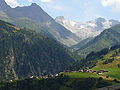 Views of the Val Plattas, with the Piz Medel the middle and the village of Medel in front of Val Plattas
 -
 Curaglia, in the background Disentis Abbey
 -
 Southern part of the valley at Sogn Gagl
 -


External links
- Official website of the municipality
- Val Medel
- Val Medel in 1615.php German, 1615.php French and 1615.php Italian in the online Historical Dictionary of Switzerland.