
Valapattanam
Valapattanam | |
|---|---|
UTC+5:30 (IST) | |
| ISO 3166 code | IN-KL |
| Vehicle registration | KL-13 |
.jpg)
.jpg)

Valapattanam is a census town and a suburb of Kannur city in the
Etymology
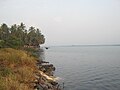
This town is also known as Balyapattanam. This town is situated on the banks of the
History
This town is named after its historical founder Vallabha II of the
Commerce
Western India Plywoods Ltd., the largest wood-based industry in the country and once Asia's biggest plywood factory is located on the bank of Valapattanam River. Apart from the dense presence of booming plywood and timber based industries, Valapattanam has small scale sand mining and fisheries activities. Warehouses of many prominent industries in Kannur is situated at Valapattanam.
Religion
Known for its communal harmony and tradition of peaceful coexistence, numerous religious centers with centuries of tradition is located here.
The
Geography
Valapattanam is located at 11°54′N 75°22′E / 11.9°N 75.37°E.[6] It has an average elevation of 6 metres (19 feet).
Suburbs and villages
- Manna, Valappattanam
.jpg)
Demographics
The Valapattanam Census Town has population of 7,955 of which 3,677 are males while 4,278 are females as per report released by Census India 2011.
Children aged 0 to 6 years number 1077, which is 13.54 % of the population. The female sex ratio is 1163[clarification needed] against state average of 1084. The child sex ratio is around 962 compared to Kerala state average of 964. Literacy rate of Valapattanam city is 95.43%, higher than state average of 94.00%. The male literacy is around 97.15% while female literacy rate is 94.00%.
Valapattanam census town has total administration over 1,329 houses to which it supplies basic amenities like water and sewage. It is also authorize to build roads within census town limits and impose taxes on properties coming under its jurisdiction.[7]
Images
-
 Village footpath
 -
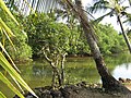 Coconut in serenity
 -
 Poithum Kadavu
 -
 Kaliyattam at Valapattanam


Valapattanam Panchayath is rated among the best panchayaths in Kerala. The development activities of the panchayat has been commended by both the district and state authorities, as well as the public at large.
See also
- Muthappan temple
- Sree Muthappan
- Kannur
References
- ^ https://www.citypopulation.de ›
- ^ https://www.citypopulation.de ›
- ^ Ezhimala: the abode of the Naval Academy by Murkot Ramunny in 1993, Northern Book Centre, New Delhi
- ^ The Rehla of Ibn Battuta (India, Maldive Islands and Ceylon), tr. and commentary by Mahdi Husain (Baroda: Oriental Institute, 1953), 186.
- ISBN 9780143066491.
- ^ Falling Rain Genomics, Inc - Valapattanam
- ^ https://dop.lsgkerala.gov.in › node