
Vals Valley
The Vals Valley (
Graubünden in Switzerland
.

Geography
The Vals Valley is a roughly 16 kilometers long valley. At Uors, it branches off to the south from the Lumnezia. The valley is drained by the Valser Rhine. There are two municipalities in the valley: Vals and St. Martin.
The population is spread out across several hamlets and the village of Vals-Platz, which has an altitude of 1250 m. They form a Walser enclave, since the people in the adjacent Lumnezia speak Romansh.
History
Isolated finds show that the Vals Valley was used as a link between the
Alpine Rhine Valley as early as the Bronze Age
.
The lower part of the valley was settled in the 12th Century, if not earlier.
Walser
migration.
Tourism
Therme Vals, the only hot spring in Graubünden where hot water springs straight from the ground, is located in the valley. Peiden-Bad, in the Lumnezia, is a former spa
.
Gallery
-
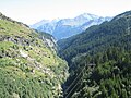 Upper Vals Valley
 -
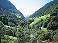 Vals Valley
 -
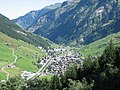 The village Vals


46°41′55″N 9°10′54″E / 46.698729°N 9.181566°E