
Valtournenche
This article needs additional citations for verification. (December 2009) |
Valtournenche
Vótornéntse | |
|---|---|
| Comune di Valtournenche Commune de Valtournenche | |
 | |
.svg) Coat of arms | |
Location of Valtournenche  | |
UTC+2 (CEST) | |
| Postal code | 11028 |
| Dialing code | 0166 |
| Website | http://www.comune.valtournenche.ao.it |
Valtournenche (local
Valdôtain: Vótornéntse) is a town and comune in the Aosta Valley region of north-western Italy, 1,500 m (4,900 ft) above the sea level. It is named after and covers the upper side of the Valtournenche, a valley on the left side of the Dora Baltea, from Châtillon to the Matterhorn. Valtournenche municipality includes Breuil-Cervinia, whose ski resort is linked to Zermatt, Switzerland.[4]
History
This section is empty. You can help by adding to it. (March 2020) |
Notable people
- Jean-Antoine Carrel (1829–1890), mountain climber
- Jean-Joseph Maquignaz (1829–1890), mountain climber
- Georges Carrel (1800–1870), canon, mountain climber and botanist
- Luigi Carrel (1901–1983), mountain climber
- Piero Maquignaz, skier and mountain climber
-
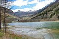 The Maën lake
 -
 Maën lake seen from Pâquier


References
- ^ "Arrêté n° 479 du 21 septembre 2023 / Decreto 21 settembre 2023, n. 479" (PDF). Bollettino Ufficiale della Regione Autonoma Valle d’Aosta / Bulletin Officiel de la Région autonome Vallée d’Aoste. Regione Autonoma Valle d'Aosta / Région Autonome Vallée d'Aoste. p. 3433. Retrieved 2024-02-09.
- ^ "Superficie di Comuni Province e Regioni italiane al 9 ottobre 2011". Italian National Institute of Statistics. Retrieved 16 March 2019.
- ^ "Popolazione Residente al 1° Gennaio 2018". Italian National Institute of Statistics. Retrieved 16 March 2019.
- ^ "Valtournenche". Cervinia Ski Paradise. Cervinia. Retrieved 11 October 2018.

This article on a location in Aosta Valley is a stub. You can help Wikipedia by expanding it. |