
Vihorlat Protected Landscape Area
| Vihorlat Protected Landscape Area CHKO Vihorlat | |
|---|---|
IUCN category V (protected landscape/seascape) | |
 | |
| Location | Eastern Slovakia |
| Coordinates | 48°55′N 22°10′E / 48.917°N 22.167°E |
| Area | 174.85 km² (67.5 mi²) |
| Established | 28 December 1973 |
| Governing body | Správa CHKO Vihorlat (Vihorlat PLA administration) in Michalovce |
_046.jpg)
Vihorlat Protected Landscape Area (Slovak: Chránená krajinná oblasť Vihorlat) is one of 14 protected landscape areas in Slovakia. The Landscape Area is in the middle part of the Vihorlatské vrchy mountains, in eastern Slovakia. It is in the Humenné, Sobrance and Snina districts.
History
The park was created on 28 December 1973 and the law creating it was amended on 19 April 1999.
Geography, geology and biology
The area of the Vihorlat Mountains is of volcanic origin.
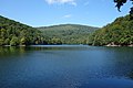
gray wolf, otter, black stork, Ural owl, lesser spotted eagle, and Eurasian eagle-owl.[1] A curiosity in the park is the Morské oko
(literally 'Sea Eye') Lake.
Gallery
-
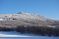 Vihorlat (1,076 m), the highest mountain of Vihorlat Mountains
 -
 Pylon on top of Vihorlat with rime
 -
 Winter in Vihorlat (left peak Kyjov)
 -
 Vihorlat in winter, in the background High Tatras
 -
 Sninský kameň (1,006 m)
 -
 View of Morské oko from Sninský kameň
 -
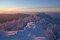 Sninský kameň in winter at sunset
 -
 Sninský kameň in autumn
 -
 Morské oko and peak Sninský kameň
 -
 Morské oko in May
_002.jpg)
_007.jpg)
_025.jpg)
_034.jpg)
_015.jpg)
_026.jpg)
_046.jpg)


_008.jpg)
See also
References
- ^ "Správa CHKO Vihorlat (in Slovak)". Štátna ochrana prírody SR. n.d. Retrieved May 24, 2007.
External links
- Chránená krajinná oblasť Vihorlat (in Slovak)
- Photo gallery Vihorlat, Photo gallery Sninský kameň, Photo gallery Inversion – Vihorlat, Sninský kameň (photos of Vihorlat and Sninský kameň)
- Vihorlat PLA at Slovakia.travel
- Vihorlat PLA at The Slovak State Nature Conservancy
| Authority control databases: National |
|---|