
Vostok Island
 Vostok Island | |
 Map of the Line Islands | |
 Vostok Island  Vostok Island  Vostok Island | |
| Geography | |
|---|---|
| Location | South Pacific Ocean |
| Coordinates | 10°03′43″S 152°18′46″W / 10.06194°S 152.31278°W |
| Archipelago | Line Islands |
| Area | 0.24 km2 (0.093 sq mi) |
| Length | 0.7 km (0.43 mi) |
| Width | 0.6 km (0.37 mi) |
| Highest elevation | 5 m (16 ft) |
| Administration | |
| Demographics | |
| Population | 0 |
| Additional information | |
| Time zone | |
Vostok Island is an uninhabited coral island in the central Pacific Ocean, part of the Line Islands belonging to Kiribati. Other names for the island include Anne Island, Bostock Island, Leavitts Island, Reaper Island, Wostock Island or Wostok Island. The island was first sighted in 1820 by the Russian explorer Fabian Gottlieb von Bellingshausen, who named the island for his ship Vostok.[a]
Geography, flora and fauna

Vostok covers a land area of 24 hectares (59 acres). Its nearest neighbors are
Beaches on the island range between 25 and 30 metres (82 and 98 feet) wide, composed of coral sand and rubble. There is no lagoon or fresh water on the island, and no known
The herbs Boerhavia repens and Sesuvium portulacastrum round out the known vegetation.[5] Although coconut seedlings were planted on Vostok in 1922 they failed to grow despite being successfully cultivated on the nearby islands of Caroline and Flint.[2]
Noteworthy fauna includes several species of seabirds, including the
History
The island was first sighted in 1820 by the Russian explorer
Vostok formed part of the British
Vostok Island is designated as the Vostok Island Wildlife Sanctuary.[8][9] In 2014 the Kiribati government announced the establishment of a 12-nautical-mile fishing exclusion zone around each of the southern Line Islands (Caroline, Flint, Vostok, Malden, and Starbuck).[10]
Its isolated nature means it is rarely visited, save by the occasional scientist or yachter.
Photo gallery
-
 Wind-shorn Pisonia trees on Vostok Island
 -
 Virgin forest of Pisonia trees covering Vostok Island
 -
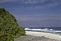 Western coastline of Vostok Island


See also
- List of Guano Island claims
- List of islands
- Desert island
References
Notes
References
- ^ S2CID 129664580.
- ^ a b c Resture, Jane. "Vostok Island, Line Islands". janeresture.com. Retrieved 15 May 2015.
- ^ . Retrieved 27 October 2021.
- ^ The mystery behind Google Maps' 'black hole' in the Pacific Ocean, BBC, 5 Nov 2021
- ^ Watkins, Doug; Batoromaio, Kiritian (2014). "Directory of Wetlands of Kiribati - 2014" (PDF). SPREP. p. 87. Retrieved 27 October 2021.
- ^ a b "Vostok Island's History Is Yet To Be Made". Pacific Islands Monthly. Vol. 37, no. 9. 1 September 1966. pp. 86–87. Retrieved 27 October 2021 – via National Library of Australia.
- ^ US Department of State Background Note
- ^ Edward R. Lovell, Taratau Kirata & Tooti Tekinaiti (September 2002). "Status report for Kiribati's coral reefs" (PDF). Centre IRD de Nouméa. Retrieved 15 May 2015.
- ISBN 978-0-8248-1217-1.
- ^ a b Warne, Kennedy (September 2014). "A World Apart – The Southern Line Islands". National Geographic. Archived from the original on 21 August 2017. Retrieved 15 May 2015.
External links
- National Geographic - Southern Line Islands Expedition, 2014 Archived 2017-08-21 at the Wayback Machine
- Article at Jane's Oceania Home Page - includes a sketch map
- Article at Looking For Nemo Expedition's site - includes photo and sketch map
- Oceandots - Vostok Island at the Wayback Machine (archived December 23, 2010) - satellite photograph
| Gilbert Islands |  | |
|---|---|---|
| Phoenix Islands | ||
| Line Islands | ||
| West of Gilberts | ||
| Reefs | ||
| ||
| International | |
|---|---|
| National | |