
Wadi Musa
Wadi Musa
وادي موسى | |
|---|---|
Town | |
 | |
 Wadi Musa | |
| Coordinates: 30°19′12″N 35°28′42″E / 30.32000°N 35.47833°E | |
| Country | Jordan |
| Province | Ma'an Governorate |
| Area | |
| • Total | 7.36 km2 (2.84 sq mi) |
| (excludes Al Hayy, an undeveloped residential zone) | |
| Elevation | 1,050−1,450 m (−3,700 ft) |
| Population (2015)[2] | |
| • Total | 6,831 |
| • Density | 930/km2 (2,400/sq mi) |
| Time zone | GMT +2 |
| • Summer (DST) | +3 |
| Area code | +(962)3 |
Wadi Musa (
Etymology
Wadi Musa means "Valley of Moses" in Arabic. It is said that
History
During the
During the
The Jordanian census of 1961 found 654 inhabitants in Wadi Musa.[9]
Climate
In Wadi Musa, there is a semi-arid climate. Most rain falls in the winter. The Köppen-Geiger climate classification is BSk. The average annual temperature in Wadi Musa is 15.5 °C (59.9 °F). About 193 mm (7.60 in) of precipitation falls annually.
| Climate data for Wadi Musa | |||||||||||||
|---|---|---|---|---|---|---|---|---|---|---|---|---|---|
| Month | Jan | Feb | Mar | Apr | May | Jun | Jul | Aug | Sep | Oct | Nov | Dec | Year |
| Mean daily maximum °C (°F) | 11.0 (51.8) |
13.1 (55.6) |
16.6 (61.9) |
20.9 (69.6) |
25.1 (77.2) |
28.6 (83.5) |
29.8 (85.6) |
30.0 (86.0) |
28.1 (82.6) |
24.6 (76.3) |
18.2 (64.8) |
13.4 (56.1) |
21.6 (70.9) |
| Mean daily minimum °C (°F) | 2.2 (36.0) |
2.8 (37.0) |
5.6 (42.1) |
8.7 (47.7) |
11.7 (53.1) |
14.1 (57.4) |
16.1 (61.0) |
16.5 (61.7) |
14.2 (57.6) |
11.2 (52.2) |
7.1 (44.8) |
3.4 (38.1) |
9.5 (49.1) |
| Average precipitation mm (inches) | 45 (1.8) |
38 (1.5) |
36 (1.4) |
12 (0.5) |
4 (0.2) |
0 (0) |
0 (0) |
0 (0) |
0 (0) |
2 (0.1) |
15 (0.6) |
41 (1.6) |
193 (7.6) |
| Source: Climate-Data.org,Climate data | |||||||||||||
Demographics
As of 2009, Wadi Musa's population was 17,085, with a
Most of the town's population belongs to the Layathnah tribe, whose members play leading roles in the region's economy and politics and dominate the local tourism industry since the 20th century. Almost the entire population is
Economy
The town is about 250 kilometres (160 mi) from Amman, Jordan's capital, and 100 kilometres (60 mi) north of the port city of Aqaba. With more than 50 hotels and many tourist restaurants, its economy is almost entirely tied to tourism.
The campus of the College of Archaeology, Tourism & Hotel Management of Al-Hussein Bin Talal University is located in Wadi Musa.
Gallery
-
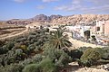
 Wadi Musa Valley
 -
 Petra Visitors Center
 -
 Townscape
 -
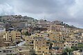 Houses in Wadi Musa
 -
 Wadi Musa at dusk
 -
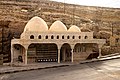 Moses source
 -
 Hotel
Hotel -
 Mountains


.jpg)


References
- ^ a b c d e "The Strategic Master Plan for the Petra Region: Strategic Plan for WADI MUSA and surrounding areas" (PDF). Petra Development and Tourism Region Authority. June 2011. Archived (PDF) from the original on 9 August 2016. Retrieved 5 June 2016.
- ^ "The General Census - 2015" (PDF). Department of Population Statistics.
- ^ "Wadi Musa". Lonely Planet. Retrieved 25 October 2022.
- ^ "Wadi Musa town". Rough Guides. Retrieved 25 October 2022.
- ^ "Wadi Musa". Tourist Jordan. Retrieved 24 October 2022.
- ^ Corbett, Glenn J. (4 November 2021). "Solving the Enigma of Petra and the Nabataeans". Biblical Archaeology Society. Retrieved 24 October 2022.
- ISBN 9780300226393.
- ^ Lawrence, T.E. (1935). Seven Pillars of Wisdom. Garden City: Doubleday, Doran & Company, Inc. p. 381.
- ^ Government of Jordan, Department of Statistics, 1964, p. 22
- ^ "Table 3.1 Distribution of Population by Category, Sex, Nationality, Administrative Statistical Divisions and Urban - Rural" (PDF). Population and Housing Census 2004. Department of Statistics. Archived from the original (PDF) on 22 July 2011. Retrieved 5 June 2016.
Bibliography
- Government of Jordan, Department of Statistics (1964). First Census of Population and Housing. Volume I: Final Tables; General Characteristics of the Population (PDF).
External links
- Photos of Wadi Musa at the American Center of Research
- Photos of Wadi Musa at the Manar al-Athar photo archive
| International | |
|---|---|
| National | |