
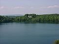
Weinfelder Maar
| Weinfelder Maar | |
|---|---|
Daun, Eifel | |
| Coordinates | 50°10′35″N 6°51′1″E / 50.17639°N 6.85028°E |
| Basin countries | Germany |
| Max. length | 525 m (1,722 ft) |
| Max. width | 375 m (1,230 ft) |
| Surface area | 16.8 ha (42 acres) |
| Max. depth | 51 m (167 ft) |
| Surface elevation | 483.5 m (1,586 ft) |
The Weinfelder Maar, also called the Totenmaar, is a

Geography
The maar lake was formed about 10,500 years ago by a
Name

The description "Totenmaar" ("maar of the dead") comes from the cemetery in the immediate vicinity of the maar with its little chapel, parts of which date to the 14th century. This was the old parish church of Weinfeld. The village was abandoned in the 16th century (it was last mentioned in 1512) in the wake of the Plague.
The chapel and attached cemetery are used today for burials by the municipality of Schalkenmehren. In the entrance way of the chapel are numerous Dank-Tafeln, plaques with inscriptions such as "[Saint] Mary has helped".
Legends
There are several legends associated with the tranquil Totenmaar. According to one, a castle once stood on this spot in which a benevolent count lived with his servants, his hard-hearted wife and his only child. One day, the count returned home from the hunt and found only a lake in the place where his castle had stood. It was buried in the ground with all its inhabitants and had left behind a lake, the Totenmaar. Miraculously a cradle appeared on the surface, in which his child drifted safely to shore. The count's horse scraped a spring from the ground at the behest of his master. Later, out of gratitude for the salvation of his child, the count built a chapel, which is still preserved along with the spring.
_b_179.jpg)
Gallery
- Ansichten
-
 In summer
 -
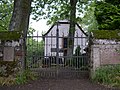
 The chapel by the maar
 -
 View from the cemetery
 -
 Weinfeld church and view of the cemetery
 -
 In late summer
 -
 In early summer
 -
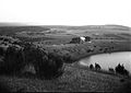 Between 1895 and 1904


See also
References
Literature
- Werner P. d´Hein: Nationaler Geopark Vulkanland Eifel. Ein Natur- und Kulturführer. Gaasterland-Verlag, Düsseldorf, 2006, ISBN 3-935873-15-8