Wellow, Somerset

Coordinates: 51°19′25″N 2°22′25″W / 51.3236°N 2.3737°W / 51.3236; -2.3737
Source: Wikipedia, the free encyclopedia.

Wellow
Avon and Somerset
FireAvon
AmbulanceSouth Western
UK Parliament
List of places
UK
England
Somerset
51°19′25″N 2°22′25″W / 51.3236°N 2.3737°W / 51.3236; -2.3737

Wellow is a village and

Conservation Area in 1983.[2]

History

Wellow Brook

There is a

A little further west is the

ammonite
decorating the left-hand doorjamb. The site was excavated by
John Skinner in 1816-17 who gained the entry through a hole originally made about 1760. The excavation revealed the bones (some burned) of several individuals.[6]

The parish gave its name to the

Hundred.[7]

On 26 June 1685 the

Norton St. Philip after failing to advance into Bristol and Bath. Their exact route is subject to conjecture, but it is widely assumed that they would have taken their heavy cannons via the Wellow and Norton Brook valleys rather than tackling the steep ascent to Hinton Charterhouse
, and that Baggridge would have been used as a vantage point for surveying the route ahead.

In the 1880s and 1890s a small mine extracting and drying Fuller's earth was situated between Wellow and Stoney Littleton and also beside Hassage Hill and Bath Hill linked to the roads by short tramways.[8] The existence of Fullers Earth around Wellow has caused several collapses of local roads and has been used for forensic identification of a vehicle in a murder enquiry.

In World War II the Wellow valley became part of the GHQ stop line green, with defences intended to isolate southern England in the event of German invasion. The remains of a number of type 24 pillboxes and anti-tank cubes can be found in various riverside locations both upstream and downstream of the village.
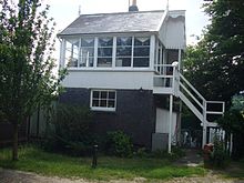
Disused signal box on the Somerset and Dorset Joint Railway, now privately owned

Wellow Station, on the Somerset and Dorset Joint Railway, opened in 1874 and closed in 1966. The station building was converted into a house by the artist Peter Blake and his then wife Jann Haworth, in the mid-1970s. The railway followed the route of the Radstock arm of the Somerset Coal Canal. Although the Camerton branch of the canal was very successful, the Radstock branch was not, mainly because its connection to the main line at Midford involved transhipment via a tramway, and it carried very little traffic. The canal was mainly obliterated by the railway although a sharp bend (still in water) at St Julian's Well, and a tunnel, were bypassed by the viaduct over the foot of Bull's Hill. The railway trackbed East of the village is now part of national cycle route NCR 24, the Colliers Way. From April 2013 the route has a level connection beyond Midford to Bath via the Two Tunnels Greenway. This project was partially funded by auctioning King Bladud's pigs, 104 sculptures decorated by different artists, which were exhibited throughout the Bath area in 2008. Wellow hosted several pigs, including the most expensive of all which was decorated by Peter Blake and housed in the village pub, the Fox and Badger. The cycle route continues westward via Wellow High Street and minor roads to Stoney Littleton and Shoscombe before rejoining the former railways to Radstock and Frome
.

Governance

The

, as well as consulting with the unitary council on the maintenance, repair, and improvement of highways, drainage, footpaths, public transport, and street cleaning. Conservation matters (including trees and listed buildings) and environmental issues are also of interest to the council.

Pig sculpture in the centre of the village

The parish falls within the

Avon and Somerset Constabulary and the Great Western Ambulance Service
.

Between 1974 and 1996 Bath and North East Somerset carried out district council functions only, county council services being provided by Avon County Council. Before 1974 the parish was part of the Bathavon Rural District of Somerset.[9]

The parish falls within the constituency of

MEPs
.

Geography

Fox and Badger pub

Nearby are the Hinton Hill and Cleaves Wood sites of Special Scientific Interest.

Cam Brook at Midford to form Midford Brook which joins the River Avon close to the Dundas Aqueduct
.

Hinton Hill is of importance to studies of the stratigraphy of the Middle Jurassic of the Bath district, and the British Bathonian as a whole.[10]

Xanthogramma citrofasciatum, and a number of beetle species.[11]

Religious sites

Wellow Church

The parish

transom to west. It is a Grade I listed building.[14]

References

  1. ^ a b "Wellow Parish". Neighbourhood Statistics. Office for National Statistics. Retrieved 31 December 2013.
  2. ^ "Wellow Conservation Area Character Appraisal". Bath and North East Somerset Council. Archived from the original on 21 October 2007. Retrieved 14 January 2008.
  3. ^ "Packhorse Bridge over Wellow Brook". historicengland.org.uk. Retrieved 8 October 2006.
  4. .
  5. ^ "Stoney Littleton Long Barrow". Scheduled Monument Record. Bath and North East Somerset. Archived from the original on 18 September 2010. Retrieved 3 October 2010.
  6. ^ "Stoney Littleton". Stones of England. Retrieved 15 March 2008.
  7. ^ "Somerset Hundreds". GENUKI. Retrieved 22 October 2011.
  8. .
  9. ^ "Bathavon RD". A vision of Britain Through Time. University of Portsmouth. Retrieved 4 January 2014.
  10. ^ English Nature citation sheet . Retrieved 12 July 2006.
  11. ^ a b English Nature citation sheet for the site. Retrieved 16 July 2006.
  12. page 252
  13. page 247
  14. ^ "Parish Church of St Julian, Wellow". historicengland.org.uk. Retrieved 8 October 2006.

External links