
Wolverine, Michigan
Wolverine, Michigan | ||
|---|---|---|
FIPS code 26-88240[4] | | |
| GNIS feature ID | 1616712[3] | |
| Website | Official website | |
Wolverine is a village in
The village is mostly located within Nunda Township with a small portion extending west into Wilmot Township. It is located directly west of Interstate 75 about 40 miles (64.4 km) south of the Mackinac Bridge.
History
The area was originally settled by Jacob Shook and his family as early as 1874. The community was named "Torrey" when George Richards settled in the area soon after. Venturing to the area was difficult, as the nearest railway line ended in Gaylord about 20 miles (32.2 km) to the south. Richards was a frequent traveler back and forth to Gaylord for mail and supplies, often staying mid-route at Vanderbilt. He requested a closer post office, which was granted under the name Wolverine in late 1880.
The post office was first established on January 3, 1881, and continues to remain in operation.[6] Richards served as the first postmaster. As an early settler of the community, he helped organize and operate the local school district and was also a real estate dealer and lumberman. He was elected to the Michigan House of Representatives in 1903.
In 1881, Wolverine recorded 18 residents. Soon after, the Jackson, Lansing, and Saginaw Railroad Company received a deed and began railway construction at the community of Trowbridge about 5 miles (8.0 km) to the southeast. By 1891, the population of Wolverine increased to about 1,000 residents, who mainly worked for the railway and lumbering industry. The community incorporated as a village in 1903. By 1905, the area population was around 1,800. When the lumber industry declined by the 1930s, the population drastically decreased as many people left Wolverine.[7]
Geography
According to the U.S. Census Bureau, the village has a total area of 0.99 square miles (2.56 km2), of which 0.98 square miles (2.54 km2) is land and 0.01 square miles (0.03 km2) (1.01%) is water.[5]
Wolverine is situated on the Sturgeon River where the west branch joins the main branch at 45°16′24″N 84°36′16″W / 45.27333°N 84.60444°W.
Wolverine contains its own post office using the 49799 ZIP Code, which is the highest numeric ZIP Code in the state's Lower Peninsula. The Wolverine post office serves a much larger area that includes most of Nunda Township and Wilmot Township, as well as smaller portions of Ellis Township and Mentor Township. The post office also serves a very small portion of Corwith Township in Otsego County to the south, as well as very small portions of Chandler Township in Charlevoix County and Springvale Township in Emmet County to the west.[8][9]
Demographics
| Census | Pop. | Note | %± |
|---|---|---|---|
| 1910 | 794 | — | |
| 1920 | 413 | −48.0% | |
| 1930 | 300 | −27.4% | |
| 1940 | 257 | −14.3% | |
| 1950 | 318 | 23.7% | |
| 1960 | 292 | −8.2% | |
| 1970 | 303 | 3.8% | |
| 1980 | 364 | 20.1% | |
| 1990 | 283 | −22.3% | |
| 2000 | 359 | 26.9% | |
| 2010 | 244 | −32.0% | |
| 2020 | 309 | 26.6% | |
| U.S. Decennial Census[10] | |||
2010 census
As of the
There were 94 households, of which 37.2% had children under the age of 18 living with them, 51.1% were married couples living together, 12.8% had a female householder with no husband present, 4.3% had a male householder with no wife present, and 31.9% were non-families. 25.5% of all households were made up of individuals, and 14.9% had someone living alone who was 65 years of age or older. The average household size was 2.60 and the average family size was 3.14.
The median age in the village was 40.3 years. 27% of residents were under the age of 18; 4.9% were between the ages of 18 and 24; 23.7% were from 25 to 44; 28.7% were from 45 to 64; and 15.6% were 65 years of age or older. The gender makeup of the village was 46.3% male and 53.7% female.
2000 census
As of the
There were 131 households, out of which 35.1% had children under the age of 18 living with them, 46.6% were married couples living together, 16.8% had a female householder with no husband present, and 29.8% were non-families. 25.2% of all households were made up of individuals, and 7.6% had someone living alone who was 65 years of age or older. The average household size was 2.74 and the average family size was 3.27.
In the village, the population was spread out, with 30.9% under the age of 18, 8.9% from 18 to 24, 27.6% from 25 to 44, 22.3% from 45 to 64, and 10.3% who were 65 years of age or older. The median age was 32 years. For every 100 females, there were 84.1 males. For every 100 females age 18 and over, there were 87.9 males.
The median income for a household in the village was $22,813, and the median income for a family was $26,500. Males had a median income of $27,500 versus $17,250 for females. The
Images
-
 Village office and library
 -
 U.S. Post Office in Wolverine
 -
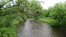 Sturgeon River flowing through Wolverine
 -
 Michigan Central Depot in 1920
 -
 Michigan Central Depot in 2021


.jpg)
_1920.png)
.jpg)
References
- ^ Village of Wolverine (2021). "Wolverine: Board Members". Retrieved June 8, 2021.
- ^ "2020 U.S. Gazetteer Files". United States Census Bureau. Retrieved May 21, 2022.
- ^ a b U.S. Geological Survey Geographic Names Information System: Wolverine, Michigan
- ^ a b "U.S. Census website". United States Census Bureau. Retrieved January 31, 2008.
- ^ 2010 United States Census. United States Census Bureau. September 2012. p. 18 Michigan. Archived(PDF) from the original on October 19, 2012. Retrieved June 7, 2021.
- ^ U.S. Geological Survey Geographic Names Information System: Wolverine, Michigan
- ^ Village of Wolverine (2021). "History of Wolverine". Retrieved June 19, 2021.
- ^ UnitedStatesZipCodes.org (2021). "ZIP Code 49799: Wolverine". Retrieved June 17, 2020.
- ^ Google (June 17, 2021). "49799 ZIP Code map" (Map). Google Maps. Google. Retrieved June 17, 2021.
- ^ "Census of Population and Housing". Census.gov. Retrieved June 4, 2015.
- ^ "U.S. Census website". United States Census Bureau. Retrieved November 25, 2012.
Municipalities and communities of Cheboygan County, Michigan, United States | ||
|---|---|---|
| City |  | |
| Villages | ||
| Civil townships | ||
| CDPs |
| |
| Other communities | ||
| Indian reservations | ||
| Footnotes | ‡This populated place also has portions in an adjacent county or counties | |
| ||
| International | |
|---|---|
| National | |