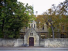
Woodstock Road, Oxford
Appearance


Grade II listed
apartment block, on Woodstock Road.Woodstock Road is a major road in
St Giles' in the south, north towards Woodstock through the leafy suburb of North Oxford.[1] To the east is Banbury Road
, which it meets at the junction with St Giles'.
Buildings
At the southern end, just north of
SIX TV
.
The road is classified
A4144
.
Notable residents
Former residents include:[3]
- Merton Professor of English Language and Literature at the University of Oxford
- Sir Hugh Elliott, OBE (1913–1989), ornithologist
- CBE (1906–1982), civil servant, diplomat, and Master of University College, Oxford, and Lady Redcliffe-Maud(1904–1993), pianist
- Egon Wellesz, CBE (1885–1974), composer and musicologist
- Rowan Atkinson and Richard Curtis, lived together as students[4]
- Dorothy Hodgkin, chemist, awarded a Nobel Prize for advances in protein crystallography, lived at 94 Woodstock Road from 1957 to 1968[5]
- Bill Clinton lived on Leckford Road, just off Woodstock Road, during his time as a student at Oxford.
Adjoining roads in North Oxford
- Banbury Road
- Bainton Road
- Beech Croft Road
- Bevington Road
- Blandford Avenue
- Canterbury Road
- Farndon Road
- Frenchay Road
- Lathbury Road
- Leckford Road
- Little Clarendon Street
- Moreton Road
- Observatory Street
- Plantation Road
- Polstead Road
- Rawlinson Road
- St Bernard's Road
- St Giles' Street, Oxford
- St Margaret's Road
- South Parade
- Staverton Road
See also
References
- ISBN 0-300-05184-0.[page needed]
- ^ Woodstock Road Baptist Church, Oxford, England.
- Kelly's Directories. 1976. pp. 481–484.
- ^ "Rowan Atkinson, Desert Island Discs - BBC Radio 4". BBC. Retrieved 20 March 2017.
- ^ "Blue plaque unveiled honouring Dorothy Hodgkin (1910–1994)". June 2016.
