
John Street (Hamilton, Ontario)

John Street is a Lower City arterial road in Hamilton, Ontario, Canada. Originally it was known as Mountain Road or Ancaster Road. It starts off at the base of Arkledun Avenue, a Mountain-access road in the city, just east of St. Joseph's Hospital, where it is a one-way street going north and tunnels underneath the Hunter Street Railway bridge and continues onward to the city's North End at the waterfront, where it ends at Guise Street East, the site of Pier 9.
History
Talk of creating a townsite at what is now the intersection of John and Main streets arose as early as 1809, but the war delayed the scheme until 1816 when George Hamilton and Nathaniel Hughson successfully promoted Hamilton as the judicial centre for the counties of Halton and Wentworth (the Gore District).[1]

When the Town of Hamilton was incorporated in 1833, one of the first orders of business was to find a suitable place for the town board to meet. For the first few years they made do with meeting in local taverns such as Thomas Wilson's Inn on the corner of John and Jackson Streets.[2]
John Street is also one of the original native pathways in the area. In 1837, the police commission officially named it John Street - a name originally chosen by George Hamilton (City founder), apparently in honour of a family of early settlers.[3]
The
Landmarks


Note: Listing of Landmarks from North to South.
- Pier 9
- Hamilton Waterfront Trail
- McLaren Park
- Canadian Nationalrailway overpass
- Masonic Hall. North of Wilson Street)
- Hamilton Urban Core Community Health Centre (originally downtown Bus terminal)
- Hamilton Hydro-Electric System Building
- Hamilton Central Fire Department
- Gore Park
- John A. Macdonald statue (Gore Park)[7]
- War Memorial Monument (Gore Park)
- Royal Connaught Hotel/ Holiday Inn
- The London Tap House (5-storey entertainment complex including Hamilton's first rooftop patio restaurant)
- John Sopinka Courthouse
- United Empire Loyalists statue (in front of the Hamilton Courthouse)[8]
- The Hamilton Courthouse
- New Horizon Office Building (Tailgate Charlie's restaurant/ bar)
- T.H.& B. Railway Bridge
- Blue Line Taxi Cab Company
- Oakland Square (shopping plaza)
- Church of the Ascension
- Olympia Apartments, just east of John Street South on Charlton Avenue East (Hamilton's 3rd-tallest building)
- St. Joseph's Hospital
- Arkledun Avenue/ Jolley Cut, Mountain-access roads
Communities
Note: Listing of neighbourhoods from North to South [9]
- Canadian NationalRailway tracks
- Beasley, John Street is the division between these two neighbourhoods.
- Corktown


Images
-
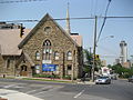 John Street South
 -
 John Street South
 -
 Sir John A. Macdonald, statue, Gore Park
 -
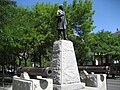 Sir John A. Macdonald, statue, Gore Park


References
- ^ Bailey, Thomas Melville (1981). Dictionary of Hamilton Biography (Vol I, 1791-1875). W.L. Griffin Ltd. p. 143.
- ^ "City Hall town meetings at local Taverns- 1833". Archived from the original on September 26, 2007. Retrieved 2007-03-26.
- ^ Houghton, Margaret (2002). Hamilton Street Names: An Illustrated Guide. James Lorimer & Co. Ltd.
- ^ "Sir John A. Macdonald statue, 1893". Archived from the original on September 26, 2007. Retrieved 2007-03-26.
- ISBN 1-55028-804-0.
- ^ "The Hamilton Memory Project;" (Press release). The Hamilton Spectator- Souvenir Edition page MP43. June 10, 2006.
- ^ "Statue info. at myhamilton.ca". Archived from the original on 2007-09-26. Retrieved 2007-03-20.
- ^ Statue info. at myhamilton.ca
- ^ "Hamilton Neighbourhood Boundaries, (map.hamilton.ca)" (PDF). Archived from the original (PDF) on 2007-09-27. Retrieved 2007-05-11.
- MapArt Golden Horseshoe Atlas - Page 647 - Grids E12, F12, G12, H12
External links
- Beasley Neighbourhood (ourbeasley.com)
- Downtown Hamilton
- North End Neighbours
- Niagara Escarpment Commission (NEC) Official web site
- Google Maps: John Street (Hybrid)