
Valencian Community
Valencian Community
Comunitat Valenciana ( Autonomous community | |
|---|---|
|
Parliament of Spain | |
| Congress seats | 32 of 350 (9.1%) |
| Senate seats | 17 of 265 (6.4%) |
| Area | |
| • Total | 23,255.43 km2 (8,978.97 sq mi) |
| • Rank | |
| Official languages | |
11th) | |
| Time zone | CET (UTC+1) |
| • Summer (DST) | CEST (UTC+2) |
| Postal code prefixes | |
| ISO 3166 code | ES-VC |
| Telephone code(s) | +34 96 |
| Currency | Euro (€) |
| Official holiday | October 9 |
| Patron saint(s) | Saint Vincent |
| Website | gva |
 | |
The Valencian Community[a] is an autonomous community of Spain. It is the fourth most populous Spanish autonomous community after Andalusia, Catalonia and the Community of Madrid with more than five million inhabitants.[3][4] Its homonymous capital Valencia is the third largest city and metropolitan area in Spain. It is located along the Mediterranean coast on the east side of the Iberian Peninsula. It borders Catalonia to the north, Aragon and Castilla–La Mancha to the west, and Murcia to the south, and the Balearic Islands are to its east. The Valencian Community is divided into three provinces: Castellón, Valencia and Alicante.
According to Valencia's
Official languages are Spanish and
Etymology
The city of Valencia (capital of the region) was founded by the
With the establishment of the Muslim Taifa of Valencia, during the Al-Andalus period, the name developed to بلنسية (Balansiyya). The modern names of the city areValencia (Spanish) and València (Valencian). The older spellings Valençia, Ualençia and Ualència are also found in pre-reform Spanish and Valencian texts.
To distinguish it from its capital city, a number of names have been used for the region. After the Christian conquest, it became the kingdom of Valencia. In the last decades, Valencian community has become the preferred name to avoid any controversy.
Naming controversy
"Valencian Community" is the standard translation of the official name in Valencian recognized by the Statute of Autonomy of 1982 (Comunitat Valenciana).[5] This is the name most used in public administration, tourism, the media and Spanish written language. However, the variant of "Valencian Country" (País Valencià) that emphasizes the nationality status of the Valencian people is still the preferred one by left-wing parties, civil associations, Valencian written language and major Valencian public institutions.[12][13][14]
"Valencian Community" is a
The autonomous community can be homonymously identified with its capital "Valencia".[15] However, this could be disregarding of the provinces of Alicante and Castellón. Other more anecdotal translations have included "Land of Valencia",[16] "Region of Valencia"[17] and "Valencian Region".[18] The term "Region", however, carries negative connotations among many Valencians because it could deny their nationality status.
History

The pre-Roman autochthonous people of the Valencian Community were the Iberians, who were divided in several groups (the Contestani, the Edetani, the Ilercavones and the Bastetani).
The Greeks established
The Romans founded the city of .
However, the origins of present-day Valencia date back to the Kingdom of Valencia, which came into existence in the 13th century. James I of Aragon led the Christian conquest and colonization of the existing Islamic taifas with Aragonese and Catalan colonizers in 1208; they founded the Kingdom of Valencia as a third independent country within the Crown of Aragon in 1238.
The kingdom developed intensively in the 14th and 15th centuries, which are considered the Golden Age of the Valencian culture,[19] with significant works like the chivalric romance of Tirant lo Blanch. Valencia developed into an important kingdom in Europe economically through the silk trade. It also rose to power politically with the rise of the Crown of Aragon, (within which the Kingdom of Valencia had achieved the largest population and the greatest economic power at that time)[20] and the ascension of the Valencian House of Borja in Rome (see Route of the Borjas, Route of the Monasteries and Route of the Classics).
After a slow decline following the
In 1707, in the context of the War of the Spanish Succession, and by means of the Nova Planta decrees, king Philip V of Spain abolished the Kingdom of Valencia, and the rest of the states belonging to the former Crown of Aragon and which had retained some autonomy, and subordinated it to the structure of the Kingdom of Castile and its laws and customs. As a result of this, the institutions and laws created by the Law of Valencia (Furs de València) were abolished and the usage of the Valencian language in official instances and education was forbidden. Consequently, with the House of Bourbon, a new Kingdom of Spain was formed implementing a more centralized government and absolutist regime than the former Habsburg Spain
The first attempt to gain
The Valencian Statute of Autonomy make clear that Valencia is intended to be the modern conception of self-government of the Valencian Community from the first autonomist movements during Second Spanish Republic, but also joining it to the traditional conception of Valencian identity, as being the successor to the historical Kingdom of Valencia.[6] In fact, after a bipartisan reform of the Valencian Statute of Autonomy in 2006, it records the foral civil law, using the traditional conception of a kingdom, and, on the other hand, it also recognizes Valencia as a nationality, in accordance with the modern conception.
Geography

Relief
The inland part of the territory is craggy, with some of the highest peaks in the Valencia and Castellón provinces forming part of the Iberian Mountain Range. The mountains in the Province of Alicante are in turn a part of the Subbaetic Range.
The most emblematic mountain of the Valencian Community is the
The rather thin coastal strip is a very
There are many important
In addition to mainland Valencia, the Valencian territory administers the tiny Columbretes Islands and the coastal inhabited islet of Tabarca.
Climate

Valencia has a generally pleasant climate, with mild winters and hot summers, heavily influenced by the neighbouring Mediterranean sea. Still, there are important differences between areas:
- Typical micro climate in the Marina Alta and the Safor comarques just north of Cap de la Nau cape, which accumulates an average of up to 1000 mm. due to an orographic liftphenomenon.
- highland climate (Köppen Csb). These are the innermost lands and those at a higher elevation (cities included here are, amongst others, Alcoy, Morella, Requena and Villena). Here winters are cool to cold, especially at night (a few days of snow are not unusual), summers mild to hot and rainfall more evenly distributed through the year. The lower registered temperatures in the Valencian Community were in these inland areas during the cold wave of 1956. Temperatures plunged to nearly −20 °C; as in Vistabella del Maestrat (−19 °C) and Castellfort (–17 °C).[24]
- Villajoyosa through the southernmost border of the territory (cities included here are, amongst others, Alicante, Benidorm, Elche, Orihuela and Torrevieja). Summers are hot and dry, winters are mild and its most prominent feature is a very scarce precipitation, typically below 300 mm. per year which is most likely to happen during spring and autumn. The reason for this lack of precipitation is the marked rain shadow effect caused by hills to the west of the Alicante province (and, to a lesser degree, those in the northern part of the province which, in turn, enhance the inverse orographic lift effect around Cap de la Nau).
The
Hydrography
There are only two major rivers: the
-
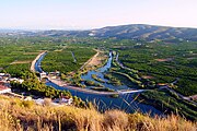
-

-
 Bridge over theXúquer river

.jpg)
.jpg)
Demographics
| Year | Pop. | ±% |
|---|---|---|
| 1900 | 1,587,533 | — |
| 1910 | 1,704,127 | +7.3% |
| 1920 | 1,745,514 | +2.4% |
| 1930 | 1,896,738 | +8.7% |
| 1940 | 2,176,670 | +14.8% |
| 1950 | 2,307,068 | +6.0% |
| 1960 | 2,480,879 | +7.5% |
| 1970 | 3,073,255 | +23.9% |
| 1981 | 3,646,870 | +18.7% |
| 1991 | 3,857,234 | +5.8% |
| 2001 | 4,162,776 | +7.9% |
| 2011 | 5,009,931 | +20.4% |
| 2021 | 5,067,911 | +1.2% |
| Source: INE | ||
Urbanization
The estimate population according to the
| Rank | Comarca
|
Municipal pop. | Rank | Comarca
|
Municipal pop. | ||||
|---|---|---|---|---|---|---|---|---|---|
 Valencia  Alicante |
1 | Valencia | Valencia | 800,215 | 11 | Sagunto | Camp de Morvedre | 67,173 |  Elche  Castellón de la Plana |
| 2 | Alicante | Alacantí | 337,482 | 12 | Alcoy |
Alcoià | 59,354 | ||
| 3 | Elche | Baix Vinalopó | 234,765 | 13 | San Vicente del Raspeig |
Alacantí | 58,978 | ||
| 4 | Castellón de la Plana | Plana Alta | 174,264 | 14 | Elda | Vinalopó Mitjà | 52,813 | ||
| 5 | Torrevieja | Vega Baja del Segura | 84,667 | 15 | Vila-real |
Plana Baixa | 51,239 | ||
| 6 | Torrent | Horta Oest | 83,962 | 16 | Alzira | Ribera Alta | 44,938 | ||
| 7 | Orihuela | Vega Baja del Segura | 78,505 | 17 | Mislata | Horta Oest | 44,320 | ||
| 8 | Gandia | Safor | 75,798 | 18 | Dénia | Marina Alta | 42,827 | ||
| 9 | Paterna | Horta Oest | 71,035 | 19 | Burjassot | Horta Nord |
38,632 | ||
| 10 | Benidorm | Marina Baixa | 70,450 | 20 | Ontinyent | Vall d'Albaida | 35,761 | ||
Valencian population traditionally concentrated in localities with
.png)
Important historical cities include Sagunt and Dénia in Roman times; Valencia, Alicante, Xàtiva, Orihuela, Elche, Gandia, and Vila-real later on in history and, more recently, Alzira and Castellón de la Plana. Another set of noncoastal cities increased significantly in numbers due to industrialization in the 20th century, including Alcoy, Elda, Ontinyent, Petrer, Villena, and La Vall d'Uixó
Metropolitan areas
In more recent years, concentration in provincial capitals and its metropolitan areas has augmented considerably (e.g.
| Rank | Metropolitan Area | Province | Population |
|---|---|---|---|
| 1 | Valencia | Valencia |
1,705,742 |
| 2 | Alicante–Elche | Alicante |
785,020 |
| 3 | Castellón de la Plana | Castellón | 386,906 |
| 4 | Alzira–Xàtiva | Valencia |
348,582 |
| 5 | Benidorm–Villajoyosa | Alicante |
183,253 |
Government
Institutions of government: La Generalitat

In the process whereby democracy was restored in Spain between 1975 and 1978, the
All autonomous communities were organized politically within a
A new Statute of Autonomy was promulgated in 2006. The government of Valencia is represented by the Generalitat Valenciana (statutorily referred to simply as La Generalitat) constituted by three institutions:[26]
- the Corts Valencianes (Valencian parliament), the legislature, which is to be integrated by a minimum of ninety-two representatives (diputats) elected through universal suffrage by proportional representation for a four-year period;
- the President of the Generalitat Valenciana must obtain the vote of confidence from the Courts; the current President is Ximo Puig (from the Socialist Party of the Valencian Country). The Vice President is Mónica Oltra (from Compromís, a Valencianistparty).
- the Council of the Generalitat Valenciana (Valencian government), a collegiate institution with executive powers, integrated by the President him/herself and the cabinet members appointed by him/her.
The Generalitat can also be integrated by the institutions that the Valencian Courts create. The Courts have approved the creation of the Síndic de Greuges (Ombudsman), the Sindicatura de Comptes (Public Audit Office), the Consell Valencià de Cultura (Valencian Council of Culture), the Acadèmia Valenciana de la Llengua (Valencian Academy of the Language), the Consell Jurídic Consultiu (Juridic and Consultative Council) and the Comité Econòmic i Social (Social and Economic Committee).
The current government is formed by a left coalition between the Socialist Party of the Valencian Country and Compromís, with also the support of Podemos.
Administrative divisions
Prior to the 1833 territorial division of Spain Valencia was divided into four administrative provinces of Spain: Alicante, Castellón, Valencia and Xàtiva.
From 1833, the current three-province system was consolidated:
The Valencian Community is further divided into 34
Economy

.jpg)
Valencia is long and narrow, running mainly north–south; historically, its rather steep and irregular terrain has made communications and the exploitation of the soil difficult, although the soil of the coastal plain is particularly
The Valencian territory has few natural resources; the only important mineral deposit is the marble quarried in Alicante province.
Hydrological resources (see Geography above) are also lacking: the demand for water exceeds the supply, with this imbalance especially serious in Alicante province. In particularly severe drought years, the problem is managed through occasional nocturnal restrictions during summer and exploitation of aquifers. Valencia's water needs result in harsh contention with neighbouring regions such as Castilla–La Mancha and Catalonia.
Agriculture—more specifically,
Though the low insulation rate and overall stable weather during the summer may pose a threat to water supplies for agriculture and human consumption, conversely this climate allows tourism to be the province's main industry. Very dense residential housing along the coast, occupied by locals, people from inland Spain and from other EU countries (mostly from the British Isles, Benelux, Germany and Scandinavia), boosts the summertime population (and hydrological demands).
In 2004, Valencia's GDP was 93.9% of the European Union average,
In 2008, the Valencia Country generated 9.7% of the Spanish GDP. In L[vague] of human resources, the unemployment rate was over 21% in 2009, and even greater among women,[28] and the rate of activity reached 56.8% in 2002. The typical Valencian business is a small-to-medium-sized company, mainly family-owned and operated, although there are some multinationals.
In addition to tourism, the Valencian Community has significant exports, and it ranks second in this respect among the Spanish autonomous communities, constituting 12% of the national total. Major exports include agricultural products, ceramic tiles, marble products and cars (Ford has an assembly line in Almussafes), which make the port of Valencia one of the busiest in Europe.
Unemployment
The unemployment rate stood at 15.6% in 2018 and was higher than the national average.[29]
| Year | 2006 | 2007 | 2008 | 2009 | 2010 | 2011 | 2012 | 2013 | 2014 | 2015 | 2016 | 2017 | 2018 |
|---|---|---|---|---|---|---|---|---|---|---|---|---|---|
| unemployment rate (in %) |
8.3 | 8.7 | 12.0 | 20.8 | 22.9 | 24.0 | 27.2 | 28.0 | 25.8 | 22.8 | 20.6 | 18.2 | 15.6 |
Language
Valencian is the name Valencians use to refer to the Catalan language.[30] In the Late Middle Ages, due to Valencia becoming its own kingdom, Valencians popularized the term Valencian over the term Catalan.[31]
Valencian was marginalized during Franco's dictatorship (1939–1975) in favor of
Modern Valencian shares similar
Valencian Sign Language is widely used by Valencian deaf persons and is also granted protection under the Statute.
The
Areas of linguistic predominance

Not all of the Valencian territory is historically Valencian-speaking; about 500,000 people, or 10% of the population, live in inland areas that are traditionally Spanish-speaking. These regions include the areas where
Knowledge
| Knowledge of Valencian | ||||
|---|---|---|---|---|
| 1986 | 1991 | 2001 | 2011 | |
| Can understand | 77.12% | 83.24% | 86.36% | 84.78% |
| Can speak | 49.49% | 51.09% | 48.88% | 51.18% |
| Can read | 24.36% | 37.98% | 47.24% | 58.35% |
| Can write | 7.03% | 15.17% | 24.07% | 31.77% |
| Source: Conselleria d'Educació, Cultura i Esport(2010) Cens 2011. Dades generals coneixement[38] | ||||
Most of the population have at least a passive knowledge of Valencian, which allows normal communication in this language across the Valencian Community. Thanks to its implementation in public administration and the education system in recent decades, knowledge of Valencian has increased phenomenally both in absolute and relative terms, most significantly in the case of its written standard. The source also reveals that knowledge varies greatly within the territory, with knowledge in the Province of Alicante being consistently lower than in Castellón and Valencia.
Social use
| Languages spoken at home | ||
|---|---|---|
| Use | Valencian | Spanish |
| Always | 28.8% | 56.2% |
| More often | 3% | 2.6% |
| Alternatively | 5.6% | |
| Other languages | 3.8% | |
| Source: Conselleria d'Educació, Cultura i Esport (2010) Knowledge and social use of Valencian[39] | ||
Despite the increase in knowledge of Valencian, its social use in relative terms is declining, with only a third of the population using it at home according to the Generalitat in 2010. The data collected varies greatly within the Valencian Community, with the percentage of use being over 50% in the regions of Alcoy–Gandia and Júcar–Turia, approximately 40% in Castellón and about 15% in Alicante and the Valencia metropolitan area.
Valencian language controversy
In spite of these arguments, a significant proportion of the Valencian population refuse to identify Valencian with Catalan.
Transports
Air
.PNG)
The Valencian Community is served by three international airports:
A new terminal at Alicante Airport was opened in March 2011. The New Alicante Terminal (NAT) replaced the other two existing terminals T1 and T2, doubling the passenger capacity of the airport to 20m passengers per annum. Valencia airport is also being expanded to serve the higher passenger demand due to new flight connections to the city.
Train

The Valencian Community has an extensive rail system which connects the principal cities with the rest of Spain such as the
In December 2010 the
High-speed rail Madrid–Alicante opened in 2013.
There are some medium-range plans for further high-speed connections, like the Valencia–Bilbao link via Zaragoza or the Mediterranean high-speed rail corridor.
In addition, the Generalitat Valenciana has planned on building a regional high-speed rail along the coast to connect all major coastal cities like Valencia, Gandia, Dénia, Benidorm, Villajoyosa, Alicante and Torrevieja.
Commuter rail and Metro

While the Valencian-owned company,
Ports

By sea, the Valencian Community is served by several ferry routes and cargo ports, and in the major cities, Valencia and Alicante, cruise ships dock on a regular basis.
In point 20 of article 149 of the
Public services
Education
State Education in Spain and the Valencian Community is free and compulsory from six to sixteen years of age. The current education system is called LOE (in reference to the Llei Orgànica d'Educació).[42]
- From three to six years: Preparatory School (Infantil, popularly known as Preescolar)
- From six to twelve years: Primary School (Primaria)
- From twelve to sixteen years: Compulsory Secondary School (Secundaria)
- From sixteen to eighteen years: Post-Secondary School (Bachillerato)
Children from three to five years old in the Valencian Community have the option of attending the infantil or pre-school stage, which is non-compulsory and free for all students. It is regarded as an integral part of the education system with infantil classes in almost every primary school. There are some separate nursery schools.
Valencian students aged six to sixteen undergo primary and secondary school education, which are compulsory and free of charge. Successful students are awarded a Secondary Education Certificate, which is necessary for entering further (optional) education as for their University or Vocational Studies. Once students have finished their Batxillerat (Spanish: Bachillerato), they can take the PAU exams (Proves d'Accés a la Universitat), commonly known as Selectiu.
The secondary stage of education is normally referred to by their initials, e.g. ESO standing for Educació Secundària Obligatòria.
The Valencian Community is home to a number of prestigious universities like the
Nowadays the
Other universities are
Media

Until its dissolution in November 2013, the public-service Ràdio Televisió Valenciana (RTVV) was the main broadcaster of radio and television in the Valencian Community. The Generalitat Valenciana constituted it in 1984 in order to guarantee the
Prior to its dissolution, the administration of RTVV under the People's Party (PP) had been controversial due to accusations of ideological manipulation and lack of plurality. The news broadcast was accused of giving marginal coverage of the Valencia Metro derailment in 2006 and the indictment of President de la Generalitat Francisco Camps in the Gürtel scandal in 2009.[44] Supervisors appointed by the PP were accused of sexual harassment.[45]
In face of an increasing debt and shrinking audiences that had fallen under 10 and even 5% of share in recent years, RTVV announced in 2012 a plan to shed 70% of its labour. The plan was nullified on 5 November 2013 by the
Having lost all revenues from advertisements and facing high costs from the termination of hundreds of contracts, critics question whether the closure of RTVV has improved the financial situation of the Generalitat, and point out to plans to benefit private-owned media.[48] Currently, the availability of media in the Valencian language is extremely limited. All the other autonomous communities in Spain, including the monolingual ones, have public-service broadcasters, with the Valencian Community being the only exception despite being the fourth most populated.
In 2016 the renewed Valencian government announced that a new public media corporation was to be created. The Valencian Media Corporation was founded in July 2016, as it started the creation of a new TV channel and radio station, by the name of À Punt (ɑ̀). In June 2018 the new public TV channel was launched by Valencian Media Corporation, the newly formed agency of the Generalitat Valenciana.
Culture
Gastronomy

The Valencian gastronomy is of great variety, although their more international dishes are rice-based (arròs in Valencian), like the Valencian paella known worldwide. Rice is a basic ingredient in many of the typical dishes, like the arròs a banda, arròs al forn, arròs amb costra, arròs caldós, arròs del senyoret, arròs negre, among many.
Pasta dishes include the fideuà. Its main ingredients are pasta noodles, fish and shellfish.
The Valencian Mediterranean climate favors the cultivation of vegetables and citrus fruits, with the cultivation of the orange (Valencian: taronja) being perhaps of highest importance as one of the typical fruits of Valencian agriculture.
The great majority of
Valencian symbols

The official Valencian anthem is the Hymn of the Regional Exhibition of 1909 (Himne de l'Exposició Regional de 1909 in Valencian; commonly known as the Himne de València, "Anthem of Valencia"), in whose composition the old hymn of the City of Valencia of the 16th century is included. The emblem of the Valencian Generalitat (coat of arms) includes the heraldry of King Peter IV of Aragon, representative of the historical Kingdom of Valencia, whose shield is inclined towards the right, or, four bars Gules.
The official flag, the
Other symbols are used at different levels by the Valencian society, like the heraldic animals of rat-penat (a bat) and drac alat (a winged dragon which was the emblem of James I).
One of the most recognized and representative Valencian symbols are the music and dance of the
Celebrations
- Falles of Valencia– from the 15th to the 19th of March
- Fogueres de Sant Joan of Alicante– from the 19th to the 24th of June
- Misteri of Elche – 14th and 15 August
- Muixeranga: Algemesí – 7th and 8 September
- Moros i Cristians: Alcoy – from the 22 to 24 April
- Tomatina of Buñol– last Wednesday in August
- Magdalena of Castellón – 3rd Saturday of Lent
Valencian Community Day
- October 9: Official day of the Valencian Community and public holiday in the entire region. This day commemorates the entrance of James I to the city of Valencia on the year 1238.
Sports

.jpg)
The
Association football is the most widely known and played sport. There are teams in every town or village, two of which are currently playing in La Liga, Spanish top professional division: Valencia CF (widely considered one of the most successful clubs in Spanish football history, having won six La Liga titles and 8 Copa del Rey) and Villarreal CF. There are two clubs playing in the Segunda División, Levante UD and Elche CF. Other historical teams that have been in La Liga in the past are CD Alcoyano, Hércules CF and CD Castellón.
Professional basketball is represented currently in Liga ACB, the top professional division, by Valencia Basket, who won its first league title in 2017. Two more teams, CB Lucentum Alicante and AB Castelló are present in the second division.
Regarding female professional sports, the historical
Another relevant game is the
Petanca and its variant Calitx are traditional sports as well, especially in towns or among elders.
Image gallery
-

-

-
 Alicante
 -

-

-

-

-
 Rock of Ifac inCalp
 -

-
 Altamira Palace, Elche
 -
 Elche palm grove
 -

-

-

-

-

-

-
 Peñíscola
 -

-
 Sagunt
 -
 Sueca
Sueca -
-

-
 Orihuela, Vega Baja del Segura comarca
 -

-

-

-
 Valencian espardenya
 -
 Valencian women with traditional dress and hair
 -
 A historical Valencian men costume the Xaraguell
 -
 Tabaleter with typical Valencian drums


.jpg)

.jpg)


See also
Notes
- ^ Pronounced /vəˈlɛnsiən ... , -ʃən ... / və-LEN-see-ən ..., -shən ...; Valencian: Comunitat Valenciana, pronounced [komuniˈtad valensiˈana]; Spanish: Comunidad Valenciana, pronounced [komuniˈðað βalenˈθjana].
- ^ The Valencian Normative Dictionary of the Valencian Academy of the Language states that Valencian is a "romance language spoken in the Valencian Community, as well as in Catalonia, the Balearic Islands, the French department of the Pyrénées-Orientales, the Principality of Andorra, the eastern flank of Aragon and the Sardinian town of Alghero (unique in Italy), where it receives the name of 'Catalan'."
References
- ^ "Contabilidad Regional de España" (PDF). www.ine.es.
- ^ "Sub-national HDI – Area Database – Global Data Lab". hdi.globaldatalab.org. Retrieved 24 June 2023.
- ^ a b "Población de España en 2021, por comunidad autónoma". Statista. July 2021. Retrieved 7 November 2021.
- ^ Instituto Nacional de Estadística, Madrid, 2020.
- ^ a b "Estatut d'Autonomia". Corts Valencianes. 1982. Archived from the original on 3 October 2018. Retrieved 9 April 2015.
- ^ a b c Preamble on Valencian Statutes of Autonomy 1982 and 2006: "Aprovada la Constitució Espanyola, va ser, en el seu marc, on la tradició valenciana provinent de l'històric Regne de València es va trobar amb la concepció moderna del País Valencià i va donar origen a l'autonomia valenciana [...]" - Preamble of Valencian Statute of Autonomy (reformed in 2006) Archived 2007-09-26 at the Wayback Machine
- Real Academia Española. Retrieved 9 June 2017.
- ^ "Dictamen sobre los Principios y Criterios para la Defensa de la Denominación y entidad del Valenciano" (PDF).
It is a fact the in Spain there are two equally legal names for referring to this language: Valencian, as stated by the Statute of Autonomy of the Valencian Community, and Catalan, as recognised in the Statutes of Catalonia and Balearic Islands.
- ^ Decreto 84/2008, de 6 de junio, del Consell, por el que se ejecuta la sentencia de 20 de junio de 2005, de la Sala de lo Contencioso-Administrativo del Tribunal Superior de Justicia de la Comunitat Valenciana.
- ^ "no trobat". sindicat.net.
- S2CID 143313778.
- ^ Mollà, Toni (1998). "A Catalans language and linguistic community in the Valencian Country" Diàlegs: revista d'estudis polítics i socials Vol. 1, Nº. 2, 1998, pags. 33-45
- València 1699, impremta de Vicente Cabrera. Biblioteca Nacional de España, Signatura: 3/64918 Archived 2007-09-27 at the Wayback Machine. Reproducció: DGmicro/21722.
- ^ Socialist Party of the Valencian Country (Partit Socialista del País Valencià, PSPV)
- ^ According to article Valencia from Britannica Online Encyclopedia
- ^ Scenery in Land of Valencia Archived 9 May 2008 at the Wayback Machine, edited by the Valencian Agency of Tourism
- ^ Terms mainly used from the Department of Tourism of the Valencian Government. See official publications[dead link], and an example Archived 12 May 2008 at the Wayback Machine of using "Region of Valencia". The other term, "Land of Valencia" is also used by this department
- ^ CVNews, English-language magazine published by the Valencia Region Tourist Board
- ^ Siglo de Oro Valenciano (Spanish Wikipedia)
- ^ José Escribano Úbeda-Portugués: España y Europa a través de la Historia. Desde el siglo XV al Siglo XVIII pp 16-17
- ^ Proyecto de Estatuto de Autonomía para el País Valenciano (1937) (Spanish Wikipedia)
- ^ Real Decreto-Ley 10/1978, de 17 de marzo, por el que se aprueba el Régimen Preautonómico del País Valenciano (Spanish Wikipedia)
- ^ Caballer, Neus (7 October 2011). "Fallece el expresidente preautonómico de la Generalitat Enrique Monsonís" [Former pre-autonomous president of the Generalitat Enrique Monsonís dies]. El País (in Spanish).
- ^ José Ángel Núñez; Carlos Muedra; Vicente Aupí. "La gran ola de frío de febrero de 1956 en la España mediterránea" [The great cold snap of February 1956 in Mediterranean Spain] (PDF) (in Spanish).
- AEMET. Retrieved 4 February 2022.
- ^ "Third Section, First Chapter of the Statute of Autonomy of the Valencian Community" (in Spanish). Archived from the original on 26 December 2007. Retrieved 14 December 2007.
- ^ "Regional GDP per inhabitant in the EU27: GDP per inhabitant in 2004 ranged from 24% of the EU27 average in Nord-Est in Romania to 303% in Inner London" (PDF), Eurostat News Release, Eurostat Press Office, 19 February 2007, archived from the original (PDF) on 26 March 2009, retrieved 17 November 2012
- ^ "El paro alcanza el 23% en la Comunidad Valenciana" [Unemployment reaches 23% in the Valencian Community]. Valencia Plaza (in Spanish). EFE.
- ^ "Regional Unemployment by NUTS2 Region". Eurostat. European Union.
- ^ "AVL". Diccionari normatiu valencià. Archived from the original on 30 September 2018. Retrieved 9 March 2011.
- ^ Beltran i Calvo & Segura i Llopes 2018, p. 35.
- ^ The implementation of Franco's regime in the Valencian Community since 1939 meant the Valencian ban on its use on the radio, books, theater, different civilians forms such as wedding invitations, signs and announcements, person's first names, cinema (until 1964), in all public and private schools, on the gravestones of the cemeteries and mortuary skeletons, in the nomenclature of hotels, restaurants or brands, on inscriptions in the Civil register, on the names of the streets, among other fields.
Mayans Balcells, Pere (2019). Cròniques negres del català a l'escola. Edicions de 1979. ISBN 9788494720147.
- ^
Solé i Sabaté, Josep M.; Villaroya, Joan (1994). Cronologia de la repressió de la llengua i la cultura catalanes 1936-1975. Barcelona: Curial. ISBN 8472569578.
- ^
Ferrer i Gironés, Francesc (1985). La persecució política de la llengua catalana. Barcelona: Edicions 62. ISBN 8429723633.
- ^ Ministerio de la Gobernación (Gazeta of 17 May 1940) (CCITT T.& G4 Facsimile TIFF). Order of 16 May 1940 forbidding the use of generic foreign terms in lettering, samples, advertisements, etc.
- ^ "La població que sap escriure en català es quintuplica en els últims 25 anys". Conselleria d'Educació, Cultura i Esport. November 2014. Archived from the original on 23 September 2015. Retrieved 9 April 2015.
- ^ "Knowledge and social use of Valencian language. General survey 2015. Synthesis of results". Conselleria d'Educació i Cultura, Generalitat Valenciana. Valencian government (Generalitat Valenciana). 2015. Retrieved 3 April 2020.
- ^ "Cens 2011. Dades generals coneixement" [Census 2011. General information]. Conselleria d'Educació, Cultura i Esport (in Valencian). 2011. Archived from the original on 14 April 2015. Retrieved 9 April 2015.
- ^ "Coneixement i ús social del valencià" [Knowledge and Social Use of Valencian]. Conselleria d'Educació, Cultura i Esport. 2010. Archived from the original on 23 September 2015. Retrieved 9 April 2015.
- ^ Ortega, Lorena (15 September 2015). "First commercial flight lands at Castellón's former 'ghost' airport". El País.
- ^ "Conozca GTP". p. 17. Archived from the original on 12 December 2013. Retrieved 12 December 2013.
- ^ "Sistema Educativo LOE" [LOE Educational System]. Spanish Ministry of Education (in Spanish). Archived from the original on 11 March 2007.
- ^ "Ley de Creación de la Entidad Pública Radiotelevisión Valenciana (RTVV)" [Law on the Creation of the Public Entity Radiotelevisión Valenciana (RTVV)] (PDF) (in Spanish). 1984. Archived from the original (PDF) on 5 December 2013. Retrieved 9 April 2015 – via UGT RTTV.
- ^ "Los escándalos de Canal 9" [The Channel 9 scandals]. VerteleTV (in Spanish). 7 November 2013. Retrieved 9 April 2015.
- ^ "Sanz, destituït de secretari general de RTVV per assetjament sexual" [Sanz, dismissed as RTVV's secretary general for sexual harassment]. Vilaweb (in Catalan). 28 May 2010. Retrieved 9 April 2015.
- ^ Bono, Ferran (7 November 2013). "El fracaso de Fabra acaba con el PP" [Fabra's failure ends with RTVV]. El País (in Spanish). Retrieved 9 April 2015.
- ^ "Police evict TV staff in Spain after closure of station". BBC News. 29 November 2013. Retrieved 9 April 2015.
- ^ "El coste del cierre de RTVV asciende a 144,1 millones". Levante-EMV. 2014. Retrieved 9 April 2015.
- ^ See logo of one of major trade unions: CCOO-PV
- ^ See usage of the Senyera by a Valencian cultural association: ACPV Archived 5 July 2007 at the Wayback Machine
- Bloc Nacionalista Valencià, Green Parties, amongst others, whose combined participation in the Autonomous Elections of 2007 achieved 9% of the total votes.
Bibliography
- El llarg camí cap a l'Autonomia Valenciana, de Vicente Ruiz Monrabal. Revista Valenciana d'Estudis autonòmics, núm. 41/42, 3er trimestre de 2003 - 4o trimestre de 2003, p. 372-421. URL: Número 41/42.
- El valencianisme polític, 1874-1936, Alfons Cucó i Giner. 1999, Catarroja, Ed. Afers SL. ISBN 84-86574-73-0.
- Història del País Valencià, Vicente Boix. 1981. Editorial Planeta, ISBN 84-390-0148-7.
- Història del País Valencià, Antoni Furió i Diego. 2001. Edicions 3i4. ISBN 84-7502-631-1.
External links
| ||||||||||||||||||||||||||||||||
