
's-Gravendeel
's-Gravendeel | ||
|---|---|---|
Village | ||
Postal code 3295[1] | ||
| Dialing code | 0186 | |
's-Gravendeel (Dutch pronunciation: [ˌs xraːvə(n)ˈdeːl] ⓘ) is a town and former municipality in the western Netherlands, in the province of South Holland. 's-Gravendeel is on the eastern side of Hoeksche Waard Island on the river Dordtsche Kil. It is connected to Dordrecht by means of the Kil Tunnel.
The village was first mentioned in 1645 as Schravendeel, and means "settlement of the Count (of Holland)".
The Dutch Reformed church is a cruciform church built in 1905 after the 1637 church had burnt down. The tower was destroyed in 1945 and rebuilt in 1951.[5]
's-Gravendeel was home to 928 people in 1840.[4] It was affected by the North Sea flood of 1953. In 1970, the old harbour was filled up and a new harbour was built on the Dordtsche Kil.[5]
The municipality of 's-Gravendeel was merged with Binnenmaas on 1 January 2007. Since 1 January 2019, it is part of the new municipality Hoeksche Waard.[6]
Gallery
-
 Windmill: korenmolen het Vliegend Hert
 -
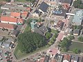 Reformed church in 's-Gravendeel with its notable church moat


References
- ^ a b c "Kerncijfers wijken en buurten 2021". Central Bureau of Statistics. Retrieved 4 May 2022.
- ^ "Postcodetool for 3295AA". Actueel Hoogtebestand Nederland (in Dutch). Het Waterschapshuis. 24 July 2019. Retrieved 4 May 2022.
- ^ a b "'s-Gravendeel - (geografische naam)". Etymologiebank (in Dutch). Retrieved 4 May 2022.
- ^ a b "'s-Gravendeel". Plaatsengids (in Dutch). Retrieved 4 May 2022.
- ^ ISBN 90-400-9034-3. Retrieved 4 May 2022.
- ^ Wet samenvoeging gemeenten Binnenmaas, Cromstrijen, Korendijk, Oud-Beijerland en Strijen, 11 July 2018, accessed at overheid.nl
| International | |
|---|---|
| National | |
This South Holland location article is a stub. You can help Wikipedia by expanding it. |