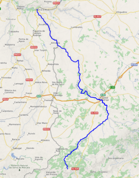
Águeda (river)
| Águeda | |
|---|---|
 The confluence of the Águeda River and Douro as seen from Barca d'Alva | |
 | |
| Location | |
| Country | Portugal, Spain |
| Physical characteristics | |
| Source | Serra das Mesas |
| • location | Spain |
Douro River | |
• coordinates | 41°1′42″N 6°55′52″W / 41.02833°N 6.93111°W |
| Length | 130 km (81 mi) |
| Basin size | 2,537.08 km2 (979.57 sq mi) |
| Discharge | |
| • average | 197.2 m3/s (6,960 cu ft/s) |
| Basin features | |
| Progression | Douro→ Atlantic Ocean |
| River system | Douro |
The Águeda (Portuguese pronunciation: Barca de Alva, Portugal. The Portugal–Spain border follows the Águeda for much of its course.

See also
References
Sources
- Nunes, Ádelia (2010). "Evolução Recente dos Recursos Hídricos Superficiais em 4 Cursos de Água Tributários do Rio Douro" [Recent Evolution in Water Resources in Four Water Tributary Flows of the Douro River] (PDF) (in Portuguese). Lousã, Portugal: Associação Portuguesa de Riscos, Prevenção e Segurança. pp. 29–38. Retrieved 17 November 2010.
