
Åndalsnes
Åndalsnes
Historic: Aandalsnes | |
|---|---|
Rauma Municipality | |
| Established as | |
| Town (By) | 1996 |
| Area | |
| • Total | 2.23 km2 (0.86 sq mi) |
| Elevation | 2 m (7 ft) |
| Population (2017)[1] | |
| • Total | 2,403 |
| • Density | 1,078/km2 (2,790/sq mi) |
| Demonym | Åndalsnesing |
| Time zone | UTC+01:00 (CET) |
| • Summer (DST) | UTC+02:00 (CEST) |
| Post Code | 6300 Åndalsnes |
In 2017 the 2.23-square-kilometre (550-acre) town had a population of 2,403 and a population density of 1,078 inhabitants per square kilometre (2,790/sq mi).[1]
Åndalsnes has an
Geography
Åndalsnes is located at the mouth of the river
The river flows through the
Transportation
The European route E136 highway and Norwegian County Road 64 pass through Åndalsnes. County Road 64 heads to the towns of Molde and Kristiansund to the north and the E136 highway heads to the town of Ålesund to the west and to Dombås to the southeast.
Trains on the Rauma Line terminate at the port of Åndalsnes, with bus connections to the nearby towns of Molde and Ålesund.
History
The village of Åndalsnes was the
During
At the waterfront here, rigs were built to develop off-shore oil and gas wells in the North Sea, with the railroad bringing steel, etc.to the water's edge, and the rigs taken out to sea, past Ålesund, through the fiord waters.
In 1996, the
Media
The newspaper Romsdalsbladet was published in Åndalsnes from 1947 to 1948.[5]
The town's newspaper, Åndalsnes Avis, had a circulation of 4,125 in 2007.[6]
Notable people
Notable people that were born or lived in Åndalsnes include:
- Kitty Lossius, teacher and novelist[7]
Gallery
-
 Åndalsnes
 -
 Winter in Åndalsnes
 -
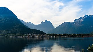
 View of the port area and mouth of the river


See also
References
- ^ a b c Statistisk sentralbyrå (1 January 2018). "Urban settlements. Population and area, by municipality".
- ^ "Åndalsnes, Rauma (Møre og Romsdal)". yr.no. Retrieved 2019-07-02.
- ^ "Offisiell åpning av kai på Åndalsnes 24. mai - Nyheter fra havna - Molde og Romsdal Havn IKS". Molde og Romsdal Havn IKS (in Norwegian Bokmål). Retrieved 2016-11-18.
- ^ Store norske leksikon. "Åndalsnes"(in Norwegian). Retrieved 2013-05-31.
- ^ Moen, Eirik (1988). "Romsdalsbladet og Romsdals reising". Romsdal Sogelag Årsskrift 1988. Molde: Romsdal Sogelag: 48–53.
- ^ "MBL Aviskatalogen - Velg utgave - Velg fylke" (in Norwegian). Aviskatalogen. 2007. Archived from the original on 2008-01-13. Retrieved 2008-04-11.
- Store norske leksikon(in Norwegian). Oslo: Kunnskapsforlaget. 2019. Retrieved January 4, 2021.
Møre og Romsdal county, Norway | |||||||
|---|---|---|---|---|---|---|---|
| |||||||
 | Towns & cities |
| |||||
| Municipalities |
| ||||||
| |||||||
| International | |
|---|---|
| National | |