
Ölper
Braunschweig-Ölper | |
|---|---|
 Ölper Turm | |
 Coat of arms | |
Location of Ölper within Braunschweig.  | |
 Braunschweig-Ölper  Braunschweig-Ölper | |
| Coordinates: 52°17′10″N 10°29′48″E / 52.28611°N 10.49667°E | |
| Country | Germany |
| State | Lower Saxony |
| District | urban district |
| City | Braunschweig |
| Population (2016-12-31) | |
| • Total | 1,411 |
| Time zone | UTC+01:00 (CET) |
| • Summer (DST) | UTC+02:00 (CEST) |
| Postal codes | 38114 |
| Dialling codes | 0531 |
| Vehicle registration | BS |
| Website | Website |
Ölper, formerly a village, is a quarter (Stadtteil) of the city of Braunschweig in Lower Saxony, Germany. It lies to the north of the city centre on the river Oker. It is part of the Stadtbezirk Lehndorf-Watenbüttel.
History
The first mention of the village of Ölper, then called Elbere, is in 1251.
In 1761 during the
The village of Ölper was incorporated into the city of Braunschweig in 1934.[1] Recent developments have included the construction of a motorway junction in 1974–78 and the creation of the Ölpersee, a large lake in former gravel workings. Today, although it is now largely a dormitory suburb, there are still four active farms in Ölper including the only dairy farm within the city boundaries. Amongst local clubs and societies, BSV Ölper 2000 is the local association football team.[2]
Gallery
-
 The original Ölper Tower, which was demolished in 1825.
 -
 The present Ölper Tower.
 -
 A model of Ölper Mill as it appeared in 1800.
 -
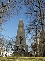 The memorial to the Battle of Ölper (1809).
 -
 The Ölpersee, formerly gravel workings.


References
- ^ a b "Ölper. Ein ehemaliges Pfahl- und Bauerndorf". www.braunschweig.de. City of Braunschweig. Retrieved 31 August 2017.
- ^ a b "Ölper". www.braunschweig.de. City of Braunschweig. Retrieved 20 August 2017.
- ^ Panitzek, M. "Überreste der Ölper Mühle in Braunschweig". www.verstecktes.de. Retrieved 20 August 2017.
- ISBN 978-1848325470.
| International | |
|---|---|
| National | |
This Braunschweig location article is a stub. You can help Wikipedia by expanding it. |