
Ōoka River
cherry trees
located near the river.
Gallery
-
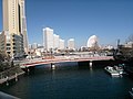 The mouth of the Ōoka River
 -
![Chōjabashi (長者橋 [ja])](//upload.wikimedia.org/wikipedia/commons/thumb/3/3e/Ch%C5%8Djabashi_02.JPG/120px-Ch%C5%8Djabashi_02.JPG) Chōjabashi (長者橋)
Chōjabashi (長者橋) -
 Idogayabashi (井土ヶ谷橋)
 -
![The source of the Ōoka River, in Hitorizawa-Chō (氷取沢町 [ja])](//upload.wikimedia.org/wikipedia/commons/thumb/a/aa/Oooka-River%2CRiverhead.JPG/120px-Oooka-River%2CRiverhead.JPG) The source of the Ōoka River, in Hitorizawa-Chō (氷取沢町)
The source of the Ōoka River, in Hitorizawa-Chō (氷取沢町)
150203.JPG)
![Chōjabashi (長者橋 [ja])](/File:Ch%C5%8Djabashi_02.JPG)
.jpg)
![The source of the Ōoka River, in Hitorizawa-Chō (氷取沢町 [ja])](/File:Oooka-River,Riverhead.JPG)
External links
Wikimedia Commons has media related to Ōoka River.
| |||||||||||||||
| |||||||||||||||
| |||||||||||||||
| |||||||||||||||
| International | |
|---|---|
| National | |
This Kanagawa Prefecture location article is a stub. You can help Wikipedia by expanding it. |
This article related to a river in Japan is a stub. You can help Wikipedia by expanding it. |