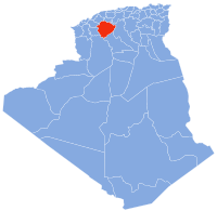
Aïn El Hadid
Aïn El Hadid | |
|---|---|
Commune and town | |
| Coordinates: 8 → 2008] | |
| Country | UTC+1 (CET ) |
Aïn El Hadid is a town and commune in Tiaret Province in northwestern Algeria.
15,482 Population [2008] – Census
441.0 km² Area
35.11/km² Population Density [2008]
1.5% Annual Population Change [1998 → 2008] [2]
References
- ^ "Communes of Algeria". Statoids. Archived from the original on 29 November 2010. Retrieved December 12, 2010.
- ^ "Aïn El Hadid (Commune, Tiaret, Algeria) - Population Statistics, Charts, Map and Location". citypopulation.de. Retrieved 2022-04-03.
35°03′29″N 0°53′0″E / 35.05806°N 0.88333°E

