
Achtkarspelen
Achtkarspelen | |
|---|---|
 Road into Surhuizum | |
|
UTC+2 (CEST) | |
| Postcode | Parts of 9000 range |
| Area code | 0511, 0512 |
| Website | www |
Achtkarspelen (Dutch pronunciation: Friesland in the Northern Netherlands. In 2021, it had a population of 27,900.
History
The name Achtkarspelen, literally meaning "eight
Bishopric of Utrecht
.
The grietenij Achtkarspelen became a
municipality in 1851 as a result of the Municipality Act of Minister of the Interior Johan Rudolph Thorbecke
.
Population centres

The administrative centre in the municipality is Buitenpost.
| Dutch name | West Frisian name | Population |
|---|---|---|
| Augustinusga | Stynsgea | 1332 |
| Boelenslaan | Boelensloane | 1145 |
| Buitenpost | Bûtenpost | 5785 |
| Drogeham | Droegeham | 1751 |
| Gerkesklooster-Stroobos | Gerkeskleaster-Strobos | 1140 |
| Harkema | De Harkema | 4235 |
| Kootstertille | Koatstertille | 2595 |
| Surhuisterveen | Surhústerfean | 5810 |
| Surhuizum | Surhuzem | 1371 |
| Twijzel | Twizel | 1093 |
| Twijzelerheide | Twizelerheide | 1889 |
Notable people
- Derk Holman (1916 in Buitenpost – 1982 in Groningen) a Dutch sculptor and ceramist
- Louw de Graaf (born 1930 in Kootstertille) a retired Dutch politician and trade union leader.
- Gerriet Postma (1932 in Twijzelerheide – 2009) a Dutch painter
- Johannes Lützen Bouma (born 1934 in Twijzelerheide) a Dutch economist and academic
- David Porcelijn (born 1947 in Achtkarspelen) a Dutch composer and conductor
- Joop Atsma (born 1956 in Surhuisterveen) a Dutch politician and sport administrator.
- lo-fisinger and keyboardist
- Oedo Kuipers (born 1989 in Stroobos) a Dutch singer and actor in musical theatre
Gallery
-
 Augustinusga Dwarsreed
 -
 Boelenslaan Oranje gekte
 -
 Begin van de Kolk, Surhuisterveen
 -
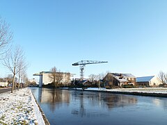 The Hoendiep near Stroobos


.jpg)
References
- ^ "Kerncijfers wijken en buurten 2020" [Key figures for neighbourhoods 2020]. StatLine (in Dutch). CBS. 24 July 2020. Retrieved 19 September 2020.
- ^ "Postcodetool for 9285NH". Actueel Hoogtebestand Nederland (in Dutch). Het Waterschapshuis. Archived from the original on 21 September 2013. Retrieved 6 September 2013.
- ^ "Bevolkingsontwikkeling; regio per maand" [Population growth; regions per month]. CBS Statline (in Dutch). CBS. 1 January 2021. Retrieved 2 January 2022.
External links
Wikimedia Commons has media related to Achtkarspelen.
Places adjacent to Achtkarspelen | ||||||||||||||||
|---|---|---|---|---|---|---|---|---|---|---|---|---|---|---|---|---|
| ||||||||||||||||

 | ||
| ||
| International | |
|---|---|
| National | |
| Geographic | |