
Adelmannsfelden
You can help expand this article with text translated from the corresponding article in German. (February 2009) Click [show] for important translation instructions.
|
Adelmannsfelden | |
|---|---|
|
Flag  Coat of arms | |
Location of Adelmannsfelden within Ostalbkreis district  | |
Ortsteile | |
| Government | |
| • Mayor (2019–27) | Edwin Hahn[1] |
| Area | |
| • Total | 22.90 km2 (8.84 sq mi) |
| Elevation | 471 m (1,545 ft) |
| Population (2022-12-31)[2] | |
| • Total | 1,731 |
| • Density | 76/km2 (200/sq mi) |
| Time zone | UTC+01:00 (CET) |
| • Summer (DST) | UTC+02:00 (CEST) |
| Postal codes | 73486 |
| Dialling codes | 07963 |
| Vehicle registration | AA |
| Website | www.adelmannsfelden.de |
Adelmannsfelden is a municipality in the German state of Baden-Württemberg, in Ostalbkreis district.

Geography
Adelmannsfelden is located in the landscape Ellwangen Hills in the Natural region Swabian-Franconian Forest.[3]
Municipality division
The municipality of Adelmannsfelden includes 18 villages, hamlets, yards and houses.[4] There are four villages: Adelmannsfelden, Bühler, Haid and Stöcken. The three Hamlets are called Mittelwald, Ottenhof and Vorderwald. The yards include Dollishäusle, Eichhorn, Kuderberg, Mäder, Metzelgehren, Ölmühle, Papiermühle, Patrizenhaus and Wendenhof. The houses include Sägmühle and Schleifhäusle. Furthermore, the municipality includes the abandoned yards Altenwinden, Kunhof, Härzern, Limperg, Scheytenmühle, Breitengehren, Finkenhaus, Vorhardsweiler, Herzert, Herrenmühle and Rot diu Mul.
Area division
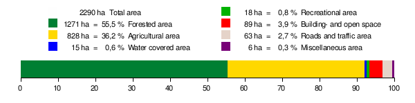
According to data of the
Neighboring municipalities
The municipality borders Rosenberg in the Northeast, Neuler in the East, Abstgmünd in the South, Sulzbach-Laufen in the West and Bühlerzell in the North.
History
The municipality was first mentioned in the Ellwanger annals around 1118. At this time, a castle was built. The castle stood at the place where the Adelmannfelden Castle is located today. Descendants of the Adelmann von Adelmannsfelden family live in Adelmannsfelden Castle until today. The municipality was under changing clerical and secular rule until it became part of the Kingdom of Württemberg in 1806. Specifically, it was under the Oberamt of Aalen, which became the Landkreis Aalen (District of Aalen) during the district reforms in the NS era. Between 1945 and 1952, Adelmannsfelden belonged to the federal state of Württemberg-Baden, which was established in the US occupation zone. In 1952, it became part of the newly established federal state of Baden-Württemberg. The Landkreis Aalen was dissolved during the district reforms in 1973 and Adelmannsfelden now belongs to the district Ostalbkreis.
Notable people

- Franziska von Hohenheim (1748–1811), second wife of Charles Eugene, Duke of Württemberg
Religion
In 1561, the Reformation reached Adelmannsfelden. Since then, the village has been
References
- ^ "Nachrichten Archive". Staatsanzeiger BW (in German). Retrieved 2022-02-10.
- Statistisches Landesamt Baden-Württemberg. June 2023.
- ^ Naturräume Baden-Württembergs. Landesanstalt für Umwelt, Messungen und Naturschutz Baden-Württemberg, Stuttgart 2009
- ISBN 3-17-005708-1, pp. 706–708.
- ^ Fläche seit 1988 nach tatsächlicher Nutzung für Adelmannsfelden. Statistisches Landesamt.
External links
 Media related to Adelmannsfelden at Wikimedia Commons
| International | |
|---|---|
| National | |
| Geographic | |
This Ostalbkreis location article is a stub. You can help Wikipedia by expanding it. |