Ahoada West
Appearance
Ahoada West | |
|---|---|
UTC+1 (WAT) | |
 |
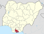
Ahoada West Local Government Area of Rivers State, Nigeria, located Northwest of Port Harcourt. It was extracted in 1996 from the old Ahoada Local Government that makes up the present Orashi Region of Rivers State. Its seat is in the town of Akinima.
The Local Government Area (LGA) comprises the Ekpeyes (Ubies and Ibuduyas), Engenni and
Ogbogolo
communities.
Thus there are three distinct languages namely, Ekpeye, Engenni and Ogbogolo.
The
rain forest. Thus, the occupations of the people are mainly farming, fishing, and hunting.[citation needed
]
Ahoada West Local Government Area is bounded by the following LGAs; Ogba/Egbema/Ndoni Local Government Area, Abua/Odua Local Government Area, Ahoada East Local Government Area on the east, we have Besini and Yenagoa both of Bayelsa State on the North and West respectively. The boundary between Rivers and Bayelsa States from the west is located at Engenni.
References
- ^ "Ahoada West Local Government Area". www.manpower.com.ng. Retrieved 2023-04-25.

