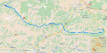
Ailette (river)
Appearance
| Ailette | |
|---|---|
 Center Parcs, Lac d'Ailette area, Chamouile, Aisne, France | |
 | |
| Location | |
| Country | France |
| Physical characteristics | |
| Source | |
| • location | Sainte-Croix |
| • coordinates | 49°29′11″N 03°46′37″E / 49.48639°N 3.77694°E |
| • elevation | 110 m (360 ft) |
| Mouth | |
• location | Oise |
• coordinates | 49°34′40″N 03°09′41″E / 49.57778°N 3.16139°E |
• elevation | 40 m (130 ft) |
| Length | 59.5 km (37.0 mi) |
| Basin size | 540 km2 (210 sq mi) |
| Discharge | |
| • average | 3 m3/s (110 cu ft/s) |
| Basin features | |
| Progression | Oise→ Seine→ English Channel |
The Ailette (French pronunciation: .
On most of its course, it shares its valley with the Canal de l'Oise à l'Aisne.
Communes along its course
This list is ordered from source to mouth:
- Aisne: Sainte-Croix, Corbeny, Craonne, Bouconville-Vauclair, Chermizy-Ailles, Neuville-sur-Ailette, Cerny-en-Laonnois, Chamouille, Pancy-Courtecon, Colligis-Crandelain, Trucy, Chevregny, Monampteuil, Filain, Pargny-Filain, Urcel, Chavignon, Royaucourt-et-Chailvet, Chaillevois, Merlieux-et-Fouquerolles, Vaudesson, Pinon, Lizy, Anizy-le-Château, Vauxaillon, Landricourt, Leuilly-sous-Coucy, Jumencourt, Crécy-au-Mont, Coucy-le-Château-Auffrique, Pont-Saint-Mard, Guny, Champs, Trosly-Loire, Saint-Paul-aux-Bois, Pierremande, Bichancourt, Manicamp, Quierzy
References
