
Almstedt
This article needs additional citations for verification. (February 2024) |
Almstedt | |
|---|---|
Ortsteil of Sibbesse | |
 Coat of arms | |
Location of Almstedt  | |
 Almstedt  Almstedt | |
| Coordinates: 52°02′00″N 9°57′53″E / 52.03333°N 9.96472°E | |
| Country | Germany |
| State | Lower Saxony |
| District | Hildesheim |
| Municipality | Sibbesse |
| Area | |
| • Total | 9.92 km2 (3.83 sq mi) |
| Elevation | 190 m (620 ft) |
| Population (2015-12-31) | |
| • Total | 886 |
| • Density | 89/km2 (230/sq mi) |
| Time zone | UTC+01:00 (CET) |
| • Summer (DST) | UTC+02:00 (CEST) |
| Postal codes | 31079 |
| Dialling codes | 05060 |
| Vehicle registration | HI |
Almstedt is a village and a former municipality in the district of Hildesheim in Lower Saxony, Germany. Since 1 November 2016, it is part of the municipality Sibbesse.[1] Almstedt consists of the village of Almstedt and the smaller village of Segeste. Each of the villages has a sightworthy old church and well-preserved half-timbered houses. The church in Segeste was built in 1770.[citation needed]
-
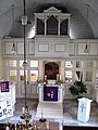
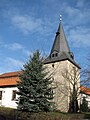 Protestant Church in Almstedt
 -
 Protestant Church in Almstedt
 -
 General view of Segeste
 -
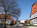 Main street, Segeste
 -
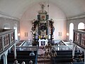
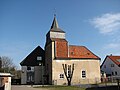 Protestant Church, Segeste
 -
 Protestant Church, Segeste


References
- ^ "Gebietsänderungen von Januar bis Dezember 2016". Statistisches Bundesamt (in German). 16 January 2017. Retrieved 4 February 2024.
Wikimedia Commons has media related to Almstedt.
| International | |
|---|---|
| National | |
Towns and municipalities in Hildesheim district | ||
|---|---|---|
 | ||