Athenree
Athenree | |
|---|---|
Rural settlement | |
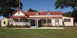
 Athenree Homestead | |
 | |
| Coordinates: 37°26′38″S 175°57′47″E / 37.444°S 175.963°E | |
| Country | New Zealand |
| Region | Bay of Plenty |
| Territorial authority | Western Bay of Plenty District |
| Ward | Katikati-Waihi Beach Ward |
| Community | Waihi Beach Community |
| Electorates | |
| Government | |
| • Territorial Authority | Western Bay of Plenty District Council |
| • Regional council | Bay of Plenty Regional Council |
| Area | |
| • Total | 1.26 km2 (0.49 sq mi) |
| Population (June 2023)[2] | |
| • Total | 920 |
| • Density | 730/km2 (1,900/sq mi) |
Athenree is a rural settlement coastal town in the Western Bay of Plenty District of New Zealand. It is on the northern side of Tauranga Harbour, and separated from Waihi Beach by the Waiau River on its north and east side.[3]
The area includes a holiday park with hot springs[4] and Athenree Wetland, which includes a walking track.[5]
The settlement was named for Athenry in Country Galway, Ireland by settlers arriving in 1878, including Captain Hugh Stewart (a brother of George Vesey Stewart) and his wife, Adela Blanche Stewart, who wrote a book about her experiences called My Simple Life in New Zealand.[6] The settlement was initially successful due to the 1878 opening of the Martha gold mine in Waihi, and later because of dairy farming.[7]
Demographics
Athenree covers 1.26 km2 (0.49 sq mi)[1] and had an estimated population of 920 as of June 2023,[2] with a population density of 730 people per km2.
| Year | Pop. | ±% p.a. |
|---|---|---|
| 2006 | 612 | — |
| 2013 | 675 | +1.41% |
| 2018 | 804 | +3.56% |
| Source: [8] | ||

Athenree had a population of 804 at the
Ethnicities were 92.2% European/Pākehā, 13.8% Māori, 1.1% Pacific peoples, 1.5% Asian, and 2.2% other ethnicities. People may identify with more than one ethnicity.
The percentage of people born overseas was 20.1, compared with 27.1% nationally.
Although some people chose not to answer the census's question about religious affiliation, 56.3% had no religion, 34.7% were Christian, 0.7% had Māori religious beliefs and 1.9% had other religions.
Of those at least 15 years old, 129 (18.9%) people had a bachelor's or higher degree, and 126 (18.5%) people had no formal qualifications. The median income was $26,500, compared with $31,800 nationally. 81 people (11.9%) earned over $70,000 compared to 17.2% nationally. The employment status of those at least 15 was that 246 (36.1%) people were employed full-time, 120 (17.6%) were part-time, and 27 (4.0%) were unemployed.[8]
References
- ^ a b "ArcGIS Web Application". statsnz.maps.arcgis.com. Retrieved 19 November 2022.
- ^ a b "Population estimate tables - NZ.Stat". Statistics New Zealand. Retrieved 25 October 2023.
- ^ Harriss, Gavin (August 2022). Athenree, Bay of Plenty (Map). NZ Topomap.
- ^ "Hot Springs and Holiday Park Accommodation". Retrieved 19 November 2022.
- ^ "Athenree Wetland". Western Bay of Plenty District Council. Retrieved 19 November 2022.
- ^ Hughes, Beryl. "Adela Blanche Stewart". Dictionary of New Zealand Biography. Ministry for Culture and Heritage. Retrieved 19 November 2022.
- ^ Discover New Zealand - A Wises Guide (9th ed.). Wises Publications. 1994. p. 86.
- ^ a b "Statistical area 1 dataset for 2018 Census". Statistics New Zealand. March 2020. Athenree (190400). 2018 Census place summary: Athenree
