
Attalla, Alabama
Attalla | ||
|---|---|---|
FIPS code 01-03028 | | |
| GNIS feature ID | 2403130[3] | |
| Website | www | |
Attalla is a city in
History

The town developed on the area of a former
Cherokee people had also lived in this area, after being encroached on in Tennessee and western North Carolina. David Brown (Cherokee) was assisted by the Rev. D. S. Butterick in preparing the Cherokee Spelling Book while he lived here.
Attalla was not founded until 1870; it was established on land donated by W. C. Hammond, a plantation owner. It was incorporated as a city government on February 5, 1872. The town was officially named "Attalla" in 1893, derived from a Cherokee language word meaning "mountain".[5]
Railroads served the town and connected it to other markets. When the railroads went into bankruptcy, Attalla's prosperity declined in the late 19th century financial troubles.[citation needed]
Attalla is the site of the first hydroelectric dam constructed to provide electricity for a cityi; it was built n 1887.[6]
20th century to present
Geography
Attalla is in Etowah County at 34°0′35″N 86°5′54″W / 34.00972°N 86.09833°W (34.009818, -86.098413).[8] It is bordered to the east by the city of Gadsden, the county seat, and at its southernmost point by Rainbow City.
Interstate 59 runs along the eastern edge of the city, with access from Exits 181 and 183. U.S. Route 11 passes through the center of town as Third Street and runs generally parallel to I-59, leading northeast 36 miles (58 km) to Fort Payne and southwest 58 miles (93 km) to Birmingham. U.S. Routes 278 and 431 also pass through the center of Attalla, leading east 5 miles (8 km) to downtown Gadsden. US 431 runs north 20 miles (32 km) to Albertville, while US 278 leads west 47 miles (76 km) to Cullman. Alabama State Route 77 passes through the southern section of Attalla, leading north 3 miles (5 km) to US 431 and southeast 6 miles (10 km) to Rainbow City.
According to the
Demographics
| Census | Pop. | Note | %± |
|---|---|---|---|
| 1880 | 351 | — | |
| 1890 | 1,254 | 257.3% | |
| 1900 | 1,692 | 34.9% | |
| 1910 | 2,513 | 48.5% | |
| 1920 | 3,462 | 37.8% | |
| 1930 | 4,585 | 32.4% | |
| 1940 | 4,885 | 6.5% | |
| 1950 | 7,537 | 54.3% | |
| 1960 | 8,257 | 9.6% | |
| 1970 | 7,510 | −9.0% | |
| 1980 | 7,737 | 3.0% | |
| 1990 | 6,859 | −11.3% | |
| 2000 | 6,592 | −3.9% | |
| 2010 | 6,048 | −8.3% | |
| 2020 | 5,827 | −3.7% | |
| U.S. Decennial Census[9] | |||
2000 census
At the
The age distribution was 23.7% under the age of 18, 8.9% from 18 to 24, 27.3% from 25 to 44, 22.4% from 45 to 64, and 17.7% 65 or older. The median age was 38 years. For every 100 females, there were 90.2 males. For every 100 females age 18 and over, there were 86.5 males.
The median household income was $27,444 and the median family income was $39,549. Males had a median income of $30,605 versus $19,693 for females. The per capita income for the city was $15,727. About 16.4% of families and 18.6% of the population were below the
2010 census
At the
The age distribution was 22.7% under the age of 18, 8.9% from 18 to 24, 25.0% from 25 to 44, 26.3% from 45 to 64, and 17.2% 65 or older. The median age was 39.8 years. For every 100 females, there were 89.3 males. For every 100 females age 18 and over, there were 94.9 males.
The median household income was $32,426 and the median family income was $35,934. Males had a median income of $33,428 versus $25,441 for females. The per capita income for the city was $16,457. About 13.9% of families and 18.2% of the population were below the
2020 census
| Race | Num. | Perc. |
|---|---|---|
White (non-Hispanic)
|
4,337 | 74.43% |
Black or African American (non-Hispanic)
|
774 | 13.28% |
Native American
|
13 | 0.22% |
Asian
|
33 | 0.57% |
Other/Mixed
|
333 | 5.71% |
Latino
|
337 | 5.78% |
As of the 2020 United States census, there were 5,827 people, 2,151 households, and 1,364 families residing in the city.
Attalla Precinct/Division (1880-1970)
The Attalla Beat (Etowah County 17th Beat) first appeared on the 1880 U.S. Census. In 1890, "beat" was changed to "precinct." In 1960, the precinct was changed to "census division" as part of a general reorganization of counties.[13] In 1980, Attalla census division was consolidated with Gadsden census division.
Education
The Attalla City School System is the public school district. As of 2006 it has some 1,823 students.[14]
The district includes the following schools:
- Attalla Elementary School (Grades Pk-5)
- Etowah Middle School (Grades 6–8)
- Etowah High School (Grades 9-12)
The system formerly had Alma Hinson Junior High School. In 1962 the editor of The Etowah News Journal described the school as having a "nothing short of excellent" curricula and "a bright exception" to problems in other schools in the system.[15]
Notable people
- Gerald William Barrax(1933–2019), poet and educator
- Betty Kelly (born September 16, 1944), member of Motown girl group Martha and the Vandellas
- Larry Means (born April 20, 1947), former member of the Alabama Senate and current mayor
- Patrick Nix (born April 7, 1972), former Auburn University quarterback
- Tyrone Nix (born September 30, 1972), defensive coordinator for the Ole Miss Rebels
- Derrick Nix (born February 22, 1980), defensive coordinator for the Auburn Tigers
- B. L. Noojin (1885–1950), athlete, educator, and politician
- Georgia Institute of Technology
Gallery
-
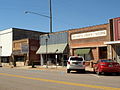 4th Street, Attalla
 -
 Bank of Attalla
 -
 Historic Alabama Power Company sign, Attalla
 -
 5th Avenue, Attalla
 -
 5th Avenue, Attalla
 -
 Country Music Opera House, Attalla
 -
 First United Methodist Church, Attalla
 -
 Seven Cedars, Attalla
 -
 Houses on 5th Avenue, Attalla
 -
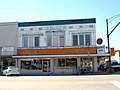 Walker's Drug Store building, Attalla
 -
 Old Attalla Elementary School


References
Notes
References
- ^ City of Attalla official website
- ^ "2020 U.S. Gazetteer Files". United States Census Bureau. Retrieved October 29, 2021.
- ^ a b U.S. Geological Survey Geographic Names Information System: Attalla, Alabama
- ^ a b "Geographic Identifiers: 2010 Demographic Profile Data (G001): Attalla city, Alabama". American Factfinder. U.S. Census Bureau. Archived from the original on February 13, 2020. Retrieved January 21, 2016.
- ^ "The Names Stayed". Calhoun Times and Gordon County News. August 29, 1990. p. 64. Retrieved April 29, 2015.
- ^ "Historic Attalla Alabama". City of Attalla. Retrieved January 21, 2016.
- ^ "A Postman's 1963 Walk For Justice, Cut Short On An Alabama Road". National Public Radio. Retrieved July 15, 2016.
- ^ "US Gazetteer files: 2010, 2000, and 1990". United States Census Bureau. February 12, 2011. Retrieved April 23, 2011.
- ^ "U.S. Decennial Census". Census.gov. Retrieved June 6, 2013.
- ^ "U.S. Census website". United States Census Bureau. Retrieved January 31, 2008.
- ^ "U.S. Census website". United States Census Bureau. Retrieved July 23, 2015.
- ^ "Explore Census Data". data.census.gov. Retrieved December 11, 2021.
- ^ http://www2.census.gov/prod2/decennial/documents/37721510v1p2ch2.pdf, 1960 AL Census
- ^ Attalla City Schools
- Newspapers.com.
External links
34°00′35″N 86°05′54″W / 34.009818°N 86.098413°W
Municipalities and communities of Etowah County, Alabama, United States | ||
|---|---|---|
| Cities |  | |
| Towns | ||
| CDPs | ||
| Unincorporated communities |
| |
| Former City | ||
| Footnotes | ‡This populated place also has portions in an adjacent county or counties | |
| ||
| International | |
|---|---|
| National | |