Bad Sülze
Bad Sülze | |
|---|---|
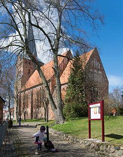
 Gothic church | |
Location of Bad Sülze within Vorpommern-Rügen district Vorpommern-Rügen | |
| Municipal assoc. | Recknitz-Trebeltal |
| Government | |
| • Mayor | Doris Schmutzer |
| Area | |
| • Total | 26.37 km2 (10.18 sq mi) |
| Elevation | 11 m (36 ft) |
| Population (2022-12-31)[1] | |
| • Total | 1,796 |
| • Density | 68/km2 (180/sq mi) |
| Time zone | UTC+01:00 (CET) |
| • Summer (DST) | UTC+02:00 (CEST) |
| Postal codes | 18334 |
| Dialling codes | 038229 |
| Vehicle registration | NVP |
| Website | https://www.stadtbadsuelze.de/ |
Bad Sülze (German: .
Nearby geographical features include a group of three lakes called Torfkuhlen Bad Sülze.
Excavations on the Redderstorfer corridor have shown that a settlement in the area of the present town existed from the Neolithic to Bronze Age and, later, from the Slavic times to the Middle Ages. Bad Sülze is known for its spas and may be the oldest brine and moorbath in northern Germany.[2]
References
- Statistisches Amt Mecklenburg-Vorpommern. 2023.
- ^ "Bad Sülze / Health spas / Spa and health resorts : Bäderverband M-V, die Gesundheitswebsite". www.mv-baederverband.de. Retrieved 2019-12-12.
Wikimedia Commons has media related to Bad Sülze.


