
Barrea
Barrea | |
|---|---|
| Comune di Barrea | |
Location of Barrea  | |
UTC+2 (CEST) | |
| Postal code | 67030 |
| Dialing code | 0864 |
| Patron saint | St. Thomas |
| Saint day | December 21 |
| Website | Official website |
Barrea (Abruzzese: Varréa) is a comune in the province of L'Aquila in the Abruzzo region of Italy.
It is located on the shore of the
History
The village of Barrea descends from the pre-Roman population of the Samnites, who linked their destinies to the village. Currently, along the shores of the lake or in the nearby archaeological site of Alfedena, traces abound from this period. There is a document from the year 996 in which the ancient name of Barrea, Vallis Regia, first appears. This document also mentions that Barrea was given to the Duke of Spoleto during the dark feudal times in Italy, a period noted for its anarchic regimes and barbaric raids.
Perhaps mainly to protect themselves from the fierce raid of the
One side of the original, central castle was protected from invaders by natural means, utilizing the impassably steep slope of the mountain; two stone castle gates afforded other protection to the castle and the homes that were built within its walls, dug into the slides of the mountain and giving out through front entrances facing on narrow, twisting, steep stone alleys.
Its location surrounded by the
Today, Barrea is at the center of the
Gallery
-
 Panoramic view.
 -
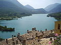 Lake of Barrea.
 -
 The lake during winter.
 -
 Church of the Purgatory.
 -
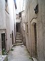 An alley in the village.


.JPG)


References
- ^ "Superficie di Comuni Province e Regioni italiane al 9 ottobre 2011". Italian National Institute of Statistics. Retrieved 16 March 2019.
- ^ "Popolazione Residente al 1° Gennaio 2018". Italian National Institute of Statistics. Retrieved 16 March 2019.
External links