
Beverley Park, New South Wales
| Beverley Park Federal division(s) | Cook | ||||||||||||||
|---|---|---|---|---|---|---|---|---|---|---|---|---|---|---|---|
| |||||||||||||||
Beverley Park is a suburb in southern Sydney, in the state of New South Wales, Australia. Beverley Park is located 15 kilometres south of the Sydney central business district, in the Georges River Council and is part of the St George area.
Beverley Park is surrounded by the suburbs
Kogarah Bay, Carlton, Kogarah, Ramsgate and Sans Souci. It is a predominantly residential area around a large recreational area, Beverley Park Golf Course. It has a few commercial developments scattered along its borders on the Princes Highway
and Rocky Point Road.
History
Beverley Park and
Kogarah Bay were originally part of the suburb of Kogarah. The area had been originally known as Townson's Bay and then Koggorah.[2]
Kogarah and Kogarah Bay were completely separated from each other by the creation of this new suburb. The suburb took its name from the large recreational park, which includes the Beverley Park Golf Course.
Sunnyside is a historic sandstone house on the corner of Princes Highway and Lacey Street, which was originally the home of Matthew Carroll, who owned 179 acres on both sides of the swampy headland of Kogarah bay. A Church of England rectory in the 1930s and a private kindergarten and primary school from 1948. It was sold in 1958 and converted into a rooming house until 1993 when it became a private residence again.
Population
According to the
Sport and recreation
The
St George
Leagues Club is located on Princes Highway. Beverley Park Golf Club covers a large percentage of this suburb's area.
-
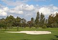 Beverley Park Golf Course
 -
 Sunnyside, Princes Highway


References
- ^ Australian Bureau of Statistics (27 June 2017). "Beverley Park (State Suburb)". 2016 Census QuickStats. Retrieved 25 March 2018.
- ^ "Future is looking bright for colourful, colonial Sunnyside - Local News - News - General - St George & Sutherland Shire Leader". Archived from the original on 20 June 2008. Retrieved 20 June 2008. St George Leader
- ^ "2016 Census QuickStats: Beverley Park". censusdata.abs.gov.au. Retrieved 24 March 2018.
External links
- Alison Grellis (2008). "Beverley Park". Dictionary of Sydney. Retrieved 25 September 2015. [CC-By-SA]