
Blesdijke
Blesdijke | ||
|---|---|---|
Village | ||
Postal code 8398[1] | ||
| Dialing code | 0561 | |
Blesdijke (West Frisian: Blesdike) is a village in Weststellingwerf in the province of Friesland, the Netherlands. It had a population of around 460 in 2008.[3]
History
The village was first mentioned in 1350 as Blesdic, and means dike at a bare spot.[4] Blesdijke developed in late middle ages on the road from Oldemarkt to Noordwolde. The Dutch Reformed church dates from 1843 and has a wooden tower. The building is a replacement for a church which collapsed in 1836.[5]
Blesdijke was home to 393 people in 1840.[6]
Castle Old Stoutenburght is a folly which pretends to be a medieval castle.[7] As of 2021, the castle has four towers and is about 27 metres (89 ft) tall.[6]
Gallery
-
 Street view
 -
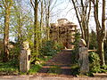 Castle Old Stoutenburght
 -
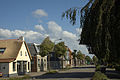 Street view
 -
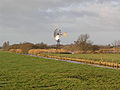 Windmotor


References
- ^ a b c "Kerncijfers wijken en buurten 2021". Central Bureau of Statistics. Retrieved 2 April 2022.
- ^ "Postcodetool for 8398ER". Actueel Hoogtebestand Nederland (in Dutch). Het Waterschapshuis. Retrieved 2 April 2022.
- ^ Villages - Weststellingwerf municipality (in Dutch)
- ^ "Blesdijke - (geografische naam)". Etymologiebank (in Dutch). Retrieved 2 April 2022.
- ISBN 90 400 9476 4. Retrieved 2 April 2022.
- ^ a b "Blesdijke". Plaatsengids (in Dutch). Retrieved 2 April 2022.
- ^ "Old Stoutenburg". Stinsen in Friesland (in Dutch). Retrieved 2 April 2022.
External links
![]() Media related to Blesdijke at Wikimedia Commons
Media related to Blesdijke at Wikimedia Commons
This Friesland location article is a stub. You can help Wikipedia by expanding it. |