
Boligee Hill
Boligee Hill | |
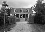
 The house in 1936 | |
  | |
| Nearest city | Boligee, Alabama |
|---|---|
| Coordinates | 32°45′35″N 87°59′20″W / 32.75972°N 87.98889°W |
| Built | 1840 |
| NRHP reference No. | 82002014[1] |
| Added to NRHP | February 19, 1982 |
Boligee Hill, now known as Myrtle Hill, is a historic
sweet myrtle growing around it. The property was restored in 2007 by the Beeker family and renamed Myrtle Hill.[2] The house was placed on the National Register of Historic Places on February 19, 1982, due to its architectural significance.[1]
Gallery
-
 Rear elevation in 1936
 -
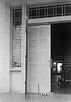 Detail of front entrance
 -
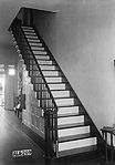 Detail of staircase in entrance hall


References
- ^ a b c "National Register Information System". National Register of Historic Places. National Park Service. April 15, 2008.
- ^ a b "Eutaw Historic Pilgrimage 2007". GreeneAlGenWeb. Archived from the original on January 6, 2009. Retrieved December 10, 2008.
- ^ "Boligee Hill Plantation". Sankofa's African Slave Genealogy. Archived from the original on September 9, 2017. Retrieved September 8, 2017.
External links
![]() Media related to Boligee Hill at Wikimedia Commons
Media related to Boligee Hill at Wikimedia Commons
- Historic American Buildings Survey (HABS) No. AL-209, "Boligee Hill, Near U.S. Highway 11, Eutaw, Greene County, AL", 15 photos, 2 data pages
- Photograph of house taken after restoration
| Topics | |
|---|---|
| Lists by state |
|
| Lists by insular areas | |
| Lists by associated state | |
| Other areas | |
| Related | |
This article about a property in Alabama on the National Register of Historic Places is a stub. You can help Wikipedia by expanding it. |
This article about a plantation in Alabama is a stub. You can help Wikipedia by expanding it. |