
Boligee, Alabama
Boligee, Alabama | ||
|---|---|---|
FIPS code 01-08104 | | |
| GNIS feature ID | 0114691 | |
Boligee
Boligee has one site listed on the National Register of Historic Places, Boligee Hill.[4]
Geography
Boligee is located at 32°45′50″N 88°1′33″W / 32.76389°N 88.02583°W (32.763768, -88.025968).[5]
According to the
Demographics
| Census | Pop. | Note | %± |
|---|---|---|---|
| 1880 | 36 | — | |
| 1930 | 178 | — | |
| 1940 | 241 | 35.4% | |
| 1950 | 168 | −30.3% | |
| 1960 | 134 | −20.2% | |
| 1970 | 225 | 67.9% | |
| 1980 | 164 | −27.1% | |
| 1990 | 268 | 63.4% | |
| 2000 | 369 | 37.7% | |
| 2010 | 328 | −11.1% | |
| 2020 | 301 | −8.2% | |
| U.S. Decennial Census[6] 2010[7] 2020[8] | |||
2020 census
| Race / Ethnicity (NH = Non-Hispanic) | Pop 2010[7] | Pop 2020[8] | % 2010 | % 2020 |
|---|---|---|---|---|
White alone (NH)
|
29 | 26 | 8.84% | 8.64% |
Black or African American alone (NH)
|
295 | 270 | 89.94% | 89.70% |
Alaska Native alone (NH)
|
0 | 0 | 0.00% | 0.00% |
| Asian alone (NH) | 0 | 0 | 0.00% | 0.00% |
| Pacific Islander alone (NH) | 0 | 0 | 0.00% | 0.00% |
| Some Other Race alone (NH) | 0 | 0 | 0.00% | 0.00% |
| Mixed Race or Multi-Racial (NH) | 3 | 5 | 0.91% | 1.66% |
| Hispanic or Latino (any race) | 1 | 0 | 0.30% | 0.00% |
| Total | 328 | 301 | 100.00% | 100.00% |
2000 Census
As of the
There were 150 households, out of which 44.0% had children under the age of 18 living with them, 26.0% were married couples living together, 41.3% had a female householder with no husband present, and 30.0% were non-families. 27.3% of all households were made up of individuals, and 10.0% had someone living alone who was 65 years of age or older. The average household size was 2.46 and the average family size was 2.99.
In the town, the population was spread out, with 35.2% under the age of 18, 14.6% from 18 to 24, 19.8% from 25 to 44, 18.7% from 45 to 64, and 11.7% who were 65 years of age or older. The median age was 25 years. For every 100 females, there were 69.3 males. For every 100 females age 18 and over, there were 60.4 males.
The median income for a household in the town was $15,000, and the median income for a family was $16,146. Males had a median income of $23,750 versus $21,000 for females. The
Notable people
- Emma Didlake, United States veteran
- William P. G. Harding, American banker and managing director of the War Finance Corporation
- Charles Hays, Confederate major who became a Republican Congressman.
- Brad Hubbert, American football player, played in the 1967 American Football League All-Star game.
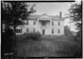
Gallery
Below are photographs taken in Boligee as part of the
-
 Weston House and Schoolhouse
 -
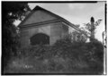 Beth Salem Presbyterian Church
 -
 Hill of Howth
 -
 Old well located at Hill of Howth


References
- ^ "2020 U.S. Gazetteer Files". United States Census Bureau. Retrieved October 29, 2021.
- ^ "Boligee town, Alabama". United States Census Bureau. Retrieved April 15, 2022.
- ^ "Boligee".
- ^ "National Register Information System". National Register of Historic Places. National Park Service. April 15, 2008.
- ^ "US Gazetteer files: 2010, 2000, and 1990". United States Census Bureau. February 12, 2011. Retrieved April 23, 2011.
- US Census Bureau.
- ^ a b "P2 HISPANIC OR LATINO, AND NOT HISPANIC OR LATINO BY RACE – 2010: DEC Redistricting Data (PL 94-171) – Boligee town, Alabama". United States Census Bureau.
- ^ a b "P2 HISPANIC OR LATINO, AND NOT HISPANIC OR LATINO BY RACE – 2020: DEC Redistricting Data (PL 94-171) – Boligee town, Alabama". United States Census Bureau.
- ^ "U.S. Census website". United States Census Bureau. Retrieved January 31, 2008.
32°45′50″N 88°01′33″W / 32.763768°N 88.025968°W
Municipalities and communities of Greene County, Alabama, United States | ||
|---|---|---|
| Cities |  | |
| Towns | ||
| Unincorporated communities | ||
| ||