
Bombay Castle
Bombay Castle (also Casa da Orta) is one of the oldest defensive structures built in the city of
| Bombay Castle | |
|---|---|
| Mumbai | |
 Bombay Castle | |
| Site information | |
| Type | Seaside fort |
| Condition | Preserved |
| Location | |
 Bombay Castle Shown within Mumbai | |
| Coordinates | 18°55′54″N 72°50′17″E / 18.931626049277433°N 72.83814296299832°E |
| Site history | |
| Materials | Kurla Stone |
The castle was built of local blue Kurla stone and red laterite stone from the Konkan region to the south. The islands came under the hands of the English in 1665, and the East India Company took possession of the castle in 1668. Over the next ten years, they built a defensive structure around the manor.
The castle had four Bastions, three of which were originally surrounded completely with water. These were named the Flag Staff Bastion (where a British Flag had been hoisted), The Flower tree Bastion, and the Tank Bastion. The fourth was the Brab Tree Bastion, known for being near a Brab Tree. This would face the West.[3]
Few records of the original Portuguese castle remain and historians are trying to piece together the original location of the manor. Two gates of the manor are located within INS Angre, a naval station in South Mumbai. A sundial thought to date back to the Portuguese era is also present. This sundial does not mark out the 12 hours of a day, but rather marks out certain periods that the people of the time deemed important.
The main building within the castle was the Governor's House, in which
Gallery
-
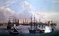 Ships in Bombay Harbour, 1731. The Castle can be seen at the right
 -
 Bombay fort from the sea
 -
 Entrance to the Bombay Fort
 -
 Bombay Castle Gateway, 1891


See also
- Fort George, Mumbai
- Dongri Fort
References
- Governor of Maharashtra, Official website.
- Indian Express.[dead link]
- ^ "QGIS2leaf webmap". cityresource.in. Retrieved 18 August 2024.
- ^ "The History of Raj Bhavan, Mumbai". Raj Bhavan Maharashtra. Archived from the original on 6 October 2014. Retrieved 30 September 2014.
- Times Group. p. 4. Retrieved 30 September 2008.[dead link]