
Boulainvilliers station
You can help expand this article with text translated from the corresponding article in French. (November 2022) Click [show] for important translation instructions.
|
Boulainvilliers | |||||||||||
|---|---|---|---|---|---|---|---|---|---|---|---|
| RER station | |||||||||||
 Platforms | |||||||||||
| General information | |||||||||||
| Location | 52, Rue des Vignes 16th arrondissement of Paris, 75116 France | ||||||||||
| Coordinates | 48°51′23″N 2°16′31″E / 48.85639°N 2.27528°E | ||||||||||
| Elevation | 40 m (130 ft) | ||||||||||
| Owned by | SNCF | ||||||||||
| Operated by | SNCF | ||||||||||
| Line(s) | |||||||||||
| Platforms | 2 | ||||||||||
| Tracks | 2 | ||||||||||
| Bus routes |
| ||||||||||
| Bus operators | RATP, Noctilien | ||||||||||
| Connections |
| ||||||||||
| Other information | |||||||||||
| Station code | 87543181 | ||||||||||
| Fare zone | 1 | ||||||||||
| History | |||||||||||
| Opened | 12 April 1900 | ||||||||||
| Services | |||||||||||
| |||||||||||
| Location | |||||||||||
 | |||||||||||
Boulainvilliers is a station in
La Muette on Paris Métro Line 9
is connected to the RER station via an underground passageway.
-
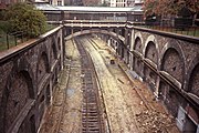 The old rails of the Auteuil line – Champ-de-Mars connection being removed in 1984 as part of the conversion to the RER C. This is at the old Boulainvilliers station.
 -
 Station entrance


See also
- List of stations of the Paris RER
- List of stations of the Paris Métro
External links
Wikimedia Commons has media related to Gare de Boulainvilliers.
- Boulainvilliers station at Transilien, the official website of SNCF (in French)
| |||||||||||
| |||||||||||
48°51′23″N 2°16′31″E / 48.856456°N 2.275149°E
This Réseau Express Régional article is a stub. You can help Wikipedia by expanding it. |