
Brandywell, Isle of Man
| Brandywell, Isle of Man | |
|---|---|
 B10 Beinn-y-Phott Road looking towards Brandywell, Slieau Dhoo mountain and Mount Karin. | |
| Coordinates | 54°14′53.9″N 4°32′27.3″W / 54.248306°N 4.540917°W |
| Built | 1864-65, 1894-96, 1935, 1938 (road) |
 Location of Brandywell, Isle of Man in Isle of Man | |
Brandywell, Isle of Man (
Location and description
The area of Brandywell is open moorland situated in the Northern Uplands of the Isle of Man including the commons grazing land of Slieau-ny-Maggle Intack (archaic North Park)[7] and Injerbreck Hill close to the private residence of ‘Brandywell Cottage’[8] a former Mountain Shepherd's Cottage.[9][10]
The area of Brandywell includes the secondary B10 Beinn-y-Phott Road, the B25 West Baldwin Road, B10 Brandywell / Sartfell Road with the junction with the B26 Ballaugh Glen (Druidale) Road at ‘Brandywell Cottage.’ The area is dominated by the nearby Snaefell Mountain with an elevation of 621 m (2,037 ft) above sea level and the nearby summits of Beinn-y-Phott 544 metres (1,785 ft), Sartfell 454 metres (1,490 ft), Slieau Maggle 427 metres (1,401 ft) and nearby Injerbreck Hill 399 metres (1,309 ft). The Sulby river has its source here,[11] which flows into the nearby Sulby Reservoir (capacity 4,837 million litres), built in 1983.[12]
Area of Specific Scientific Interest
The mountain moorland of the Beinn-y-Phot uplands including Brandywell, Injebreck Hill, Slieau Maggle mountain and part of Druidale adjacent to the Sulby reservoir is an Area of Specific Scientific Interest (ASSI) and upland conservation "hot-spot."[13] The area of Brandywell and the adjacent Brandywell junction with A18 Snaefell Mountain Road, the Beinn-y-Phott uplands, Snaefell, Mullagh Ouhr and Clagh Ouhr mountains is the largest continuous area of grassland moorland of 2,654.60 hectares (6,559.7 acres) found on the Isle of Man.[14]
Origin of Name
The name Brandywell originates from a nearby water-well.[15][16] For the adjacent property of ‘Brandywell Cottage,’ the publication, A Gazetteer of the Isle of Man writes about a local story:
"...a rich Manxman, who had been successful abroad, hired men to work here. To demonstrate his wealth, he filled the local well with Brandy."[17]
Brandywell in the parish of Kirk Michael was also a place where local mountain shepherds would gather to celebrate Forester's Day[18] and to brand and sort flocks of mountain sheep including the castration of male lambs.[19][20]
The Manx name Chibbyr Slieau Maggle or Chibber slew ne Magerell means "the well at the mountain of testicles", referring to the castration of sheep at this location.[21]
Brandywell Corner, A18 Snaefell Mountain Road
The Brandywell Corner, previously the 'Mountain Gate,'
The publication, A Gazetteer of the Isle of Man writes:
"....Brandywell Road ....This name has been adopted by the motor cycle fraternity for the sweeping left hand bend.....where the B10 leaves the TT course (A18) a short distance on from Hailwood Rise. The OS Landranger Map 95 further confuses by marking this place as Brandywell."[27]
A18 Snaefell Mountain Road
The A18 Snaefell Mountain Road was developed in the mid-nineteenth century from a number of pre-existing roads, carting-tracks and horse-paths.[28] This included installation of a number of sheep-gates including the Beinn-y-Phott sheep-gate near the Brandywell Corner road junction.[29] This section of the A18 Snaefell Mountain Road from the Keppel Gate northwards to (North Barrule) was built following a recommendation in a report to Tynwald made by the Disafforesting Commission of 1860. The A18 road was built on crown commoners grazing land that transferred to the UK Crown following the sale of the Islands feudal rights by John Murray, 4th Duke of Atholl in 1824.[30]
The Brandywell Corner was subject to road widening with the removal of the Beinn-y-Phott sheep-gate on the A18 Mountain Road for the 1935 Isle of Man TT Races.[31]
Via Regia footpath and the Millennium Way
The footpath at Brandywell Corner is an ancient
Motor-sport heritage
The Iron Gate section of A18 Snaefell Mountain Road near to the Brandywell road junction was part of the 52.15 mile
In 1911 the Four Inch Course for automobiles was first used by the Auto-Cycling Union for the Isle of Man TT motorcycle races.[36] This included the revised Brandywell Corner and the course later became known as the 37.73 mile Isle of Man TT Mountain Course which has been used since 1911 for the Isle of Man TT Races and from 1923 for the Manx Grand Prix races.[37]
Brandywell Cottage and Brandywell Jumps
For timed special stages for the Rally Isle of Man and Manx Rally including the former Manx International Rally and Manx Trophy Rally the area of Brandywell and Brandywell Cottage for motor-sport spectators is described as "….a natural amphitheatre."[38] This includes the B10 Brandywell Road/ C37 Druidale double hairpin at Brandywell Cottage, the B22 West Baldwin ‘link road’ and the adjoining ".....famous Brandywell ‘Jumps’......"[39] The B10 Brandywell Road with its junction with the A18 Snaefell Mountain Road at the Brandywell Corner has also been used as part of a special timed stages for the Rally Isle of Man.[40]
Mountain bikes
The B10 Beinn-y-Phott road section near to the 'Brandywell Cottage'[41] forms the first official manned check-point of Brandywell at 33 kilometres (20.51 mi) for the Isle of Man End-to-End Mountain Bike Challenge.[42][43] The largest single day mountain bike race in Europe, the 75 kilometres (46.60 mi) route races from the Point of Ayre in the north of the Isle of Man to Port Erin in the south of the Island.[44]
The Isle of Man Cyclefest Gran Fondo cycling event[45] consists of an 82.50 miles (132.77 km) figure of eight course. The cross-over point for the northern and southern loops for the Cycling and Mountain Bike section of the cycling race is at Brandywell Cottage.[46] The southern loop of the Gran Frodo event from Baldwin Bridge to Brandywell Cottage contains the 5.4 kilometres (3.36 mi) ‘Injebreck Hill’ climb (average gradient 6%) as featured in the cycling publication "Another 100 Greatest Cycling Climbs."[47]

The Brandywell Corner road junction forms part of two official mountain bike routes. The first A Grand Day Out (cross country loop) a mountain bike trail of 18.5 miles follows the B10 Brandywell Road and the A18 Snaefell Mountain Road and is classified as a Red difficult route.[48] The second official route is the St Luke's & Windy Corner (cross country loop) a mountain bike trail of 17 miles and is also classified as a Red difficult route.[49]
Weather
There is a small automated Weather Station located to the side of the Isle of Man TT Marshall station at the Brandywell Road Junction, along with a similar weather station at the Mountain Box near to the East Snaefell Mountain Gate. It is currently being used by the Isle of Man Department of Infrastructure and the Brandywell weather station is 425 metres (1,394 ft) above sea level near the highest point of the A18 Snaefell Mountain Road. The automated weather station utilises the TT Marshal's telephone line for digital transmission of weather data and due to the absence of an electricity supply is powered by solar panels and a small wind turbine.[50] In 2005, the Brandywell Junction weather station recorded a wind speed gusts of 97 knots (180 km/h; 112 mph)[51] and in 2017 during the extratropical cyclone of ex-Hurricane Ophelia, recorded a gust of 81 knots (150 km/h; 93 mph).[52]
Gallery
-
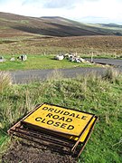 B26 Ballaugh Glen (Druidale) Road at the ‘Brandywell Cottage’ double-hairpin with a north-east aspect towards Slieau Dhoo mountain and Mount Karin.

Sources
- ISBN 3-484-40138-9(Gesamtwerk) 3-484-40130-3 (Band 2) Druck und Eiband: Weihert-Druck GmbH Darmstadt. "Chibbyr y punch (on Slieau Maggle) AM/C SC38NW SC34728650").
- ISBN 3-484-40138-9(Gesamtwerk) 3-484-40130-3 (Band 2) Druck und Eiband: Weihert-Druck GmbH Darmstadt "Chibber slew ne Magerell LCB 1704. ‘Slieau Maggle well.' "
- ^ Manx Uplands and Steering Group – Issues and Opportunities (1:200,000) page 44, 53–56 & Map page 54 Scale 1:200,000 (April 2014) Isle of Man Department for Environment, Food and Rural Affairs – Rheynn Chymmyltaght, Bee as Eirinys (DEFRA)
- ISBN 978-0-85323-577-4
- ^ Manx Uplands and Steering Group – Issues and Opportunities page 4 & map page 13, (Scale 1:200,000) page 43, 53–54 (April 2014) Isle of Man Department for Environment, Food and Rural Affairs – Rheynn Chymmyltaght, Bee as Eirinys (DEFRA) – "Defining the Manx Uplands....all areas of ‘AML’ defined land("Above the mountain line", 250m above sea level), all land above 200m.... all areas of heathland, woodland and water catchment contiguous with the 200m contour."
- ^ Ramsey Courier page 6 Friday 7 October 1960
- ISBN 3-484-40138-9(Gesamtwerk) 3-484-40130-3 (Band 2) Druck und Eiband: Weihert-Druck GmbH Darmstadt. Slieau Maggle ONB1956 SC38NW
- ISBN 0 951 4539 12
- ^ Manx Independent – Manninagh Seyr page 23 Thursday 13 October 2016 Isle of Man Newspapers Ltd (2016) Tindle Press Publishing ISSN 1358-4391 Newsprint (Knowsley) Ltd
- ^ Mona’s Herald page 5 Murder in Lonely Farmhouse Wednesday 15 October 1930 "Brandywell Cottage was found to be empty, marks were made so that if anyone enters the cottage the police will be able to tell of the visit. All the searches are armed."
- ^ Andrew Johnson, "The Early Exploitation of the Upper Sulby Valley", Proceedings of the Isle of Man Natural History and Antiquarian Society, 10 (4): 327
- ^ Strategic Business Plan 1999 to 2009 and beyond - Part 1 Executive Summary page 13 4.1 Impounding Reservoirs - Isle of Man Water Authority Lught-Reill Ushtey Ellan Vannin January 1999
- ^ Guidelines for the selection of biological Areas of Special Scientific Interest (ASSIs) on the Isle of Man Volume 2: Detailed habitat and species criteria page 108 The Isle of Man Department of Agriculture, Fisheries and Forestry (2008) (DAFF)
- ^ Isle of Man Ecological Habit Survey Phase 1 1991-1994 final report 1996 4.2.2 Acid grassland page 22 T. Sayle MSc, J. Lamb MSc, A. Colvin BSc, B. Harris BSc Isle of Man Department of Agriculture, Fisheries and Forestry - Rheynn Eirinys, Eeastaght as Keylljyn (DAFF) 1995
- ^ Jenkinson’s Practical Guide to the Isle of Man page 119 by Henry Irwin Jenkinson (1874) Edward Stanford, London.
- ^ Manx Sun page 24 Local News Saturday 22 September 1888 "After toiling up Injebreck Hill, noticing on the way the old well, Slieu Maggie, and wondering who had inhabited the defunct cottage on the brow of the hill...."
- ISBN 0 951 4539 12
- ISBN 3-484-40138-9(Gesamtwerk) 3-484-40130-3 (Band 2) Druck und Eiband: Weihert-Druck GmbH Darmstadt. "Chibber y phunch....On the Forester’s Day (?) the shepherds were wont to gather here, and one or two enterprising individuals would dispense hot punch at a remunerative figure....").
- ISBN 3-484-40138-9(Gesamtwerk) 3-484-40130-3 (Band 2) Druck und Eiband: Weihert-Druck GmbH Darmstadt. "Slieau Maggle....Here, according to OT sheep were brought for castration..."
- ISBN 1-873120-25-7"The mountain road junction by Injebreck Hill, named after a well in the vicinity where shepherds used to gather for the sorting and branding of their mountain sheep."
- ^ George Broderick (2010), "A Grammar of Manx Place-names", The Journal of Scottish Name Studies, 4: 28
- ^ Round the TT Course with Harold Daniell R.R. Holliday Motor Cycling (c1947) Castrol Oils That Lap at 91! Harold L.Daniell, TT Record Holder. Tells How it was done.
- ^ TT Pioneers – Early Car Racing in the Isle of Man page 27 Robert Kelly, Mercury Asset Management (1996) ( 1st Edition) The Manx Experience, The Alden Press ISBN No 1 873120 61 3
- ^ Isle of Man Times page 1 Friday 1 June 1956
- ^ Place Names of the Isle of Man by John J. Kneen MA (1970) Yn Cheshaght Ghailckagh The Scolar Press – page 173-175 and Map Kirk Braddan page 199, page 209-210 and Map Kirk Onchan page 238, pages 241–242 and Map Kirk Lonan page 271 and pages 202–203 Sheading of Garff page
- ^ Isle of Man Examiner page 4 9 September 2008
- ISBN 0 951 4539 12
- ^ Isle of Man Examiner page 5 Thursday 5 June 1969
- ^ Isle of Man Examiner page 4 9 December 1925 "MOTOR-CYCLE RELIABILITY RUN - The proposed course is via Anxfell, Laxey....Ramsey, Sulby, Tholty-y-Will, Bungalow and then to Nobles Gate and turn right to Brandywell over Injebreck Mountain...."
- ISBN 1-873120-58-3
- ^ Isle of Man Weekly Times dated 25 May 1935
- ^ Ramsey Courier page 6 The Old Manx Roads Friday 6 October 1961
- ISBN 1-899602-72-0Walk 22 - Millennium Way Ancient ridgeway Cronica - Regum Mannie et Insulaum.
- ^ TT Pioneers – Early Car Racing in the Isle of Man page 22 Robert Kelly, Mercury Asset Management (1996)(1st Edition) The Manx Experience, The Alden Press ISBN No 1 873120 61 3
- ^ The Manx Experience. A Souvenir Guide to the Isle of Man. page 66-67 Gordon N. Kniverton, 8th edition, The Manx Experience (1987) Mannin Publishing Ltd
- ^ Round the TT Course with Harold Daniell R.R. Holliday Motor Cycling (c1947) Castrol Oils That Lap at 91! Harold L.Daniell, TT Record Holder. Tells How it was done.
- ISBN 1 901508 04 8
- ^ European Rally Championship for Drivers CO-EF 4 Manx International Rally 1986 Official Programme 10 –13 September 1986 page 15 Manx International Rally Ltd (1986) RAC Motor Sports Association - Isle of Man Tourist Board – Print Centres Ltd, Braddan.
- ^ European Rally Championship for Drivers CO-EF 20 1988 Manx International Rally Official Programme 13 – 16 September 1988 page 16 Manx International Rally Ltd (1988) RAC Motor Sports Association Isle of Man Tourist Board – Print Centres Ltd, Braddan.
- ^ Public Notice - Manx International Rally 2004 ROADS CLOSED TO THE PUBLIC B.W. Hannay Director of Transport, Isle of Man Department of Transport (2004) Mannin Printing - Stage 17 Druidale, Brandywell. The C37 Druidale Road from its junction with the Ballaugh Glen Road to its junction to the B10 Brandywell Road at Brandywell Cottage. The Brandywell Road from its junction with the Druidale Road to its junction with the A18 Snaefell Mountain Road."
- ^ Manx Independent – Manninagh Seyr page 56, 57 & 64 CYCLING SPORTS - ENDtoEND Thursday 14 September 2017 Isle of Man Newspapers Ltd (2017) Tindle Press Publishing ISSN 1358-4391 Newsprint (Knowsley) Ltd
- ^ Programme 2017 End 2 End Mountain Bike Challenge What you need to Know page 5 (2017) Manx Mountain Bike Club
- ^ Isle of Man Courier – Roieder Ellan Vannin page 40 2 September 2016 Isle of Man Newspapers Ltd (2016) Tindle Press Publishing
- ^ http://www.end2end.im
- ^ Isle of Man Examiner – Brialtagh Ellan Vannin page 33 Final Whistle Isle of Man Newspapers Ltd (2017) Johnson Press Publishing – Sheffield Web 16 May 2017
- ^ Isle of Man Cyclefest 2017 Intro, Page 9 & 15 Gary Thompson Clerk of the Course: Isle of Man Cyclefest Ltd (2017) Isle of Man Department of Economic Development ROAD CLOSURES & TRAFFIC RESTRICTIONS.
- ISBN 978-0-7112-3265-5
- ^ Isle of Man Mountain Biking Guide – 8 complete self-guided routes page 3 Visit Isle of Man (2014) Isle of Man Department of Economic Development – "....Before you enter the open moorland, be sure to take a few minutes to soak up the magnificent view.... The rough descent to the road makes up part of the End 2 End Course and should be tackled with care. At the B10, turn left and follow this road through the cattle grid and on towards the TT Course. As you join the TT Course at Brandywell, you will see your starting point just half a mile to the north."
- ^ Isle of Man Mountain Biking Guide – 8 complete self-guided routes page 6 Visit Isle of Man (2014) Isle of Man Department of Economic Development – "This tough eastern course combines parts of the Millennium Way with the famous TT Course and some wild landscapes..... At the T junction turn right towards St Luke’s Church. At the church take the track on its right hand side and head north on this section of the Millennium Way. This is a long and steady climb that eventually brings you out on to the B10. Turn right and follow the B10 east towards the Mountain Road (TT Course)."
- ^ Isle of Man Examiner – Brialtagh Ellan Vannin KEEPING AN EYE ON THE WEATHER page 4 Monday 9 September 2008 ".....The Mountain Box and Brandywell marshal huts/weather stations are owned and maintained by the DoT....." ISSN 1358-4383
- doi:10.1002/wea.36"....stronger winds were recorded over the northern part of the island...but the two high level road weather stations near Snaefell recorded higher gusts, 88kt (101 mph) at Mountain Box (400 meters AMSL) and 97kt (112 mph) at Brandywell (425 meters AMSL)."
- ^ Manx Independent – Manninagh Seyr page 6 Thursday 19 October 2017 Isle of Man Newspapers Ltd (2017) Tindle Press Publishing Newsprint (Knowsley) Ltd ISSN 1358-4391