
Brick Lane
51°31′19″N 0°4′18″W / 51.52194°N 0.07167°W

Brick Lane (
Today, it is the heart of the country's
History

15th to 18th centuries
The street was formerly known as Whitechapel Lane, and wound through fields. It derives its current name from brick and tile manufacture started in the 15th century, which used the local
Brewing came to Brick Lane before 1680, with water drawn from deep wells.
Successive waves of immigrants settled in the area. In the 17th century, French
19th-century markets and their modern use

In the 19th century, Irish people[7] and Ashkenazi Jews immigrated to the area.[8] Jewish immigration continued into the early 20th century.
The Sunday market, like those on
In 2015 it was identified by police as the focal point of a trade in stolen
In the later 20th century,
Religious groups
In 1742,
Reflecting the changing demographics of the area, in 1898, the building was consecrated as the Machzikei HaDath, or Spitalfields Great
Bengali settlement


In the 20th century the Brick Lane area was important in the second wave of development of
Bengalis in the United Kingdom settled in big cities with industrial employment. In London, many settled in the East End. For centuries the East End has been the first port of call for many immigrants working in the docks and shipping from
Designed by Meena Thakor, the ornamental Brick Lane Arch was erected in 1997 near Osborn Street to mark the entrance to Brick Lane and to 'Banglatown'. Like Brick Lane's lamp posts, the arch displays the red and green colours of the Bangladesh flag.[17] Having contributed so significantly to the area, the Bengali community campaigned to get the arch installed to celebrate Bengali culture in Brick Lane.[18]
Regeneration
.jpg)
More recently the area has also broadened to being a vibrant art and fashion student area, with considerable exhibition space. Each year most of the fine art and fashion courses exhibit their work near Brick Lane.
Since the late 1990s, Brick Lane has been the site of several of the city's best known
Brick Lane has a regular display of graffiti, which features artists such as
Land ownership and naming

Large swathes of Brick Lane and its surrounding areas were once owned by the Osborne (later Osborn after 1720) family, Baronets, of Chicksands in the County of Bedford. The family's holdings survived until at least the 1970s. The family's history continues to be reflected by the naming of streets in the area around Brick Lane, including:
- Chicksand Street reflects the village of Chicksands in Bedfordshire, location of the family seat Chicksands Priory;
- The west end of what is now Chicksand Street was once Osborn Place (see 1787 map);
- Modern Osborn Street is a renaming of what was once the southernmost stretch of Brick Lane (see Rocque map of 1746for this naming, altered by the time of the 1787 map);
- Heneage Street reflects the marriage of George Osborn, 4th Baronet, to Lady Heneage Finch (his 2nd wife) in April 1772;[23]
- The modern Hopetown Street was originally Finch Street, reflecting the same marriage (see 1853 map, right);
- The modern Old Montague Street was originally just Montague Street, preserving the maternal family name of George Osborn, 4th Baronet, whose mother, Mary Montague, was the daughter of George Montague, 2nd Earl of Halifax.[23] The continuation of Chicksand Street to the east (now demolished) was once Halifax Street, referencing the same marriage;
- Modern Hanbury Street is made up of four streets shown on the 1853 map: Browns Lane, Montague Street (triggering the addition of 'Old' to the earlier street of the same name), Well Street and Church Street.
-
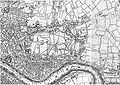 John Rocque's Map of London, 1746
 -
 Map, publisher unknown, dated 1787, showing Spitalfields ("Spittlefields") and its environs
 -
 An extract from Cross's New Plan Of London, showing Stepney and surrounding areas. Published 1853 by J. Cross of London.


Buildings of interest
Nearby buildings of interest include
Transport

The nearest
The nearest
In popular culture

The street is the location for
Other notable books on the area are Salaam Brick Lane by Tarquin Hall,[26] On Brick Lane (2007) by Rachel Lichtenstein and An Acre of Barren Ground by Jeremy Gavron.[27] A large collection of photographs of the characters and salespeople who worked on the markets in Brick Lane were taken by Fran May between 1976 and 1978, whilst she was a student of photography at the Royal College of Art.[28]
The street was used for several filming locations for the third season of the BBC television series Luther (2013).[citation needed]
See also
- Beigel Bake
- British Bangladeshi
- Green Street, London
- Balti Triangle, Birmingham, also known as 'The Halal Quarter'
References
- ^ Spitalfields and Banglatown (London Borough of Tower Hamlets) Archived 25 October 2007 at the Wayback Machine accessed 1 November 2007
- ^ "Stepney: Economic History", A History of the County of Middlesex, Volume 11: Stepney, Bethnal Green (1998), pp. 52-63 Retrieved 15 October 2007
- ^ "Bethnal Green: The West: Shoreditch Side, Spitalfields, and the Nichol", A History of the County of Middlesex, Volume 11: Stepney, Bethnal Green (1998), pp. 103-109 Retrieved 15 October 2007.
- ^ Robert Bard. Whitechapel & Stepney Through Time. Stroud: Amberley Publishing, 2014. Retrieved 30 January 2018.
- ^ The Black Eagle Brewery, Brick Lane, Survey of London: volume 27: Spitalfields and Mile End New Town (1957), pp. 116-122 Retrieved 15 October 2007.
- ^ "Bethnal Green: Settlement and Building to 1836", A History of the County of Middlesex, Volume 11: Stepney, Bethnal Green (1998), pp. 91-5 Date Retrieved 17 April 2007
- ^ John A. Jackson, The Irish in Britain, 137-9, 150 (Routledge & Kegan Paul, 1964)
- ^ "The Jews", A History of the County of Middlesex, Volume 1: Physique, Archaeology, Domesday, Ecclesiastical Organization, The Jews, Religious Houses, Education of Working Classes to 1870, Private Education from Sixteenth Century (1969), pp. 149-51 Date Retrieved 17 April 2007
- London Evening Standard. p. 18.
- ^ 'Brick Lane Farmers Market Opens', LFM
- ^ "London Farmers' Markets | Brick Lane Farmers' Market".
- ^ The Spatial Form of Bangladeshi Community in London's East End Iza Aftab (UCL) Archived 27 February 2008 at the Wayback Machine (particularly background of Bangladeshi immigration to the East End). Date Retrieved 17 April 2007
- ^ Michael Smith, John Eade (2008). Transnational Ties: Cities, Migrations, and Identities. Transaction Publishers. pp. 148-149.
- ^ Lucy Dixon, "A brief history of the Mosque" Archived 28 August 2007 at the Wayback Machine, My Tower Hamlets website, Retrieved 15 October 2007
- ^ Historic England. "Brick Lane Jamme Masjid (former Neuve Eglise) (1240697)". National Heritage List for England. Retrieved 14 April 2009.
- ^ "London's Brick Lane: an insider's guide". EasyJet | Traveller. Retrieved 3 November 2021.
- ^ "Bengali Cultural Walk" (PDF). Tower Hamlets Local History Library and Archives. Archived (PDF) from the original on 5 January 2018.
- ^ "Spitalfields Neighbourhood Plan 2020-2035" (PDF). Tower Hamlets Council.
- ^ "Bringing Colour to the Block". Hookedblog — UK Street Art. Retrieved 21 March 2016.
- Independent.co.uk. 7 March 2011.
- ^ "Brick Lane: Chinese political slogans appear on London street art wall". BBC News. 7 August 2023. Retrieved 8 August 2023.
- ^ Kottasová, Ivana; Gan, Nectar (8 August 2023). "Chinese propaganda slogans turn London street art wall into a protest site against Beijing]". CNN. Retrieved 8 August 2023.
- ^ a b Cokayne (compiler), G.E. (1904). The Complete Baronetage, Volume 3. Exeter, UK: William Pollard & Co Ltd. pp. 243–44.
- ^ "Bid to name Tube stop Brick Lane". BBC News. 15 December 2006. Retrieved 10 January 2007.
- ^ Cacciottolo, Mario. "Brick Lane protesters hurt over 'lies'", BBC News, 31 July 2006.
- ^ "Interview: author Tarquin Hall - Brick Lane". Icons of England. Archived from the original on 2 November 2007.
- ^ Myerson, Julie (1 April 2005). "Review: An Acre of Barren Ground by Jeremy Gavron". The Guardian. Archived from the original on 13 April 2023.
- ^ "Fran May Gallery". franmay.com. Archived from the original on 4 December 2018.
External links
- Brick Lane entry at the Survey of London (1957)
- Brick Lane through the last two hundred years, including many genealogical pubs.
- Virtual e-Tour Brick Lane
- Our Brick Lane - Eastside Community Heritage