
Broeltowers
| Broel Towers | |
|---|---|
Courtrai, Belgium | |
| Coordinates | 50°49′49″N 3°16′1″E / 50.83028°N 3.26694°E |
| Completed | 1385 1415 (expansion) |
The Broel Towers (Dutch: Broeltorens) are a listed monument and a landmark in the Belgian city of Kortrijk (Courtrai). The towers are known as one of the most important symbols of the city.
History
Although they look identical, the towers were not built at the same time. The Southern tower, also known as the Speyetoren, was built in 1385 to control the traffic on the river
The Northern tower, known as the Ingelborchtoren was built in 1415 and was used as an
Nowadays, the towers are, together with the Artillerytower (in Dutch: Artillerietoren), the last remaining parts of the
A statue of John of Nepomuk can be found in the middle of the bridge spanning between the two towers. This statue of the patron saint of the drowned has, ironically, fallen into the river Lys on several occasions due to warfare in the city. The bridge between the two towers was destroyed in both world wars.
Gallery
-
![The Broel towers and Broel Bridge [nl]](//upload.wikimedia.org/wikipedia/commons/thumb/7/71/Kortrijk-Courtrai.jpg/120px-Kortrijk-Courtrai.jpg) The Broel towers and Broel Bridge
The Broel towers and Broel Bridge -
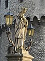 John of Nepomuk statue on the Broel Bridge
 -
 The 'Speytorre' (l.) and the 'Inghelburghtorre' (r.)
 -
 The Inghelburghtorre (1415)
 -
 The 'Speytorre' or 'Blauwe Toren' (1385)
![The Broel towers and Broel Bridge [nl]](/File:Kortrijk-Courtrai.jpg)


