
Kortrijk
Kortrijk
| ||
|---|---|---|
City and municipality | ||
   .jpg) Clockwise from top: Theatre Square (Schouwburgplein) during Summer Carnival, Beguinage and Saint Martin's Church, Broeltowers, Kortrijk City Hall as seen from the Grote Markt | ||
|
Coat of arms | ||
Location of Kortrijk  | ||
 Kortrijk Location in Belgium
Location of Kortrijk in West Flanders Region Flemish Region | | |
| Province | West Flanders | |
| Arrondissement | Kortrijk | |
| Government | ||
| • Mayor | Vincent Van Quickenborne (Open VLD) | |
| • Governing party/ies | Team Burgemeester, Vooruit, N-VA | |
| Area | ||
| • Total | 80.69 km2 (31.15 sq mi) | |
| Population (2022-01-01)[1] | ||
| • Total | 77,741 | |
| • Density | 960/km2 (2,500/sq mi) | |
| Postal codes | 85xx (8500, 8501, 8510, 8511) | |
| NIS code | 34022 | |
| Area codes | 056 | |
| Website | www.kortrijk.be | |
Kortrijk (.
With its 79,000 inhabitants (2023) Kortrijk is the capital and largest city of the judicial and administrative
The city is on the river

Courtrai originated from a Gallo-Roman town, Cortoriacum,[8] at a crossroads near the Leie river and two Roman roads. In the Middle Ages, Courtrai grew significantly thanks to the flax and wool industry with France and England and became one of the biggest and richest cities in Flanders. The city is often referred to as City of Groeninge or City of the Golden Spurs, referring to the Battle of Courtrai or the Battle of the Golden Spurs which took place on 11 July 1302 on the Fields of Groeninge in Courtrai. In 1820 the Treaty of Kortrijk was signed, laying out the still-current borders between France and Belgium. Throughout the 19th and 20th century, the flax industry flourished and remains important within the Belgian textile industry today.
Courtrai is the largest city in southern West Flanders, with several hospitals, colleges and a university. Courtrai was the first city in Belgium with a pedestrian shopping street, the Korte Steenstraat.
History
Name
The Latin name Cortoriacum[8] means the settlement near the curb in the river.[citation needed] There is also mention of 'Cortoracum' in some literature. Its name later evolved to 'Cortrycke', 'Cortryck' and 'Kortrijk' (19th century). In French and in English, the city is called Courtrai.
Origins Roman times
Findings from an archeological dig in 1950 in which remains of three Roman
Cortoriacum was a larger

In the 13th century, the battles between
Battle of the Golden Spurs
In 1302, the population of
Following a new uprising by the Flemish in 1323, this time against their own Count Louis I, the French invaded again. These Flemish acquisitions were consolidated by the French at the Battle of Cassel (1328).
Louis I's son
15th century to modern times
Most of the 15th century was prosperous under the
The 16th century was marked by the confrontations engendered by the
After the French Revolution and the Napoleonic era, the textile industry, based on flax, and the general economy of the city prospered again.
Courtrai was heavily bombed in the summer of 1917, but
Battle of Courtrai
Battles fought there in 1302, 1382, 1580, 1793, 1794, 1814, 1815, and 1918 have each been called Battle of Courtrai.
Geography
Municipality
After the 1977 fusion the city is made up of:
Neighbouring municipalities
The metropolitan area, including the outer commuter zone, also consists of Kuurne, Wevelgem, Zwevegem and Harelbeke. Although these municipalities have strong morphologic ties with Courtrai, they aren't officially part of the city.
 |
|
Climate
Kortrijk has an oceanic climate (Köppen Cfb).
| Climate data for Kortrijk (1981–2010 normals, sunshine 1984–2013) | |||||||||||||
|---|---|---|---|---|---|---|---|---|---|---|---|---|---|
| Month | Jan | Feb | Mar | Apr | May | Jun | Jul | Aug | Sep | Oct | Nov | Dec | Year |
| Mean daily maximum °C (°F) | 6.0 (42.8) |
6.9 (44.4) |
10.7 (51.3) |
14.3 (57.7) |
18.1 (64.6) |
20.7 (69.3) |
23.2 (73.8) |
23.1 (73.6) |
19.6 (67.3) |
15.2 (59.4) |
9.9 (49.8) |
6.4 (43.5) |
14.6 (58.3) |
| Daily mean °C (°F) | 3.5 (38.3) |
3.8 (38.8) |
6.7 (44.1) |
9.4 (48.9) |
13.2 (55.8) |
16.0 (60.8) |
18.2 (64.8) |
18.1 (64.6) |
14.9 (58.8) |
11.2 (52.2) |
7.0 (44.6) |
4.0 (39.2) |
10.5 (50.9) |
| Mean daily minimum °C (°F) | 0.8 (33.4) |
0.6 (33.1) |
2.8 (37.0) |
4.5 (40.1) |
8.5 (47.3) |
11.4 (52.5) |
13.5 (56.3) |
13.0 (55.4) |
10.3 (50.5) |
7.3 (45.1) |
4.0 (39.2) |
1.6 (34.9) |
6.6 (43.9) |
| Average precipitation mm (inches) | 70.2 (2.76) |
54.9 (2.16) |
63.6 (2.50) |
50.5 (1.99) |
63.7 (2.51) |
71.9 (2.83) |
76.3 (3.00) |
71.3 (2.81) |
68.4 (2.69) |
77.1 (3.04) |
81.1 (3.19) |
80.1 (3.15) |
829.2 (32.65) |
| Average precipitation days | 12.7 | 10.6 | 12.3 | 9.9 | 11.1 | 10.1 | 10.1 | 9.5 | 10.7 | 11.9 | 13.3 | 13.0 | 135.3 |
| Mean monthly sunshine hours | 59 | 79 | 122 | 177 | 205 | 200 | 214 | 202 | 149 | 119 | 65 | 49 | 1,639 |
| Source: Royal Meteorological Institute[13] | |||||||||||||
Main sights


Architecture
Much of the city's
Civil
- Medieval Kortrijk City Hall on the main square, the Grote Markt. The façade of the late-Gothic, early Renaissance city hall is adorned with the statues of the Counts of Flanders.
- The belfry is surmounted by a statue of Mercury, god of the merchants. The belfry is classified by UNESCO as a World Heritage Site, on the list of Belfries of Belgium and France.[14]
- Near-identical medieval Leie. (the Speyetower and the Ingelburgtower)
- Artillerytower (Artillerietoren)
- Mont de Piété(Berg van Barmhartigheid or house of Mercy)
- Weigh house (Stadswaag) on the St.Michael-square
- Our Lady Hospital (Onze-Lieve-Vrouwehospitaal), founded in 1200–1204.
- Baggaertshof, often called Kortrijk's second Beguinage, contains a Botanical garden
- Groeningekouter contains the Groeningegate and the Groeninge Monument, to commemorate the 600th anniversary of the famous Battle of the Golden Spurs
Religious
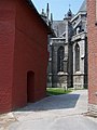
- The Saint-Martin church dates from the 13th century but was mostly rebuilt after a fire in the 15th century. It now houses a 48-bell carillon. Its 83-meter (272 feet) tower remains the highest building in the city.
- The beguinage is one of the quaintest sites in the city. It too, was listed by UNESCO as a World Heritage Site, on the list of "Flemish Béguinages".[15]
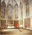
- The church of Our Lady (Onze-Lieve-Vrouwekerk) is former collegiate church. Here the golden spurs taken from the battlefield in 1302 were hung. It houses a rich interior with an altar piece of van Dyck.
- the Count’s chapel (Louis II of Flanders.
- Saint-Michaelschurch; a church of the Society of Jesus
- Saint-Johnschurch in the St.-Johnsquarter; a Neo-Gothic basilica
- Groeninge Abbey
- Saint Eligiuschurch
- Saint-Pius X-church
- Saint-Rochchurch
- Saint-Elisabethchurch
- Saint-Anthonychurch or Toontjes kerk with the pilgrimage of Isidore of Saint Joseph
- Saint-Annechurch
- Saint-Theresiachurch
- Father Damienchurch
Museums
Museums in Courtrai include:
- Kortrijk 1302: seven centuries in one day, a historic museum about the famous Battle of the Golden Spurs, which gave Flanders its official holiday (11 July)
- Broelmuseum (Museum of Fine Arts and archaeological museum), with paintings by Roelant Savery and international Ceramic.
- National Flax Museum in honour of the plant that once was the main driver of Kortrijk’s economy. This museum will be relocated.
- Groeninge Abbey with the Groeningemuseum. This museum gives you an overview of Kortrijk's history.
- Beguinage museum located in the old town, in the béguinage.
- Flemish Film museum and archive
- Bakery- and Millmuseum, located in an old windmill.
- Museum of Agriculture
- International Rose gardens, located in the park of the Castle t Hooghe, in the Hoog-Kortrijk quarter just in front of Kortrijk Xpo.
- Begijnhofmuseum
Transport
Road
Courtrai lies at the intersection of three highways:
- The E17: connects Courtrai with Ghent, Sint-Niklaas and Antwerp to the northeast, and with Lille and Paris to the south-west.
- The E403: connects Courtrai with Bruges and Ostend to the north, and with Tournai, Mons and Charleroi to the south-east.
- The Belgian highway A19: connects Courtrai with Ypres and the Belgian coast.
- In addition Courtrai also has two ringways:
Railway
- The municipality of Courtrai has two railway stations:
- Lille in France. The station also offers a direct connection to Brussels Airport.
- Bissegem Station: a regional railway station in the village of Bissegem with connections to Ypres.
Public city transport
Kortrijk has an extensive web of public transport lines, operated by De Lijn, providing access to the city centre and the suburbs (city lines, Dutch: stadslijnen) and to many towns and villages in the region around the city (regional lines, Dutch: streeklijnen).
- City buses:
- Line 1: Station – Kortrijk Xpo – Kinepolis – Leiedal
- Line 2: Station – Lange Munte
- Line 4: Station – Bissegem Station – Heule Kransvijver
- Line 50: Station – Kuurne Seizoenswijk
- Line 51: Station – Kuurne Sint-Pieter
- Line 6: Station – Shopping Center (– Industriezone) – Heule Markt
- Line 9: Station – Cederlaan
- Line 12: Station – Kinepolis – Bellegem – Rollegem (– Aalbeke)
- Line 13: Station – Hoog Kortrijk
- Line 80/81: Station – Marke
- Line 91/92/93: Station – Zwevegem
- Regional buses
- At Kortrijk main railway station, there is a bus station where regional buses stop as well.
Airport
- The city has an airport known as Kortrijk-Wevelgem International Airport, which is mainly used for business travel and medical flights. Kortrijk Airport is located northwest of the city centre, next to the R8 ringroad.
- The national Brussels Airport, one hour away by train or car, offers the best international connectivity.
- The Lille Lesquin International Airportis located 35 kilometres from Kortrijk.
Waterways

The
Within the City, the river briefly splits in two, to re-join about a mile further.
- Oude Leie (Old Lys) original southernmost riverbed where the Broel towers still stand.
- Nieuwe Leie (New Lys) New bed that was dug around 1585 by Humans to accommodate water powered equipment.[citation needed][16]
From the 1970s on, the planning and later the execution of the so-called Leiewerken (Leieworks) started. These construction works comprised the deepening and widening of the river. This would enable ships with 4400 tons to navigate from France to the Scheldt. At the same time, this project included a thorough urban renewal of the riversides in the city. Seven new bridges were to give a new architectural impulse to the river quarters as well as the construction of several new parks along the river.
The following bridges were built during the period of 1997 and 2012:
- Dambrug
- Groeningebrug near the AlbertPark
- Ronde van Vlaanderenbrug near the new Nelson Mandelapark
- Collegebrug referring to the St Amands college
- Noordbrug (2010)
- Budabrug
- Reepbrug (to be constructed)
More recently (2018), the banks in front of the
Other Smaller Waterways with Historic and Geological value
Several small streams or Beken in and around Courtrai were of significant topological, historical and Geological value.[17]
- Lange Mere Mentioned in the Town accounts of 1412-13 as Langhe Meere.
- Mosscher (High Mossher and Low Mosscher) ending in the Southern Moat (Sanderus Map[18] mentions only the Mosscher as a single toponym. It was also mentioned in almost full length on the Deventer Map.[19]
- Groeninghe (first mentioned as Groeninc in 1412[citation needed] ) Its name came from the green color of the flooded meadow where it originated.
- Grote Vijver (first mention as Hoghen vivere in the town accounts of 1416-17).
- St-Jan's stream - Human dug connecting stream
- Klakkaert stream
- Moat around the City (south of the Leie or Lys)
- Neveldries
- Bloedmeers
Cycling and pedestrian areas
Cars are required to give way to pedestrians and cyclists. In general, cars are led to large underground car parks in the historic centre of Courtrai or Park&Ride parking outside the town centre. Large parts of the historic centre are car free.
Economy
The city is historically connected with the flax and the textile industry, and still today the textile industry remains important in the region. Major companies which have headquarters in Courtrai include
Education
Courtrai serves as an educational centre in south West Flanders, attracting students from the entire region.
There are 55 schools in Courtrai, on 72 different locations throughout the city, with an estimated 21,000 students.[20]
The city also provides higher education. The
European cooperation
Even though Courtrai is a Dutch-speaking town, it borders
- Courtrai is a member of the Eurotowns network.[21]
Demographics
| Group of origin | Year | |
|---|---|---|
| 2023[22] | ||
| Number | % | |
| Belgians with Belgian background | 59,756 | 75.69% |
| Belgians with foreign background | 10,794 | 13.67% |
| Neighboring country | 1,638 | 2.07% |
| EU27 (excluding neighboring country) | 700 | 0.89% |
| Outside EU 27 | 8,456 | 10.71% |
| Non-Belgians | 8,394 | 10.63% |
| Neighboring country | 1,164 | 1.47% |
| EU27 (excluding neighboring country) | 1,747 | 2.21% |
| Outside EU 27 | 5,483 | 6.95% |
| Total | 78,944 | 100% |
Culture

Newspaper
- Courtrai used to have its own newspaper in times of war, called het Kortrijks Oorlogsblad.
Music
- Courtrai has widely recognised local artists, such as:
- Fapy Lafertin, foremost exponent of the Belgian-Dutch style of gypsy jazz.
- Goose, electronic rock band with international projection.
- Amenra, extreme metal band prominent in the European metal scene.
- Marcel Ponseele, baroque oboist known for his Bach performances and recordings.
- Balthazar, indie rock band popular in both Belgium and the Netherlands.
- Michaela Karadjian, soprano Opera singer.
Theatres and concert venues

- Courtrai has several cultural centres, each comprising different locations:
- Cultural Centre Kortrijk
- City Theatre (De Schouwburg), a neo-Renaissance architecture theatre on Schouwburgplein known for its glass ceiling, an artwork of the French-Algerian artist Alberola
- Arenatheatre
- Antigone Theatre
- Buda Kunstencentrum (Buda Arts Centre), comprising the cinema Budascoop, the artist residence Tacktower and the artist creation space Budafactory
- The Concertstudio
- Music Centre Track*
- Concert venue De Kreun
- Cinemas
- Kinepolis, a modern cinema multiplex with 10 screens.
- Budascoop, a 5 screen cinema, specialised in European movies.
Festivals and events
The city is host to some sizable cultural events such as:
- Day of the Flemish Community (11 July)
- Golden River City Jazz Festival (first weekend of September)
- Humorologie: cabaret festival
- Next: arts festival in the Eurodistrict Kortrijk-Lille-Tournai
- Happy New Ears: festival of experimental modern music
- Budafest: theatre festival
- The Internationaal Festival van Vlaanderen (April–May): several concerts of classical and modern music.
- Novarock: rock festival in Kortrijk Xpo
- Easter Carnival (Paasfoor): during the weeks after Easter
- Sinxenfestival: one of the most vivid festivals downtown with street artists, concerts and flea markets all over town
- Kortrijk Congé (July)
- Alcatraz Hard Rock & Metal Festival (August)
- Summer Carnival (weekend in August)
- Student Welcome Concert: rock festival to celebrate the start of the new academic year at the Kortrijk University and the Kortrijk Colleges.
Also, trade shows and events such as the international Design Fair
In July and August there are various boat tours on the river
Food
Local specialities include Kalletaart (apple cake with
brewery.Leisure
Shopping

- Kortrijk was the first town in Belgium to have a fully traffic-free shopping street, the Korte Steenstraat (1962). Later, a lot of neighbouring streets were also made traffic-free. As a result, Courtrai nowadays has one of the biggest traffic-free areas in Belgium (comprising Lange Steenstraat, Steenpoort, Sint-Jansttraat, Wijngaardstraat and several squares).
- Courtrai has several indoor shopping malls including the Ring Shopping Kortrijk Noord, Bouwcentrum Pottelberg and and many other clothes, food and houseware stores.
Parks

- Beguinagepark
- Groeningepark, on the site of the Groeningekouter where the Groeningegate and the Groeninge Monument
- King Albertpark, with the Leiemonument which commemorates the Battle of the Lys
- Gebroeders van Raemdonckpark
- Queen Astridpark in the Overleie district
- 't Plein, a nineteenth-century park, laid out on a former military site
- Park de Blauwe Poort
- Magdalenapark
- Rozentuin, the International Rose Garden
- Stadsgroen Messeyne
- Kasteelpark Blommeghem
- Kasteelpark 't Hooghe
- Nolfpark
- Stadsgroen Venning, with a butterfly garden
Sports
Football
Kortrijk has three official football clubs.
- Belgian First Division A after winning the championship in the former Belgian Second Divisionduring the 2007–2008 season.
- SV Kortrijk plays in the fourth provincial division.
- Wikings Kortrijk is for youth teams.
Basketball
- Kortrijk Sport CB
- Basketbalteam Kortrijk
- House of Talent Spurs
Cycling
- In Flanders generally, professional cycling is very popular. Many cycling races start, finish or pass through the Kortrijk area. Amongst them are the Driedaagse van West-Vlaanderen, Kuurne–Brussels–Kuurne, Gent–Wevelgem, the Tour of Flanders and Dwars door Vlaanderen. Kortrijk also hosts an after-tour criterium at the start of August called Kortrijk Koerse. Many of the riders who participated in the Tour de France usually appear at the start. In cyclo-cross, the centre of Kortrijk hosts the Urban Cross, currently part of the X²O Badkamers Trophy.
Rugby
Tennis
- Tennis Club De Egelantier
Swimming
- KZK, Kortrijkse Zwemkring, arguably the best waterpoloteam in Belgium, having won the Belgian championship nine times. In the 2007–2008 season they won both the championship and the Belgian cup.
Notable citizens
- Emmanuel de Bethune, former mayor (1987–1989) and (1995–2000)[25]
- Hendrik Beyaert, architect
- Francis Bonaert, architect
- John II of Brienne, Count of Eu
- Rob Claeys, footballer
- Carl Colpaert, director, founder of Cineville.
- Hendrik Conscience, writer
- Laurence Courtois, tennis player
- Edmée Daenen, pop artist
- former Minister of Justice
- Jos De Cock, Belgian-French painter, watercolorist, etcher and sculptor.
- Nico F. Declercq, physicist and professor
- Gustave Léonard de Jonghe, portrait painter
- landscape painter
- Carl de Keyzer, photographer
- Pierre de La Rue, Renaissancecomposer
- Sophie de Schaepdrijver, historian
- Vincent De Vos (1829–1875), painter
- European law Professor, European thinker
- Ann Demeulemeester, fashion designer
- Stijn Devolder, road bicycle racer
- Ernest Gambart, art publisher and dealer
- Guido Gezelle, poet
- Robert Gillon (1884–1972), lawyer, politician
- Piet Goddaer, singer-composer, mostly under the name:Ozark Henry
- Calcutta
- The members of electro rock band Goose
- Leif Hoste, road bicycle racer
- beatifiedby Pope John Paul II in 1984
- Franco-Flemish composer of the Renaissance
- Greg LeMond, US professional cyclist – retired
- Xavier Malisse, tennis player
- Morris (1923–2001), cartoonist, creator of Lucky Luke
- Hanne Gaby Odiele (b. 1988), model
- Tom Omey (b. 1975), middle-distance runner
- Jan Palfyn (1650–1730), doctor, surgeon and inventor of the forceps
- Marcella Pattyn, the last traditional Beguine
- Jean-Jacques Pieters, jazz musician
- conceptual artist
- Jan Robbe (1980–), electronic artist and founder of Entity
- Louis Robbe (1806–1887), painter
- Roelant Savery (1576–1639), painter
- Stijn Streuvels (1871–1969), writer
- Franco-Flemish composer of the Renaissance
- Guido van Gheluwe (b. 1926), founder of the Orde van den Prince
- minister of enterprise
- judoka, former world champion and Olympic silver medalist
- Stoffel Vandoorne, Formula E racing driver
- Peter Verhoyen, flautist and piccolo player
- inventor
Town twinning
This section needs additional citations for verification. (July 2015) |
Courtrai participates in
 Bad Godesberg, Germany, since 1964
 Cebu City, Philippines, since 2005
 Frascati, Italy, since 1967
 Greenville, South Carolina, United States, since 1991
 Saint-Cloud, France, since 1993
 Lahore, Pakistan, since 1993
 Tashkent, Uzbekistan, since the late 1980s
 Maidenhead, United Kingdom, since 1981
 Wuxi, China, since 2007
Photo gallery
-
 The Patriapalace
 -
 The Saint-Martenstower
 -
 House in Empire style
 -
 The old town (The Gun Powder Tower, De Kruittoren)
 -
 TheGroeningegate
 -
 Count's Chapel
 -
 Old houses in the historical city centre
 -

-
 The Saint-Elooi church


Notes
- ^ "Bevolking per gemeente op 1 januari 2022". Statbel.
- ^ a b "Courtrai". Merriam-Webster.com Dictionary.
- ^ "Internet site of the town of Izegem". Archived from the original on 2 October 2008. Retrieved 7 September 2011.
- ^ "An inventory of locations suitable for wind energy in Flanders region". Archived from the original on 1 October 2011. Retrieved 7 September 2011.
- ^ List of municipalities : http://fr.eurometropolis.eu/qui-sommes-nous/territoire.html Archived 2015-03-21 at the Wayback Machine
- ^ "EUROMETROPOLIS : Eurometropolis Lille-Kortrijk-Tournai, the 1st European cross-bordrer metropolis". Archived from the original on 2014-09-08. Retrieved 2014-09-08.
- ^ (in French) Populationdata.net Archived 2008-10-09 at the Wayback Machine, Palmarès des plus grandes villes du monde – page 3
- ^ a b "CORTORIACUM (Courtrai) Belgium". The Princeton Encyclopedia of Classical Sites. Perseus Digital Library. Archived from the original on 2020-01-17. Retrieved 2018-06-08.
- ^ "Archeologisch vooronderzoek Kortrijk – Morinnestraat" (PDF). All-Archeo. Archived from the original (PDF) on 2018-06-12. Retrieved 2018-06-08.
- ^ Fegley, 124
- ^ Courtrai (Flem. Kortrijk), a walled town of Belgium, on the Lys, 54 miles SW. of Brussels by rail, and 6 from the French frontier. It has a fine eld bridge flanked with towers, a noble townhall (1526), belfry, and a beautiful Gothic church, founded in 1238 by Baldwin, Count of Flanders. Table damask, linen, and lace are the chief manufactures. Population, about 35,000. Here, in 1302, the citizens of Ghent and Bruges won over the French the 'Battle of the Spurs,' so named from the number of gilt spurs gathered from the dead. Chambers's Concise Gazetteer Of The World, by David Patrick. W. & R. Chambers, Limited, 1906.
- ^ From De Standaard 17/07/09 Kortrijk is bombardement na 65 jaar nog niet vergeten
- ^ "Klimaatstatistieken van de Belgische gemeenten" (PDF) (in Dutch). Royal Meteorological Institute. Archived (PDF) from the original on 17 November 2018. Retrieved 30 May 2018.
- ^ UNESCO. "Belfries of Belgium and France". Archived from the original on 2008-05-21. Retrieved 2008-01-26.
- ^ UNESCO. "Flemish Béguinages". Archived from the original on 2008-03-16. Retrieved 2008-01-26.
- ^ AC02717376, Anonymus (1966). Acta Historiae Neerlandica. Brill Archive.
{{cite book}}: CS1 maint: numeric names: authors list (link) p.11 - ISBN 978-0-85115-888-4.pp. 135-150
- ^ Sanderus, Antonius (1586-1664) Cartographe (1600). "Castellaniae Corturiacensis tabula / Ant. Sanderus". Gallica. Archived from the original on 2018-07-06. Retrieved 2018-07-06.
{{cite web}}: CS1 maint: numeric names: authors list (link) - ^ Deventer, 1545, Jacob van (2012-09-20), English: Kortrijk, map by Jacob van Deventer, archived from the original on 2023-07-11, retrieved 2018-07-06
{{citation}}: CS1 maint: numeric names: authors list (link) - ^ "Duurzame Mobiliteit – Stimuleer de opmaak van schoolvervoerplannen". Duurzamemobiliteit.be. Archived from the original on 2012-02-25. Retrieved 2012-02-10.
- ^ "Eurotowns". Archived from the original on 2023-01-29. Retrieved 2012-11-19.
- ^ "Origin | Statbel". statbel.fgov.be. Archived from the original on 2023-07-02. Retrieved 2023-07-04.
- ^ "Kortrijks oorlogsblad". lib.ugent.be. Archived from the original on 2020-11-24. Retrieved 2020-09-28.
- ^ "RC Curtrycke". Archived from the original on 2010-01-11. Retrieved 2010-06-01.
- ^ "Kortrijk betreurt het overlijden van haar ere-burgemeester". Kortrijk civic site. 2011. Archived from the original on 2 January 2013. Retrieved 7 November 2011.
- ^ "071218 Cubelplan 2007–2012" (PDF). Archived from the original (PDF) on October 1, 2011. Retrieved 2012-02-10.
References
- Fegley, R. (2002). The Golden Spurs of Kortrijk: How the Knights of France Fell to the Foot Soldiers of Flanders in 1302, 2007. McFarland and Company Inc.
External links
- Official website – Information available in Dutch, French, English and German
- Kortrijk airport
- Kortrijk photo gallery
Places adjacent to Kortrijk | |
|---|---|
| Bruges |  | |
|---|---|---|
| Diksmuide | ||
| Kortrijk | ||
| Ostend | ||
| Roeselare | ||
| Tielt | ||
| Veurne | ||
| Ypres | ||
| ||
| International | |
|---|---|
| National | |
| Geographic | |
| Other | |