
Byron, Minnesota
- There are also two Byron Townships in Minnesota.
Byron | ||
|---|---|---|
FIPS code 27-09154[4] | | |
| GNIS feature ID | 2393488[3] | |
| Website | [1] | |
Byron is a city in
Local industries are in the form of
History
Byron was platted in 1864.[7] [8] A post office called Byron has been in operation since 1868.[9] Byron was incorporated in 1873.[7] Before the town was established, a small community known as Bear Grove was west of present-day Byron.
Geography
According to the United States Census Bureau, the city has a total area of 2.91 square miles (7.54 km2), all land.[10]
Climate
| Climate data for Byron 4N, Minnesota (1991–2020 normals, extremes 1993–2018) | |||||||||||||
|---|---|---|---|---|---|---|---|---|---|---|---|---|---|
| Month | Jan | Feb | Mar | Apr | May | Jun | Jul | Aug | Sep | Oct | Nov | Dec | Year |
| Record high °F (°C) | 55 (13) |
61 (16) |
80 (27) |
89 (32) |
96 (36) |
97 (36) |
103 (39) |
97 (36) |
92 (33) |
93 (34) |
77 (25) |
65 (18) |
103 (39) |
| Mean daily maximum °F (°C) | 22.6 (−5.2) |
27.4 (−2.6) |
40.2 (4.6) |
55.0 (12.8) |
67.6 (19.8) |
77.9 (25.5) |
81.2 (27.3) |
79.1 (26.2) |
72.0 (22.2) |
58.2 (14.6) |
41.9 (5.5) |
28.3 (−2.1) |
54.3 (12.4) |
| Daily mean °F (°C) | 13.0 (−10.6) |
16.8 (−8.4) |
30.0 (−1.1) |
43.3 (6.3) |
55.7 (13.2) |
66.2 (19.0) |
69.7 (20.9) |
67.2 (19.6) |
59.4 (15.2) |
45.9 (7.7) |
32.3 (0.2) |
19.7 (−6.8) |
43.3 (6.3) |
| Mean daily minimum °F (°C) | 3.5 (−15.8) |
6.1 (−14.4) |
19.7 (−6.8) |
31.5 (−0.3) |
43.8 (6.6) |
54.5 (12.5) |
58.1 (14.5) |
55.3 (12.9) |
46.8 (8.2) |
33.5 (0.8) |
22.8 (−5.1) |
11.1 (−11.6) |
32.2 (0.1) |
| Record low °F (°C) | −36 (−38) |
−40 (−40) |
−26 (−32) |
7 (−14) |
20 (−7) |
32 (0) |
40 (4) |
33 (1) |
24 (−4) |
12 (−11) |
−11 (−24) |
−26 (−32) |
−40 (−40) |
| Average precipitation inches (mm) | 1.02 (26) |
1.12 (28) |
2.09 (53) |
3.62 (92) |
4.31 (109) |
5.27 (134) |
4.63 (118) |
4.80 (122) |
3.47 (88) |
2.44 (62) |
1.90 (48) |
1.32 (34) |
35.99 (914) |
| Average snowfall inches (cm) | 8.8 (22) |
9.6 (24) |
8.8 (22) |
1.2 (3.0) |
0.6 (1.5) |
0.0 (0.0) |
0.0 (0.0) |
0.0 (0.0) |
0.0 (0.0) |
0.1 (0.25) |
2.8 (7.1) |
12.5 (32) |
44.4 (113) |
| Average precipitation days (≥ 0.01 in) | 6.5 | 5.8 | 7.5 | 10.0 | 13.3 | 13.5 | 10.7 | 11.2 | 10.0 | 9.4 | 5.9 | 7.2 | 111.0 |
| Average snowy days (≥ 0.1 in) | 7.3 | 5.6 | 3.5 | 1.1 | 0.1 | 0.0 | 0.0 | 0.0 | 0.0 | 0.2 | 2.0 | 6.0 | 25.8 |
| Source: NOAA[11][12] | |||||||||||||
Demographics
| Census | Pop. | Note | %± |
|---|---|---|---|
| 1880 | 222 | — | |
| 1890 | 291 | 31.1% | |
| 1900 | 347 | 19.2% | |
| 1910 | 272 | −21.6% | |
| 1920 | 302 | 11.0% | |
| 1930 | 323 | 7.0% | |
| 1940 | 341 | 5.6% | |
| 1950 | 385 | 12.9% | |
| 1960 | 660 | 71.4% | |
| 1970 | 1,419 | 115.0% | |
| 1980 | 1,715 | 20.9% | |
| 1990 | 2,441 | 42.3% | |
| 2000 | 3,500 | 43.4% | |
| 2010 | 4,914 | 40.4% | |
| 2020 | 6,312 | 28.4% | |
| U.S. Decennial Census[13] | |||
2010 census
As of the
There were 1,796 households, of which 44.7% had children under the age of 18 living with them, 60.7% were married couples living together, 11.6% had a female householder with no husband present, 3.8% had a male householder with no wife present, and 23.9% were non-families. 18.9% of all households were made up of individuals, and 4.6% had someone living alone who was 65 years of age or older. The average household size was 2.73 and the average family size was 3.15.
The median age in the city was 33.1 years. 31.1% of residents were under the age of 18; 7.4% were between the ages of 18 and 24; 29.8% were from 25 to 44; 24.3% were from 45 to 64; and 7.3% were 65 years of age or older. The gender makeup of the city was 49.4% male and 50.6% female.
Transportation
Byron has in town and local community to community transportation provided by Rolling Hills Transit. The transportation is fare based and rides can be schedule by call their office or visiting their website at rhtbus.com.
A commuter bus service to Rochester is operated by
The DM&E rail line was originally built by the Winona and St. Peter Railroad, which reached west through town to neighboring
Community and government
Byron has a mayor and a four-member city council. There are also four other government boards including an economic development authority and a park board. Byron City Hall is near the elementary school on 10th Avenue. It is also a fairly new structure. The old city hall is in the center of town at Byron Avenue and 4th Street and was built in 1938.[16] The city's first water tower was built next to that location in 1935, and torn down around 2004. The Byron city flag consists of three stripes of blue, white, and green. It has five stars on the top blue stripe, and a bear in the center of the white stripe. The flag's design was chosen in a citywide contest and the winning design was designed by Jeff and Allison Ihrke.
The weekly Byron Review newspaper covers city events. It is owned by Community News Corporation, which also operates papers in Hayfield and Dodge Center.
Parks and recreation
Parks
One of the major parks in the county,
Byron has several city parks, a public pool open in the summer, and many recreational fields, such as soccer and baseball fields.[17]
Golf
Byron is home to Somerby Golf Club and Community, a private golf club and community on the north side of the city. Links of Byron was a nine-hole public course that closed in 2015.
References
- ^ "Official Website for the City of Byron Minnesota". Official Website for the City of Byron Minnesota. Retrieved October 4, 2012.
- ^ "2020 U.S. Gazetteer Files". United States Census Bureau. Retrieved July 24, 2022.
- ^ a b U.S. Geological Survey Geographic Names Information System: Byron, Minnesota
- ^ "American FactFinder". United States Census Bureau. Archived from the original on 2020-02-12. Retrieved 2008-01-31.
- ^ "Township Information". Olmsted County. Archived from the original on December 31, 2009. Retrieved January 4, 2010.
- ^ "2010 Census Redistricting Data (Public Law 94-171) Summary File". American FactFinder. United States Census Bureau. Retrieved April 27, 2011.[dead link]
- ^ a b Upham, Warren (1920). Minnesota Geographic Names: Their Origin and Historic Significance. Minnesota Historical Society. p. 385.
- ^ Chicago and North Western Railway Company (1908). A History of the Origin of the Place Names Connected with the Chicago & North Western and Chicago, St. Paul, Minneapolis & Omaha Railways. p. 50.
- ^ "Olmsted County". Jim Forte Postal History. Retrieved July 27, 2015.
- ^ "US Gazetteer files 2010". United States Census Bureau. Archived from the original on January 12, 2012. Retrieved 2012-11-13.
- ^ "NOWData - NOAA Online Weather Data". National Oceanic and Atmospheric Administration. Retrieved April 2, 2024.
- ^ "Summary of Monthly Normals 1991-2020". National Oceanic and Atmospheric Administration. Retrieved April 2, 2024.
- ^ "Census of Population and Housing". Census.gov. Retrieved June 4, 2016.
- ^ "American FactFinder". United States Census Bureau. Archived from the original on February 12, 2020. Retrieved November 13, 2012.
- ^ "Olmsted County Minnesota Railroad Stations".
- ^ "History". Byron, Minnesota. Retrieved December 31, 2009.
- ^ "Welcome to the City of Byron Parks!". www.byronmn.com. Retrieved April 26, 2020.
External links
Municipalities and communities of Olmsted County, Minnesota, United States | ||
|---|---|---|
| Cities | 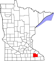 | |
| Townships | ||
| CDPs | ||
| Unincorporated communities | ||
| Footnotes | ‡This populated place also has portions in an adjacent county or counties | |
| ||
| Core city |  | |
|---|---|---|
| Incorporated Places | ||
| Counties | ||
‡ indicates that it is partially in the metropolitan area. † indicates a county seat. | ||