
Côte d'Argent

Côte d’Argent (French: [kot d‿aʁ.ʒɑ̃]; lit. 'Silver Coast') is a name given to part of the Atlantic coast of the Aquitaine region in France.
Etymology
The term was first coined to describe the Aquitaine coast in 1905 by the journalist and poet Maurice Martin. The Congrès national des sociétés de géographie officially approved the name in 1907. The region it referred to eventually shrunk; the northern part including Royan became the Côte de Beauté and the southern part including Anglet became the Basque Coast.[1]
Geography
In the south-west of France, facing the Atlantic Ocean, La Côte d’Argent is part of the Bay of Biscay. It is limited at its north by the Gironde mouth and at its south by the river Adour. Large waves make this a popular surfing destination and create some of the largest sand dunes in Europe, including the Dune of Pilat.[2][3] Surfing competitions include the Quiksilver Pro France and the Lacanau Pro.
-
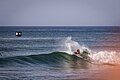
 Surfing in Capbreton
 -
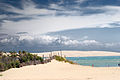 Dune of Pilat from Cap Ferret
 -
 Quiksilver Pro France
 -
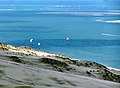 View from Dune of Pilat
 -
 Lacanau Pro


.jpeg)
.jpg)

Towns

Towns and resorts along the Côte d’Argent include:
Gironde
- Soulac-sur-Mer
- Vendays-Montalivet
- Hourtin
- Carcans
- Lacanau
- Le Porge
- Lège-Cap-Ferret
- Arcachon
- Pyla-sur-Mer
Landes
- Biscarrosse
- Mimizan, nicknamed the "Pearl of the Côte d’Argent"
- Contis
- Lit-et-Mixe
- Vielle-Saint-Girons
- Moliets-et-Maa
- Messanges
- Vieux-Boucau-les-Bains
- Seignosse
- Soorts-Hossegor
- Capbreton
- Labenne
- Ondres
- Tarnos
Pyrénées-Atlantiques
See also
- Arcachon Bay
- The Great Dune of Pyla
References
- ^ Bertho-Lavenir, Catherine; Latry, Guy (2007). "Côte d'Argent, Côte d'Émeraude : les zones balnéaires entre nom de marque et identité littéraire". Cairn (in French). Retrieved 8 April 2021.
- ^ "Striking silver on France's Côte d'Argent". On the Luce. 19 August 2015. Retrieved 8 April 2021.
- ^ "Côte d'Argent". My Guide Bordeaux5. Retrieved 8 April 2021.
44°35′N 1°15′W / 44.583°N 1.250°W
This Nouvelle-Aquitaine geographical article is a stub. You can help Wikipedia by expanding it. |
This tourism-related article is a stub. You can help Wikipedia by expanding it. |