
Caherconree
| Caherconree | |
|---|---|
| Coordinates | 52°12′10.904″N 9°51′13.409″W / 52.20302889°N 9.85372472°W[1] |
| Naming | |
| Native name | Cathair Conraoi |
| English translation | stone fort of Cú Roí |
| Geography | |
 Caherconree Location in Ireland | |
| Location | OSi Discovery 71[1] |
| Geology | |
| Mountain type | Aeolian sandstone[1] |
| Climbing | |
| Easiest route | Caherconree Fort Trail |
| Official name | Caherconree Promontory Fort |
| Reference no. | 184 |
Caherconree (
Naming
In Irish academic Paul Tempan's Irish Hills and Mountain Names, the name derives from
Geography
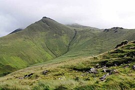
Caherconree is the 2nd-highest mountain of the
Caherconree's
Hill walking
The easiest route is the 4-kilometre 2-hour return trip from the Bóthar na gCloch road (a north-south road between the N86 and the R561 roads); from where an easterly Caherconree Fort Trail goes from the car-park to the ancient promontory fort, from which the summit of Caherconree can be easily accessed.[6][9]
A popular method of climbing Caherconree is via is the Derrymore Glen Horseshoe, a 11-kilometre 5-hour loop that starts from the base of the Derrymore Glen and ascends to the first summit of Gearhane, and then around the "horseshoe" to Caherconree and the summit of Baurtregaum. Options for the descent use either the Baurtregaum NW Top spur or the Baurtregaum NE Top Spur (and the Scragg) to get back to the base of the Glen. The route is recommended for its views of the Glen as well as incorporating most of the main peaks of the Slieve Mish range, and is also called The Slieve Mish Circuit in some guidebooks.[7][6]
Caherconree Promontory Fort
Caherconree is named after an Iron Age stone promontory fort, Caherconree Promontory Fort at 683 metres (2,241 ft), that sits two-thirds of the way up its southwestern shoulder, overlooking the north-south running mountain road called Bóthar na gCloch ("road of the stones").[9][2] The fort is surrounded on three sides by steep cliffs. In Irish mythology this is the fort of Cú Roí mac Dáire, who was able to make it spin around at night to stop attackers finding the entrance.[2]
In the story of Aided Con Roí, a king's daughter called Bláthnat is taken against her will to the fort by Cú Roí. She is rescued by her lover, Cú Chulainn, to whom she signals that the time will be right to attack when she pours milk into a nearby stream; Bláthnat created the opportunity by taunting Cú Roí that his fort was too small for such a magnificent chieftain thus compelling him to take down the walls to build a bigger fort.[2] This stream is now called the Finglas (from an Fhionnghlaise meaning "the white stream") and its source is close to the remains of the ringfort.[2]
Between the summits of Caherconree and Gearhane, is a rock feature called Fin MacCool's Chair, named after the mythical figure Fionn mac Cumhaill.[2]
Gallery
-
 Peak of the hill fort
 -
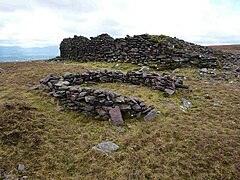 Hill fort ruins
 -
 View south from summit
 -
 Hill fort from summit


See also
- List of mountains in Ireland
- Lists of mountains and hills in the British Isles
- List of Hewitt mountains in England, Wales and Ireland
References
- ^ MountainViews Online Database. Retrieved 8 February 2019.
- ^ a b c d e f g h Paul Tempan (February 2012). "Irish Hill and Mountain Names" (PDF). MountainViews.ie.
- MountainViews Online Database.
- MountainViews Online Database.
- ^ ISBN 978-1-84889-164-7
- ^ ISBN 978-1852841102.
Walk 44 Caherconree, Baurtregaum
- ^ ISBN 978-1848892118.
Route 41: Slieve Mish Circuit
- MountainViews Online Database. September 2018.
- ^ Irish Times. Retrieved 20 July 2019.
External links
- MountainViews: The Irish Mountain Website, Caherconree
- MountainViews: Irish Online Mountain Database
- The Database of British and Irish Hills , the largest database of British Isles mountains ("DoBIH")
- Hill Bagging UK & Ireland, the searchable interface for the DoBIH
| British Isles |  | |
|---|---|---|
| Scotland | ||
| Outside Scotland | ||
| England | ||
| Ireland | ||
| County tops | ||
Mountains and hills of Munster | |||||||||
|---|---|---|---|---|---|---|---|---|---|
| Ballyhoura Mountains |  | ||||||||
| Boggeragh Mountains | |||||||||
| Caha Mountains | |||||||||
| Comeragh Mountains | |||||||||
| Derrynasaggart Mountains |
| ||||||||
| Dingle Peninsula |
| ||||||||
Galty Mountains | |||||||||
Iveragh Peninsula | |||||||||
| Knockmealdown Mountains | |||||||||
| MacGillycuddy's Reeks | |||||||||
Mangerton Mountains | |||||||||
| Shehy Mountains | |||||||||
| Slieve Felim Mountains | |||||||||
| Slieve Miskish Mountains | |||||||||
| Sliabh Luachra | |||||||||
| Others |
| ||||||||
.jpg)
