
Cambria Icefield
The Cambria Icefield is an
icefield in the Boundary Ranges of the Coast Mountains in northwestern British Columbia, Canada, located southeast of Stewart
.
Climate
Based on the Köppen climate classification, the Cambria Icefield is located in a subarctic climate zone of western North America.[1] Most weather fronts originate in the Pacific Ocean, and travel east toward the Coast Mountains where they are forced upward by the range (Orographic lift), causing them to drop their moisture in the form of rain or snowfall. As a result, the icefield experiences high precipitation, especially during the winter months in the form of snowfall. Temperatures can drop below −20 °C with wind chill factors below −30 °C.
Gallery
-
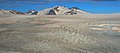
 Cambria Icefield
 -
 Bromley Peak and Cambria Icefield
 -
 Mount Camber and Cambria Icefield
 -
 Mount McLeod and Cambria Icefield
 -
 Mt. Magee (left) and glacier descending from Cambria Icefield to Kate Ryan Creek. Mount Camber centered in the distance.
 -
 Otter Mountain, the highest peak of the Cambria Icefield area


References
- S2CID 9654551.
55°48′00″N 129°40′00″W / 55.80000°N 129.66667°W
This article about a glacier in Canada is a stub. You can help Wikipedia by expanding it. |